Past IEM Features tagged: hrrr
Precip Type Forecast
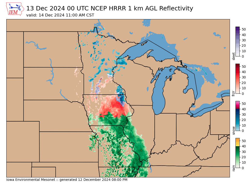
13 Dec 2024 05:30 AMThe most significant winter storm of the season is set to impact the state later today and through Saturday. Of most concern is the accumulation of damaging amounts of freezing rain causing power outages and dangerous travel conditions. Forecasting such events is often tricky as near surface air temperatures may be close to freezing and liquid water freezing near the surface actually releases heat and will warm air temperatures some. One of the main weather forecast models that help meteorologists during these events is the High Resolution Rapid Refresh (HRRR). The HRRR model attempts to forecast not only rainfall, but the type of precipitation hitting the ground. It is also popular for producing a pseudo-RADAR looking output field that resembles reflectivity. Anyway, the IEM attempts to process all of this information and has recently started generating a precip type colored reflectivity plot. The featured plot is a forecast for 11 AM on Saturday. This forecast depicts an area to the south warm enough to support rain (green colors) and then freezing rain with colder temperatures north of about Interstate-80 (oranges) with even colder temperatures to the north supporting snow. Please use care traveling Friday evening and into Sunday morning!
Voting:
Good: 23
Bad: 0
Tags: hrrr
Eclipse in weather models
08 Apr 2024 06:17 AMThe eclipse is finally at hand and hopefully you are able to see it wherever you may or may not have traveled to. While the eclipse at totality only lasts a few minutes, the shadow effects while the moon is partially blocking the sun lasts for an hour or two. The HRRR model includes special code to account for the change in received solar radiation during the eclipse. With instantaneous solar radiation output from the model at 15 minute resolution, the featured lapse nicely shows the impact of the eclipse. You may be wondering about the darkened areas already on the map. That is the effect of clouds reducing the solar radiation received at earth's surface.
Voting:
Good: 10
Bad: 0
Tags: eclipse hrrr
HRRR Postage Stamps
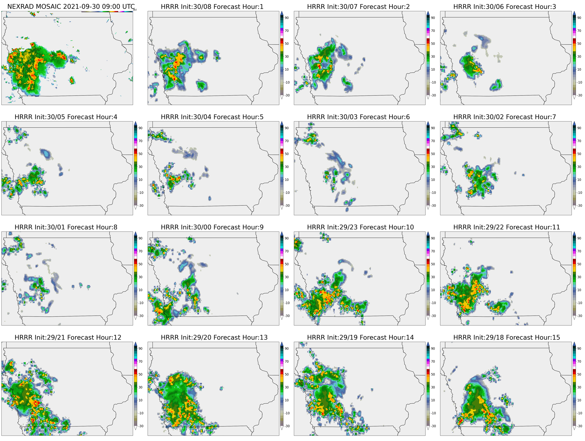
30 Sep 2021 05:36 AMThe High Resolution Rapid Refresh (HRRR) weather forecast model is run by the NWS each hour and produces at least an eighteen hour forecast. Instead of looking at just a single deterministic forecast model run, weather forecasters like to look at ensembles of forecasts to provide probabilities and other statistical measures of forecast likelihood. Since the HRRR model is run every hour with at least hourly output available, one can create a time-lagged ensemble by stitching together the recent runs and looking at each run's forecast at a given valid time. The featured map does this stitching in "postage stamps" format with the top left box showing the actual RADAR mosaic presentation at 4 AM this morning and fifteen other boxes showing the most recent fifteen hourly runs of the HRRR model with that given run's forecast valid at 4 AM shown. While not explicitly forecast, the HRRR model produces a post-processed field that is meant to replicate a RADAR presentation. There's actually significant rainfall in the state this morning and each of the forecast runs shown some amount of storminess at this time. Consistency with the weather forecast over time from a given model provides forecasters with increased confidence that the forecast may be right! You can generate your own HRRR postage stamp plots for a location of your choice and historical date of your choice on this website! The plot takes a number of seconds to generate, so please be patient running the IEM Autoplot 221!
Voting:
Good: 22
Bad: 0
Tags: hrrr
Future RADAR
30 Mar 2016 05:38 AMSome weather prediction computer models are run at a spatial scale that is able to begin to resolve individual thunderstorms. The primary such model in the US is the High Resolution Rapid Refresh (HRRR). The featured map displays a simulated depiction of RADAR reflectivity valid this afternoon at 6 PM. While the HRRR model does not explicitly predict RADAR reflectivity, it does predict many of the hydrometer particles that cause returns on weather RADAR. So with a bit of model output post-processing and assumptions, a simulated depiction of forecasted RADAR reflectivity can be made. The forecast shown for today predicts strong thunderstorms in western Iowa at this time.
Voting:
Good: 16
Bad: 0
Tags: hrrr
Missed Forecast
23 Sep 2015 03:56 AMThe showers and thunderstorms that pushed into western Iowa yesterday and made it to Des Moines was a bit unexpected. One of the main high resolution and short term forecast models run by NCEP/NWS is called HRRR. This model is run every hour producing a 15 hour forecast. The featured map presents the percentage of these runs (15 in total) that had simulated reflectivity above 30 dBz (stronger showers) for 6 PM yesterday evening. The inset map shows the actual RADAR data at that time. Only the last few model runs that afternoon picked up on the showers in west central Iowa and the coverage was under predicted.
Voting:
Good: 25
Bad: 8
Abstain: 5
Tags: hrrr forecast
Model insistence
21 May 2014 05:36 AMThe HRRR model is a recently developed weather prediction system run by NOAA that forecasts weather out for 15 hours and run 24 times per day (each hour). For any given time, there are 15 previous forecasts made for that time. On Tuesday, successive HRRR runs were predicting storm development in western Iowa just northeast of Council Bluffs. The featured map displays the frequency of where the forecasted storm development would be at 4 PM. The higher percentages imply more insistence that the model believed storm development would occur at that location. The inset image shows the actual RADAR presentation at 4 PM and sure enough, the HRRR was mostly correct with the initial development! Please note that a smoother was applied to the data to aid in this comparison.
Voting:
Good: 25
Bad: 11
Abstain: 6
Tags: hrrr


