The Iowa Environmental Mesonet (IEM) collects environmental data from cooperating members with observing networks. The data are stored and made available on this website.
90+ Degree Days
Posted: 04 Oct 2024 05:30 AM, Views: 839
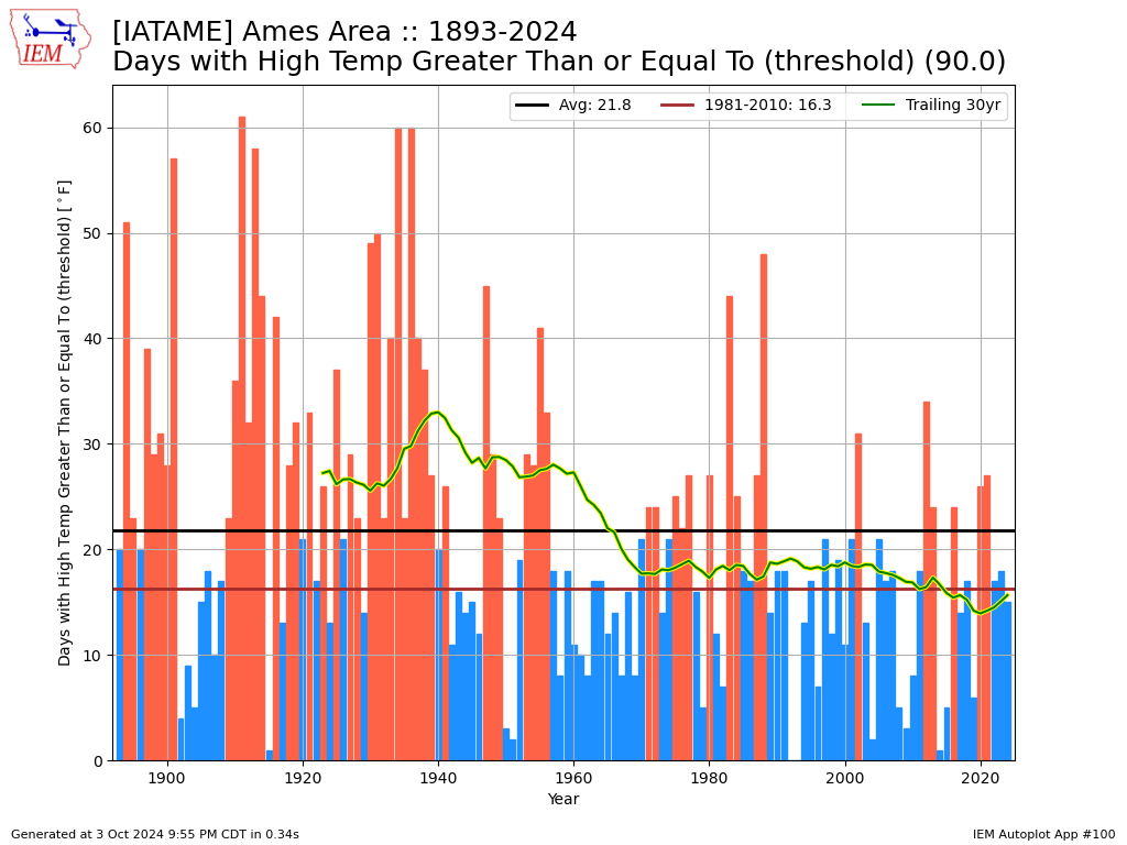
The current forecast has parts of Iowa taking a run at 90° high temperatures this weekend, so it is a good time to check in on the accumulated number of such days each year. The featured chart presents the number of days with a high temperature of at least 90°F for Ames. Each year's bar is colored by either being above or below the simple long term average number of days. The yellow line presents a trailing 30 year average. The long term trend has been downward, but that is largely explained by land use changes modifying the surface energy budget and summer time increases in humidity. It is interesting to see the recent and modest increase in number of days over the past five years or so and if that trend will continue over the coming decade or so.
Rate Feature
Previous Years' Features
2023: High End of Fall Range
2022: Dry September
2021: Partitioning of 70s
2020: October 70+
2017: Ames vs Des Moines
2016: October Severe
2015: 6 months till next 80?
2014: Fall Minimum Percentile
2009: 5 Day Rain
2008: Above freezing so far
2006: Some snow next week?
2004: Our next weathermaker
2003: Big Swing
DeWitt , IA Webcam:
Most Popular (List Apps)
25 Sep Website Issues [resolved]
Posted: 25 Sep 8:04 AM
24 July Potential Partial Outage [resolved]
Posted: 23 Jul 8:53 AM
4 July METAR Data Outage [resolved]
Posted: 4 Jul 8:17 AM
24 Jun NWS Data Outage [resolved]
Posted: 24 Jun 8:56 PM
New KCRG CityCam: Springville
Posted: 11 Jun 7:15 AM
Sign up for the Daily Bulletin
Current Website Performance:
Bandwidth: 16.2 MB/s
Total Website: 2,006 req/s
API/Data Services: 32.6 req/s
API Success: 100%
Soil Temperatures

Data from the Iowa State Soil Moisture Network is found on this website and daily soil temperature averages are used to produce the highlighted analysis.


