Past IEM Features tagged: 2013
Days with past 30 days below 33%
18 Oct 2013 05:40 AMThe drought situation in the state has been much worse for some locations than others. The featured map is an attempt to illustrate this by counting the number of days this growing season (1 May to 1 Oct) that the previous 30 days had less than 33% of average accumulation. The area to the north and west of Des Moines shows up prominently in this analysis and is where the current most significant drought depiction is located for the state. Northeastern and far western Iowa shows up favorably on this map with few days meeting this arbitrary criterion.
Voting:
Good: 154
Bad: 19
Tags: 2013
Continued Complex Drought
14 Oct 2013 05:36 AMThe drought situation in the state remains very complex. The featured chart shows time series of trailing 30, 90 and 365 day trailing departures for statewide areal averaged precipitation. The current drought analysis for the state has a small portion in D3 designation and another small portion in no drought with the rest of it in D0 to D2. The chart shows that the year long departure is now well above average while the 90 day is well below. This is due to the wettest spring season on record helping the 365 day departure while the 90 day no longer includes that period. This year's growing season is now done, so any rain now will go toward helping the soil moisture situation for next year. Some rain is expected later today, but then the forecast turns dry again.
Voting:
Good: 79
Bad: 68
Tags: 2013
Besting recent months in one day
05 Oct 2013 05:42 AMDes Moines received just over two inches of rainfall on Friday, which was almost larger than the individual monthly totals for each of the past three months! The featured chart presents the July, August, and September monthly totals for Des Moines along with the single day maximum precipitation for October during the same year. Both 2012 and 2013 have come close to exceeding a previous monthly total in just one day in October. The only year to accomplish this feat since 1880 was 1947!
Voting:
Good: 151
Bad: 9
Tags: 1947 2012 2013
Less than 20%
16 Sep 2013 05:43 AMThe featured map is an analysis of precipitation accumulation percentage of normal since 1 July. For the period, the driest part of the state has been the around the Rockwell City area with less than 20% of average amount received. All of the state is shown below 70% with the extreme northwestern portions faring the best. The forecast does have chances of rain this week along with a return of 80 degree temperatures.
Voting:
Good: 72
Bad: 11
Tags: 2013
Drought Hole
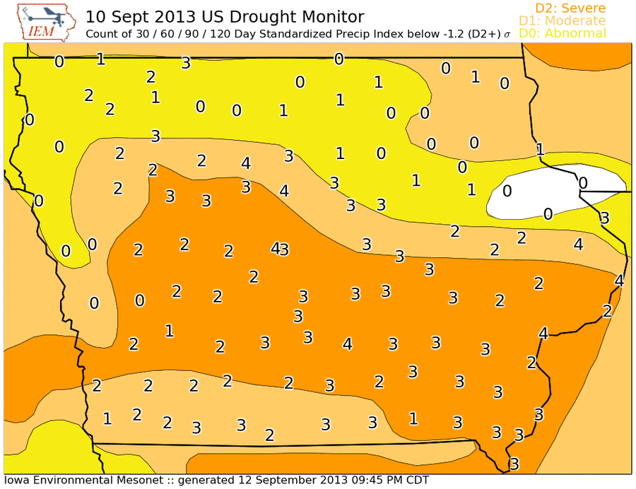
13 Sep 2013 05:44 AMThe United States Drought Monitor is a hand drawn analysis of weekly drought condition in the country based on quantitative and qualitative measures of drought. The featured map shows the most recent analysis valid on the 10th. The entire state except about two counties is shown in some level of drought condition. The plotted numbers are IEM computed counts of the number of recent periods having a precipitation departure of at least negative 1.2 standard deviations from average. Four periods are shown covering the recent 30, 60, 90, and 120 days. So if a location has a four plotted, each of those periods has a precipitation departure worse than negative 1.2 sigma. The negative 1.2 level is about when "D2" drought is to be analyzed. The numbers show the most consistently dry areas of the state are from central to southeastern Iowa. Northeastern and extreme western Iowa have not been as dry.
Voting:
Good: 202
Bad: 29
Tags: 2013 drought
Accumulated Precipitation
06 Sep 2013 05:44 AMWill 2013 be remembered for being a wet year or a dry year or both? The featured chart displays the statewide accumulated precipitation for this year, last year, 1993 (wettest year), and 1988 (driest year). The shading represents the range of values since 1893. Around the end of June, this year was the wettest to date on record, including 1993. The weather since then has been very dry and how the year to date accumulation is approaching merely average with 1993 some 15 inches higher! The forecast continues to hold little hope of widespread precipitation.
Voting:
Good: 146
Bad: 16
Tags: 2013 2012 1993 1988 precip
Complex Drought
05 Sep 2013 05:38 AMThe current drought situation in the state is very complex as shown by the featured chart displaying trailing departures for IEM computed statewide areal averaged precipitation. While the 365 day window is slightly above long term average, the 30 day and 90 day are well below. The wettest spring season on record for the state is what is currently allowing most crops in the state to hold on. The chart shows an interesting combination of the 365 day departures becoming less negative while the 30 and 90 day go the opposite direction. The reason being the wet spring replacing a much drier period during the previous year and that same period falling out of the 30 and 90 day windows. So while the dramatic drop in 90 day departure screams a flash drought, the long term departure is being bolstered by the wet spring.
Voting:
Good: 58
Bad: 7
Tags: 2013
104 on Aug 30th
03 Sep 2013 05:27 AMOur recent stretch of hot weather has thankfully come to an end. Des Moines topped out at 104 degrees on Friday, which was the warmest temperature on record this late in the year. The featured chart displays the latest date of the year for a given high temperature. The 104 for Des Moines set the latest date for the 104, 103, and 102 temperature levels. The year of the temperature record is shown as well. Temperatures are expected back into the 90s next week with next to zero chances of precipitation.
Voting:
Good: 68
Bad: 4
Tags: 2013 highs
4x
30 Aug 2013 05:13 AMThe featured chart displays the ratio of total statewide averaged precipitation in April and May to that in July and August of the same year. The ratio this year is well over four meaning that four times as much precipitation fell this April and May versus this July and August, which is by far the largest ratio shown since 1893. The long term average is close to one meaning these paired two months receive about the same total, but the year to year variability is high. The good news is that the heat looks to break in time for the start of September, but significant rainfall is not expected.
Voting:
Good: 238
Bad: 26
Tags: 2013
Reaching 2600 GDDs
08 Aug 2013 04:41 AMGrowing Degree Days are commonly used to track crop development. For "105 day" corn, about 2600 GDD units are necessary to reach maturity. The cool and wet spring combined with a early May snowfall made it difficult for corn to get into the ground on time in Iowa. Planting corn deep into May and June puts the crop at risk of not accumulating enough GDDs prior to the fall freeze. The featured chart attempts to provide probabilities of accumulating GDDs based on the combination of growing season begin (planting / crop emergence) and end (first freeze) date. The left hand plot shows the overall frequencies based on yearly data for Ames since 1893. The right hand plot combines what has already happened this year with scenarios based on all previous years for 7 August and on. For example, for a corn crop emerging on 15 May, about 20% of the years got to 2600 GDDs by 15 September prior to the first fall freeze. Given this year's condition, for a corn crop emerging on 15 May, there is near no chance that 2600 GDDs can be reached by 15 September and only about 50% of all years will get us to 2600 GDDs at all. One mitigation is that as planting dates get later, farmers will plant hybrids with shorter maturities (less GDD requirements). Although, this seed change is not always logistically possible. The chart would indicate that we need to make it through much of September without a freeze to give the longer maturities a chance.
Voting:
Good: 152
Bad: 11
Tags: gdd 2013
Drought creeps back
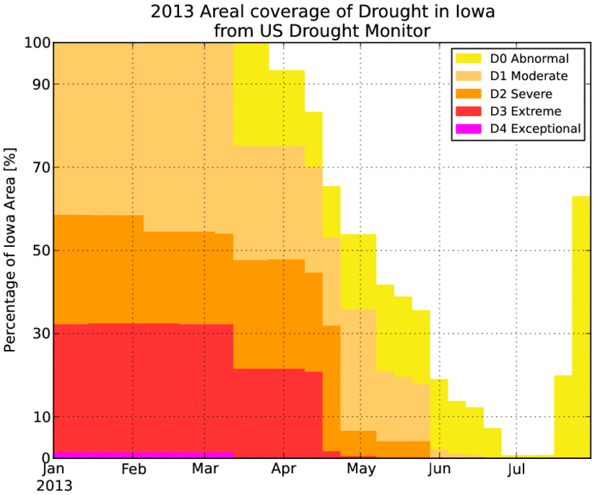
26 Jul 2013 05:36 AMThe precipitation gains made this spring to practically eliminate the drought condition in the state are being lost thanks to a dry June and July. The featured chart shows the percentage of the state covered by analyzed drought condition from the National Drought Monitor. The most recent update to this analysis has over 50% of the state now covered by abnormally dry condition (D0). The good news is that there have been recent rains, but the heaviest totals have mostly missed the western half of the state. More chances of rain are in the forecast, but the heaviest totals will be to our south and east.
Voting:
Good: 63
Bad: 6
Tags: 2013 drought
Late Corn Silking
18 Jul 2013 05:45 AMThe featured map displays the estimated percentage of corn areas per state that are currently tasseled/silking along with the departure from the past 30 years average for the second week of July. The western Corn Belt is way behind with only 1% estimated in both Iowa and Minnesota. The corn crop is behind schedule due to late planting dates because of cold spring weather and wet conditions. These estimates were valid for four days ago and a visual survey of your local corn crops probably shows more acres now tasseling. This is an important time for corn development and it desperately needs moisture. Having hot and dry conditions during this period is not good for the eventual yield.
Voting:
Good: 84
Bad: 12
Tags: corn 2013
Below average precip returns
10 Jul 2013 05:35 AMAfter a very wet spring and a wet June for some in Iowa, July has started off dry. It is hard to believe that we are again worried about precipitation departures, but they are back for much of the state. Extreme northeast Iowa got some very large totals in June and has seen the limited July precip events so far. The forecast for the next week looks very dry and so this situation appears to only get worse. For farmers, we are left with a late planted crop that will be needing rain soon after whatever soil moisture reserves built up from this spring are exhausted. Remember that we came into this spring with very low moisture reserves due to the drought of 2012.
Voting:
Good: 107
Bad: 23
Tags: 2013
Limited dry period
11 Jun 2013 05:41 AMGetting the crops planted this year has been a major struggle after a snow event to start May, cool temperature, and frequent rain events since. The featured map is an analysis of the maximum time period in between hours with at least 0.05 inch of precipitation. Restating, the longest we have gone since 1 May in between rain events. The region with the most difficult time planting this season clearly shows up from northcentral Iowa up through central Wisconsin. Areas around La Crosse are shown in the 5-6 days range. Most of the corn is finally planted, but soybeans are still way behind. The near term forecast has chances of heavy rainfall for these same areas.
Voting:
Good: 61
Bad: 11
Tags: 2013
Already besting last year
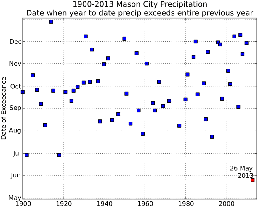
03 Jun 2013 05:29 AMIowa has gone from drought conditions to flooding with the wettest spring on record. Mason City has already received more precipitation this year (21.42 inches) than all of last year (20.42 inches)! The featured chart presents the date of the year when the total precip exceeded the total from the previous year. This condition does not happen every year, so those years have no value plotted. This year beats any other year by 30+ days!
Voting:
Good: 69
Bad: 6
Tags: 2013 masoncity
Wettest Spring
30 May 2013 05:41 AMThe meteorological spring season includes the months of March, April, and May. All of the rain and snow these past three months have contributed to the what appears to be the wettest spring on record for Iowa as shown by the featured graph. The numbers shown are IEM estimates and differ from the official values from the State Climatologist due do differences in the areal averaging technique. Regardless, the preliminary estimates from the State Climatologist have this year as the wettest on record as well. We still have two days of May left and there are more chances of rain and severe weather.
Voting:
Good: 65
Bad: 13
Tags: 2013 spring
100s in May
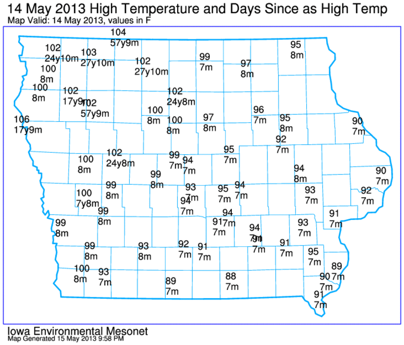
16 May 2013 05:42 AMHigh temperatures on Tuesday exceeded 100 degrees over most of northwestern Iowa. The featured map displays reported high temperatures from the ASOS + AWOS network and the period since as warm a temperature was reported. For some locations, this was the warmest weather in nearly 60 years! This is remarkable considering that it is only the middle of May and we are still two months away from the climatological warmest time of the year.
Voting:
Good: 38
Bad: 8
Tags: 2013
Corn Progress
07 May 2013 05:42 AMThe USDA released their weekly update on corn planting progress and the featured map shows the estimated percentage that has been planted by state along with the departure from average for the first week of May. Our wet and mostly cold April has put the Midwest states well behind average. Typically, about half of the corn acres should have been planted by now. Some of the eight percent estimated to have been planted in Iowa may have to be replanted as cold rain and snow might have damaged the seed. The good news is that the weather appears to have straightened out with warmer temperatures and mostly dry conditions.
Voting:
Good: 55
Bad: 5
Tags: corn 2013
48 degrees
02 May 2013 03:40 AMMay Day felt more like Mother Nature yelling "mayday" as very cold air along with snow entered the state. The cold front still bisected the state by mid afternoon on Wednesday leaving the far eastern portions in the warm air. Temperatures soared well into the 80s while northwest Iowa was near freezing. The featured top chart displays the hourly temperature difference between Burlington and Sioux City since 1 March. The largest difference was 48 degrees with Burlington reporting 82 degrees while Sioux City was at 34. Based on IEM archives, this was the largest temperature difference between the sites on record for May. The largest difference for any month is 61 degrees on 14 Dec 2008.
Voting:
Good: 59
Bad: 9
Tags: 2013 front may
Limited planting progress
30 Apr 2013 05:39 AMThe calendar is about to turn into May, but nearly all of the state's agricultural ground has yet to be planted. The wet and cold April has created two problems for farmers. Fields are too wet to transverse with equipment and the soil is too cold to support growth. The featured chart presents the weekly USDA corn crop planting progress report. Only a few years since 1979 have been as slow as this year. Our recent few days of warm and mostly dry weather has allowed some to get started, but the weather is about to turn very cold and wet for early May.
Voting:
Good: 44
Bad: 7
Tags: 2013 corn
Jump into spring
29 Apr 2013 05:48 AMWarm air finally arrived for much of the Midwest this past weekend. The featured map displays an analysis of the difference between the high temperature on Friday to the warmest temperature reported up until that date this year. Much of Wisconsin, Minnesota, and North Dakota is shown in the 15-30 degree range. This represents a rather remarkable "jump into spring". Unfortunately, much colder air is forecasted to arrive midweek and highs this coming Friday only in the 40s!
Voting:
Good: 39
Bad: 8
Tags: 2013
Wet two days
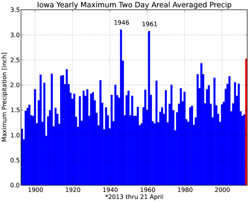
22 Apr 2013 04:39 AMThe featured chart presents an IEM computation of the maximum two calendar day precipitation total for Iowa. The two day total from last week's storm came in at just over 2.5 inches, ranking it third all-time behind 1961 and 1946. While this event has produced flooding, it has also put a huge dent into the drought situation in the state. More rain and even some snow for northwestern Iowa is in the forecast for today.
Voting:
Good: 41
Bad: 4
Tags: 2013 1961 1946
Net days above average
17 Apr 2013 04:40 AMOur weather has been on the cold side of average for much of the past two months. The featured chart shows the accumulated net number of days with a high temperature above average for Ames. The comparison between 2013 and 2012 ends around 17 February as about every day after that was above average in 2012 and most have been below this year. For this metric, 2012 was the most extreme year for net number of days above while 1979 had the most below. 1947 has the closest fit to this year and is shown as well. The cold weather looks to continue into next week.
Voting:
Good: 87
Bad: 9
Tags: 2012 2013 1979
Cold temps for hail
11 Apr 2013 05:45 AMHaving hail from spring time thunderstorms is not an exceptional event. Having hail while near surface air temperatures are near freezing is exceptional. The featured chart compares recently reported hail size and an approximate surface air temperature from a nearby reporting station. It is remarkable to see so many hail reports at temperatures even below freezing. The thunderstorms were feeding off of instability based well above the surface. Having a cold layer of air near the surface also helped hail stones to reach the ground without mostly melting on the way down.
Voting:
Good: 69
Bad: 10
Tags: hail 2013
Non-severe March
01 Apr 2013 05:40 AMThis March finished without a severe thunderstorm nor tornado warning issued by the National Weather Service for Iowa. While March is typically an active month for severe weather in Iowa, there have been other years since 1986 like this March as shown by the featured chart. The bottom panel compares the March total number of warnings with the full year total. There is not much correlation between March and the rest of the year. We have yet to have an April without severe weather warnings since 1986. The first week of April looks to be mostly quiet with temperatures struggling today in the 30s!
Voting:
Good: 20
Bad: 4
Tags: march 2013
Monday and Tuesday without snow
26 Mar 2013 05:42 AMOur most recent snow storm stopped producing snow for most of the state on Sunday making for the one of the few snowless Mondays in the past two months. The featured chart displays the number of hours that the Des Moines Airport sensor reported falling snow for each day since the first of the year. Monday and Tuesday have been quite active and this week should be the first week since late January without snow on both days. Our next storm system looks to be produce mostly rain, but there is still plenty of time for another snow storm.
Voting:
Good: 33
Bad: 7
Tags: 2013
This is Iowa Weather
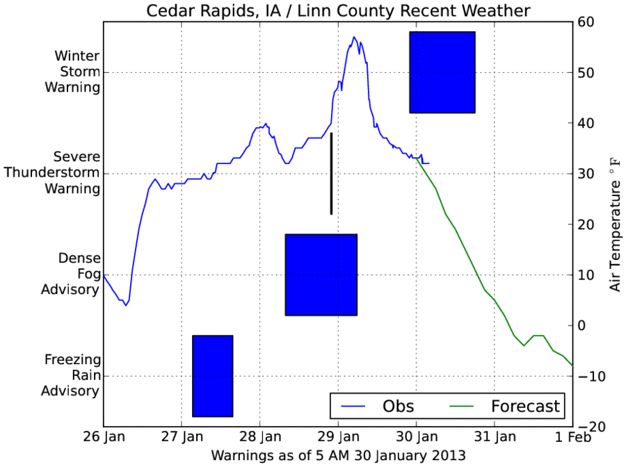
30 Jan 2013 05:12 AMThe featured chart displays a time series of air temperature for Cedar Rapids and NWS issued alerts for Linn County since Saturday. We have gone from cold temperatures, to freezing rain, to dense fog near freezing, to severe thunderstorms, to record high temperatures, to a winter storm and finally brutal cold temperatures. "This is Iowa Weather" many proud Iowans exclaim, but this stretch has been unique and certainly not what typically happens most of the time. Wind Chill Advisories are also in effect for portions of Iowa on Thursday as bitter cold air rushes into the state.
Voting:
Good: 86
Bad: 15
Tags: 2013


