Past IEM Features tagged: may
Rare May Wind + Temp Combo
06 May 2025 05:30 AMMonday was a spectacular early May day of weather for Iowa with afternoon temperatures near 70 and an east to northeast breeze. Such a combination of temperature and wind direction is a bit rare for May as shown by the featured wind rose. The wind rose presents wind speed and direction frequencies during May for Ames when the air temperature is at least 70°F. The smallest frequencies shown are from the ENE and NE. Our present weather is being dominated by a near stationary upper level trough that is "cut off" to our south and east. This has our flow from the east as it spins counter-clockwise. This system will eventually lift northeast and we'll have a chance of showers on Wednesday.
Voting:
Good: 12
Bad: 0
Tags: may
May Winds with 70+ Dew Points
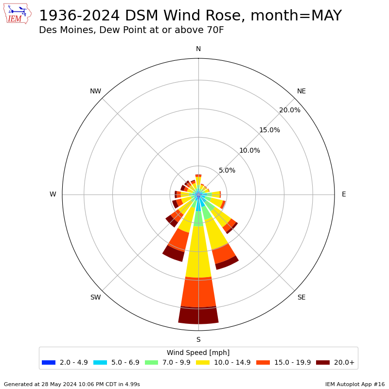
29 May 2024 05:30 AMMuch of May has seen very comfortable temperatures and even with all of the rainfall, humidity levels have not been all that extreme with only the 21st reaching a 70°F dew point for Des Moines. Such high dew points in May almost always require transport of warmer and more humid air masses from our south and sourced from the Gulf of Mexico. Later in the summer season, aggressive crop transpiration and warmer temperatures can help push such dew points without much help from our south. Back to May, the featured wind rose plots the wind speed and direction reports for Des Moines when the coincident dew point is at least 70°F. The southerlies certainly dominate and any of the other directions are likely transient during low speed times and during frontal/storm passages.
Voting:
Good: 15
Bad: 0
Tags: may
May Temp Range
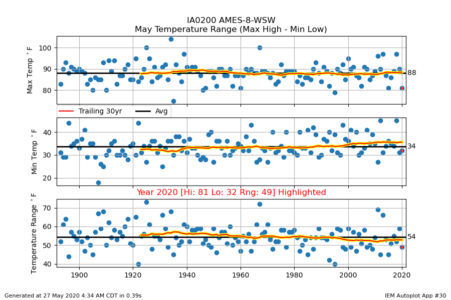
27 May 2020 04:43 AMThe featured chart presents the range between the coldest low and warmest high temperature for Ames during the month of May. Each panel shows the overall average along with a trailing 30 year average. Our average maximum daily high for the month is 88 degrees, so this year's 81 so far is a bit below average. The forecast for the rest of the month does not have optimism that we'll top 81 with highs closer to 70 to finish May.
Voting:
Good: 9
Bad: 0
Tags: may
Historic May Cold
09 May 2020 08:17 AMMorning low temperatures on 9 May 2020 were quite cold for early May with frost reported over much of the state. The featured table presents some preliminary low temperature reports from the main airport weather stations in the state along with some unofficial historical context for how today's low ranks all-time for May and for dates after 9 May. Waterloo and Ottumwa appear to have had their coldest low temperatures this late into the spring season on record. It will be interesting to see how much damage these below freezing temperatures did.
Voting:
Good: 18
Bad: 0
Tags: may
May Dew Points at Temperature
23 May 2016 05:34 AMThe weather this past weekend was rather amazing with warm temperatures and low humidities for much of the state. Only portions of extreme western Iowa got in on the muggy air on Sunday afternoon. The rest of the state was in the upper 70s and lower 80s with dew points well below those levels. The featured chart displays the average dew point at a given temperature in May for Des Moines. The average of 60 degree dew points is shown for temperatures in the lower 80s. So the weather we just experienced was certainly a treat! Things will change this week with numerous rounds of storms expected and muggier conditions.
Voting:
Good: 10
Bad: 2
Tags: may
Coldest May Day
12 May 2015 04:29 AMMonday was a chilly and windy departure from the near summer like weather we have recently been experiencing in May. The high and low temperature were both the coldest so far this month for many sites in the state. The featured chart looks at the frequency of a given May day being the coldest for the month. Having the 11th be the coldest day is not out of the ordinary and the chart would indicate that perhaps our coldest weather of the month is now behind us!
Voting:
Good: 11
Bad: 11
Abstain: 7
Tags: may
AM Rain
28 May 2013 05:38 AMA majority of Iowa's summer time rainfall comes during the overnight hours. During the drought of 2012, this contribution was largely missing. So far, 2013 has been a different story with multiple heavy rainfall events happening during the overnight hours. The featured chart presents the hourly precipitation totals for Des Moines and the long term climatology for May. The 3-8 AM totals have far exceeded climatology. The totals shown were up until 12 AM this morning and another half inch was fallen today.
Voting:
Good: 91
Bad: 7
Tags: may
48 degrees
02 May 2013 03:40 AMMay Day felt more like Mother Nature yelling "mayday" as very cold air along with snow entered the state. The cold front still bisected the state by mid afternoon on Wednesday leaving the far eastern portions in the warm air. Temperatures soared well into the 80s while northwest Iowa was near freezing. The featured top chart displays the hourly temperature difference between Burlington and Sioux City since 1 March. The largest difference was 48 degrees with Burlington reporting 82 degrees while Sioux City was at 34. Based on IEM archives, this was the largest temperature difference between the sites on record for May. The largest difference for any month is 61 degrees on 14 Dec 2008.
Voting:
Good: 59
Bad: 9
Tags: 2013 front may
Northwestern Iowa wettest this May
31 May 2012 05:36 AMThe last day of May is at hand and while more rain is failing today, the current difference between May rainfall totals for a location in far NW Iowa is compared against far SE Iowa in today's featured chart. Based on preliminary data, Rock Rapids has seen just over four inches more precipitation than Keokuk so far this May. This would be the largest difference since the early 1970s. Typically, the largest rainfall totals are over SE Iowa in May with the smallest over NW Iowa. So this May has seen a reversal of that, but it is not uncommon.
Voting:
Good: 30
Bad: 7
Tags: may
Coolest day in May
30 May 2012 05:44 AMMay is going to end on a cool note with high temperatures in the 60s for most Iowans and low temperatures into the 40s! This may be the coolest high and low temperatures for the month. The featured chart presents the frequency of a day in May having the coolest high or low temperature. The earlier part of the month is certainly more frequent than the latter part and it has happened previously that the end of the month was the coolest.
Voting:
Good: 34
Bad: 6
Tags: may
Importance of May
29 May 2012 05:37 AMWith May now winding to a close, it appears this month will come in well below average for most of the state. May is an important month to the yearly contribution of precipitation as shown by the featured chart. The chart shows the frequency of having a month with the same direction of departure as the year long total. For example, having this May be below average precipitation along with having the year of 2012 be below average precipitation. Interestingly, May has the largest frequencies in both directions. Precipitation in May can help "set the table" for the rest of the summer, as a wet May leads to wetter soils and more precipitation chances for the summer. A dry May can have the opposite effect. Most concerning is that this chart would indicate a 75% chance of having below average precipitation for 2012.
Voting:
Good: 33
Bad: 7
Tags: may climate precip
May Precipitable Water
24 May 2012 05:55 AMOne of the reasons for our recent lack of rainfall has been the dearth of precipitable water. Precipitable water is a measure of depth of water in a column of air if all phases found were converted to liquid. The featured chart presents the combination of preciptable water analyzed by a weather forecast model and the total rainfall for that day. The upper chart presents the frequency of having rainfall on a given May day partitioned by preciptable water value. Increasing water content in the atmosphere increases our chances of rain. The lower chart presents the combination of daily precip observations against the precipitable water value. The one to one line shows that often the preciptable water value provides an upper bound to the amount of rainfall we may receive. Advection processes help to replenish atmospheric water content so we can get rainfall totals greater than the amount of water in the column of air ("in this house we obey the conservation of mass law").
Voting:
Good: 30
Bad: 6
Tags: precipitablewater may
Severe Weather in May
17 May 2012 05:56 AMMay is an active month for severe weather in Iowa. The featured chart presents the number of county based warnings issued in Iowa by day of May for each year since 1986. The beginning of May this year certainly started off active with severe weather each day, but has recently been very quiet. Humidity values have been on the dry side recently, which among other factors have prevented storms from developing over the past week. Thunderstorms are an important part of our climate as they bring a majority of the yearly rainfall to the state, so we have to take the good (needed rainfall) with the bad (severe weather).
Voting:
Good: 34
Bad: 5
Tags: may
Quite hot for May
26 May 2010 05:09 AMThis past Sunday and Monday saw high temperatures over 90 for most of the state and lows around 70. For May, these two days were some of the warmest on record and the warmest for days prior to 25 May as shown by the featured illustration. The two days were also exceptional for having low temperatures above 70, which was only the sixth time that has happened in May dating back to 1893. All of these values are statewide areal averages computed by the IEM.
Voting:
Good: 19
Bad: 6
Tags: may10 may
7 days below 60!
14 May 2010 06:07 AMThe abnormally cool stretch of weather ended up lasting a full week for Ames with high temperatures not reaching 60 degrees. According to IEM data, this sets a record for consecutive days below 60 in May. The featured chart displays the monthly records for Ames and the most recent year the record was set or tied. During the winter months, a large number of years had the entire month below 60. It is interesting to see that July never has had a high temperature below 60 for Ames since 1893. Temperatures will approach 70 today!
Voting:
Good: 48
Bad: 8
Tags: may10 highs may
The week after a high of 80
07 May 2010 05:34 AMIt was just on Tuesday that high temperatures soared into the 80s here in Ames. The featured chart looks at the observed frequencies of high temperatures above 80 and below 60 after a day with a high above 80. The climatological occurrence of having a sub 60 and above 80 day in May is shown as well (flat lines). With forecasted highs on Friday and Saturday in the 50s (day 3 and day 4), the chart would indicate this is rather rare. Our average highs are in the upper 60s, so we will be well below normal with some locations struggling to even reach 50 on Saturday.
Voting:
Good: 67
Bad: 14
Tags: may


