Past IEM Features tagged: winter2223
The IEM generates per winter storm analyses of snowfall reports over Iowa and tags them by the winter season. Here are the tags used for the previous winter seasons that these maps are available for:
- Winter 2010-2011
- Winter 2011-2012
- Winter 2012-2013
- Winter 2013-2014
- Winter 2014-2015
- Winter 2015-2016
- Winter 2016-2017
- Winter 2017-2018
- Winter 2018-2019
- Winter 2019-2020
- Winter 2020-2021
- Winter 2021-2022
- Winter 2022-2023
- Winter 2023-2024
- Winter 2024-2025
- Winter 2025-2026
'22-'23 Winter Storm #27
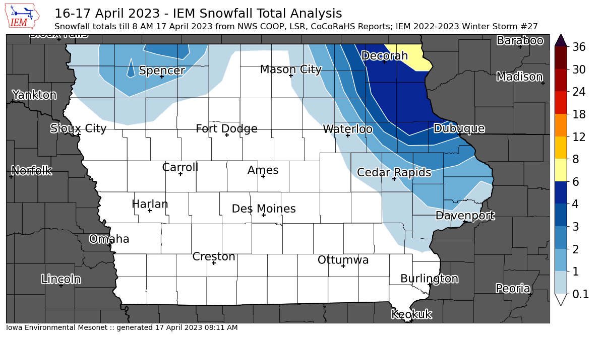
17 Apr 2023 08:16 AMYikes! The week of high temperatures in the 80s has been replaced by accumulating snow over northern and northeastern Iowa. The featured map is an attempted analysis of available NWS and CoCoRaHS reports. These snowfalls are difficult to measure as much of the snow melted during the day on Sunday. Additionally, the lowest contour interval for this map is 0.1 inches, so all of the locations that reported a Trace of snowfall are not shown by this map. Anyway, far northeastern Iowa got a lot of snow and even higher amounts can be found off to the north and east in Wisconsin. Snow this time of year has very little chance to stick around and the warm soil temperatures from last week will further help to get rid of it. Unfortunately, there is some more cold in the forecast for the upcoming weekend.
Voting:
Good: 12
Bad: 2
Tags: winter2223
'22-'23 Winter Storm #26
02 Apr 2023 10:28 AMAs a cruel April Fool's joke, the overnight on Friday into Saturday brought some snow to far northern Iowa and was even enough to prompt a Blizzard Warning over portions of far northern Iowa. This was after very warm temperatures on Friday along with strong tornadoes over southeastern Iowa! Snow totals were rather meager and sunshine on Saturday made quick work to remove most of it. Unfortunately, Tuesday into Wednesday of this week looks to repeat what happened with our most recent storm event.
Voting:
Good: 115
Bad: 1
Abstain: 1
Tags: winter2223
'22-'23 Winter Storm #25
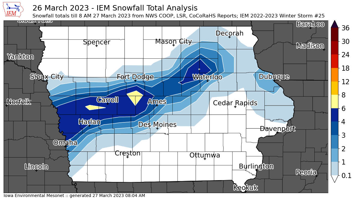
27 Mar 2023 08:07 AMSunday brought a very intense and narrow band of heavy snowfall to portions of northern and western Iowa. The featured analysis of available NWS and CoCoRaHS reports is struggling a bit to accurately portray the sharp gradient on both the north and south side of this stripe of snow. This snow also was very rich in water and fell during the daylight, so melting and compaction made snowfall measurements very tricky. The good news is that this snow will not stick around long as sunshine today will make quick work of it.
Voting:
Good: 11
Bad: 3
Abstain: 1
Tags: winter2223
'22-'23 Winter Storm #24
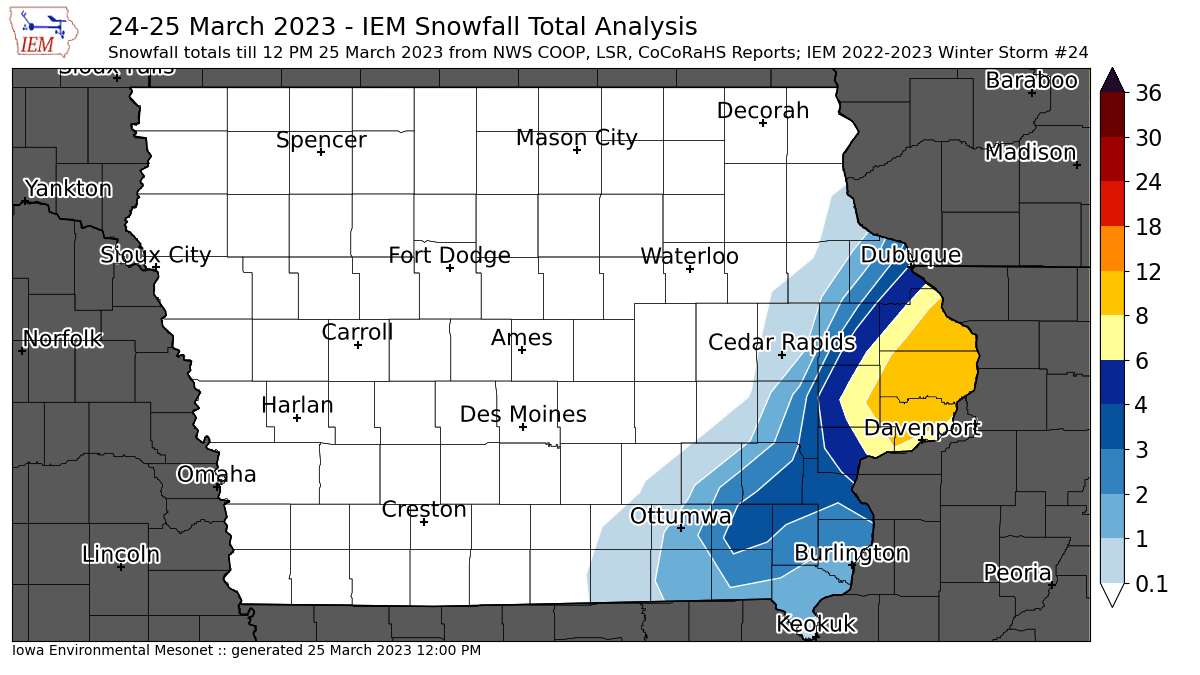
25 Mar 2023 12:06 PMFar eastern Iowa got clipped by a lot of snow this Saturday morning with a number of reports over 10 inches found just north of Davenport. The western cut off to the snow was very sharp and likely a bit under-done with this analysis. More snow is likely on the way for this evening and into Sunday.
Voting:
Good: 10
Bad: 0
Tags: winter2223
'22-'23 Winter Storm #23
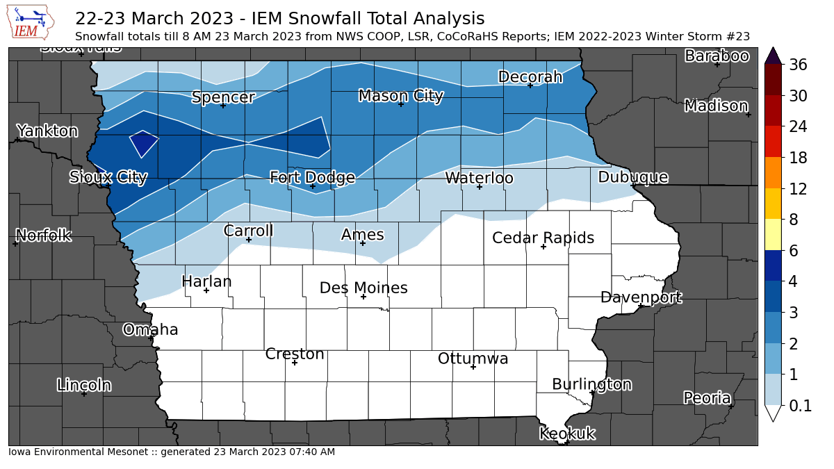
23 Mar 2023 07:43 AMAn overnight storm brought upwards of four inches over northern Iowa. The featured map presents a current analysis of available NWS and CoCoRaHS reports. Temperatures are safely below freezing over this area, so roads are in rough shape this morning. Another round of snow is expected Friday night, so winter continues to hold on even after the calendar flipped to astronomical spring earlier this week.
Voting:
Good: 12
Bad: 0
Tags: winter2223
'22-'23 Winter Storm #22
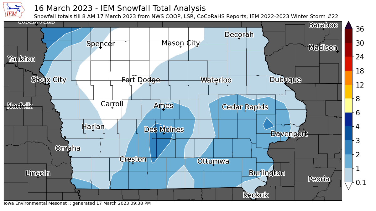
17 Mar 2023 08:10 AMThe most recent storm failed to produce much in the way of snow over Iowa, but much colder temperatures and strong winds are certainly being felt this Friday morning. The featured map presents an analysis of available snowfall reports with the largest amounts of just over a few inches confined to far northwestern Iowa. Thankfully warmer weather is in the forecast for next week, but for those of you that had "spring break" this week, there was not much spring weather to be found unless you went south!
Voting:
Good: 9
Bad: 2
Tags: winter2223
'22-'23 Winter Storm #21
12 Mar 2023 07:57 AMA somewhat surprising Saturday snowstorm surpassed forecast expectations and dumped a significant amount of very wet snow over central Iowa. The heaviest totals approaching eight inches were found over the western Des Moines metro area. As with the storm this past Thursday, the majority of the snow fell during the daytime and compacted/melted making for a difficult measurement. Temperatures were slightly cooler than Thursday, so less rain mixed in with the snow and thus boosted totals. It looks like this snow will stick around for a few days as a return to warmer weather arrives later this week.
Voting:
Good: 124
Bad: 1
Tags: winter2223
'22-'23 Winter Storm #20
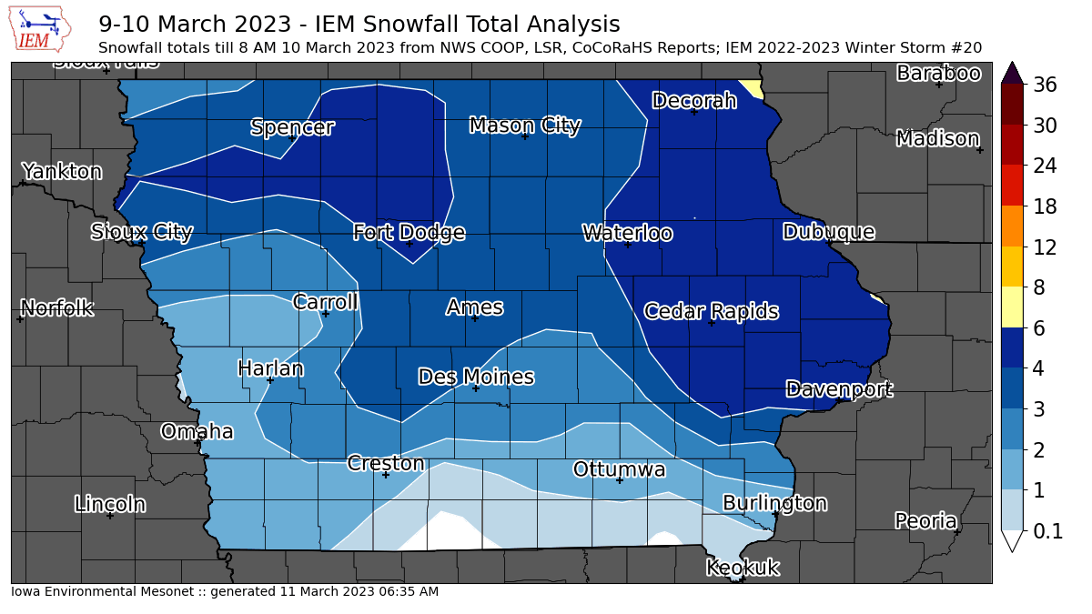
10 Mar 2023 07:11 AMMeasuring snowfall is often not easy! Sometimes the snow is fluffy and wind blows it into uneven piles. Sometimes the snow falls as a slushy mess with melting and compaction both working to reduce its depth. Early spring season snowfalls during daylight hours can receive significant melting even with cloudy conditions as solar insolation will heat the surface. So measuring the snowfall from Thursday is fraught with peril and the featured map will need updated later today as more reports are received and a better analysis can be made. The highest totals were found over far eastern Iowa with a few reports of six inches made.
Voting:
Good: 9
Bad: 1
Tags: winter2223
'22-'23 Winter Storm #19 - Icing Reports
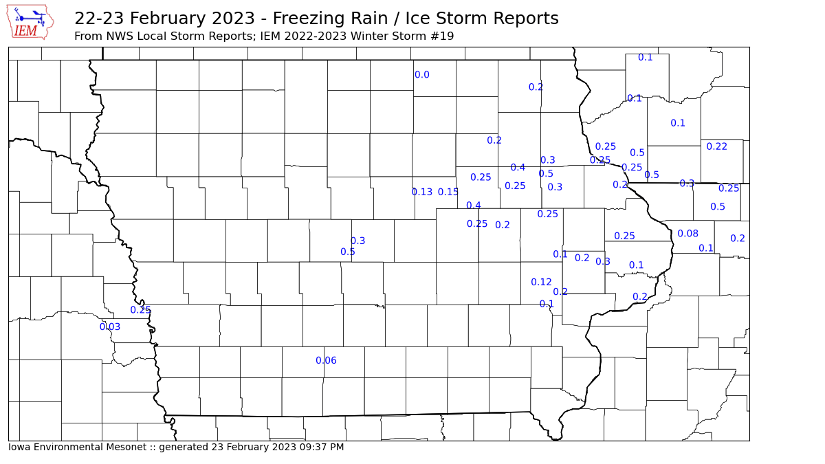
24 Feb 2023 05:30 AMBesides bringing heavy snowfall to far northern Iowa, a good chunk of Iowa roughly between highways 20 and 30 received significant amounts of ice. The featured map presents available NWS Local Storm Reports of ice accumulation. If you think measuring snowfall is difficult, measuring ice accumulation is next level! That issue aside, reports in the tenth to half an inch range can be found from around Ames to Dubuque and then to points east to Michigan. Unfortunately a round of light snow arrives on Friday, which will delay the melting of this ice until Saturday when warmer air works its way back into the state.
Voting:
Good: 15
Bad: 0
Tags: winter2223
'22-'23 Winter Storm #19
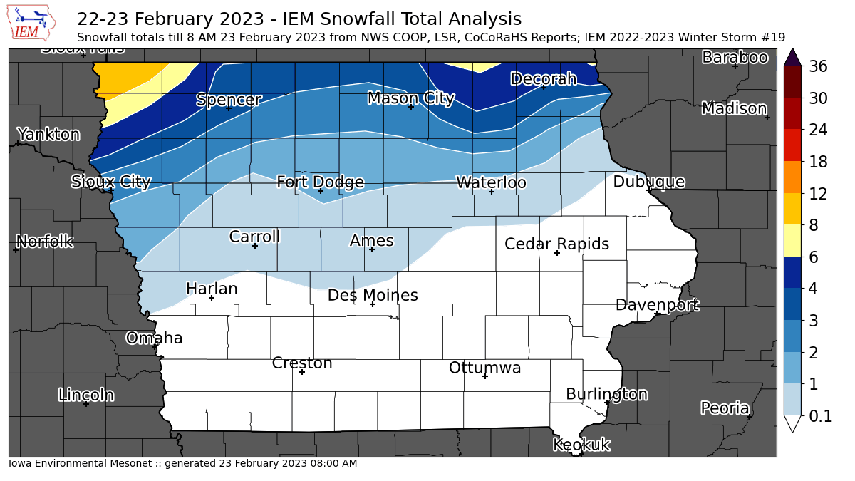
23 Feb 2023 08:04 AMThe last of the big winter storm is about to exit the state this Thursday morning and a large mess is left behind over northern Iowa. The featured map presents an analysis of available snowfall reports with the highest totals to be found over far northwestern Iowa. Much of northern Iowa picked up significant amounts of freezing rain and sleet. Travel remains very difficult as plummeting temperatures today are not helping with the snow and ice removal from roads. Will likely have a featured map tomorrow of available freezing rain and sleet reports.
Voting:
Good: 12
Bad: 0
Tags: winter2223
'22-'23 Winter Storm #18
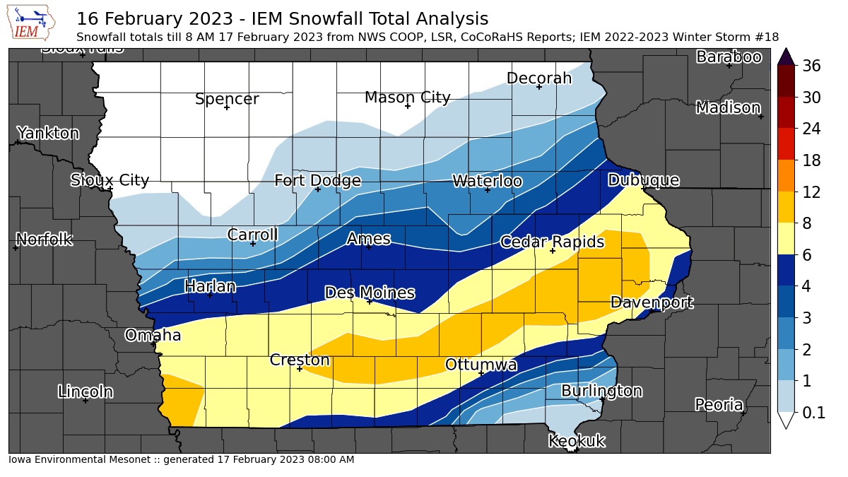
17 Feb 2023 08:05 AMAfter the first big storm this week brought mostly rain, the second big storm brought mostly snow and quite a bit of it over portions of southern Iowa. The featured map presents an analysis of available NWS and CoCoRaHS reports. The highest totals around 10 inches were found near Iowa City and points off to the southwest. The snow was really dumping at times during the day and made for horrible driving conditions. Additionally, a rapid drop in temperatures after the snow stopped turned things to ice late Thursday afternoon. After a very chilly start this Friday morning, sunshine today and warmer temperatures this weekend will help melt this snowfall away.
Voting:
Good: 23
Bad: 2
Tags: winter2223
'22-'23 Winter Storm #17
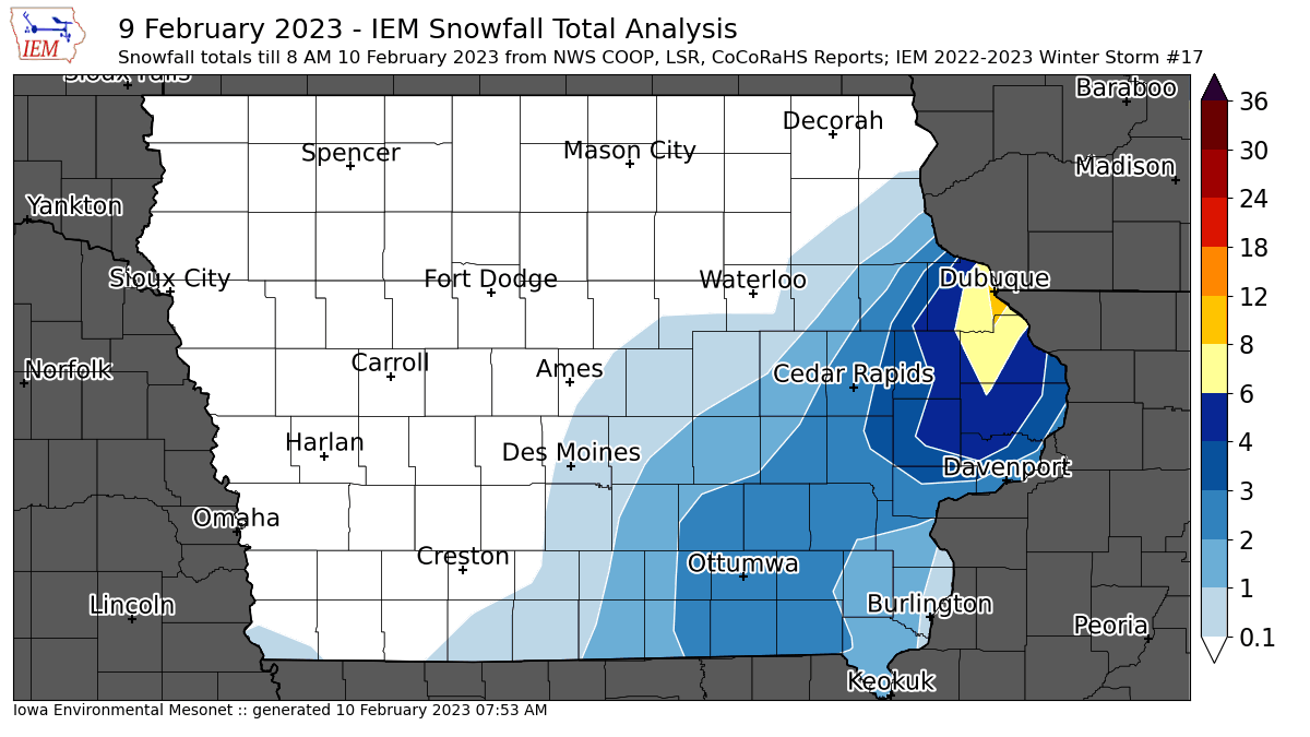
10 Feb 2023 07:56 AMThe featured map presents a smoothed analysis of available NWS and CoCoRaHS snowfall reports for the event on Thursday over Iowa. Events like this one are tough to observe as snowfall totals were highly variable and melting was occurring as the snow was also falling. The clear "winner" for this event was the Dubuque area which had a number of nine inch reports and that snow fell quickly Thursday morning. The good news is that the forecast continues to look mild, so continued melting for this snow and the remaining snow pack over northern Iowa will occur.
Voting:
Good: 12
Bad: 1
Abstain: 1
Tags: winter2223
'22-'23 Winter Storm #16
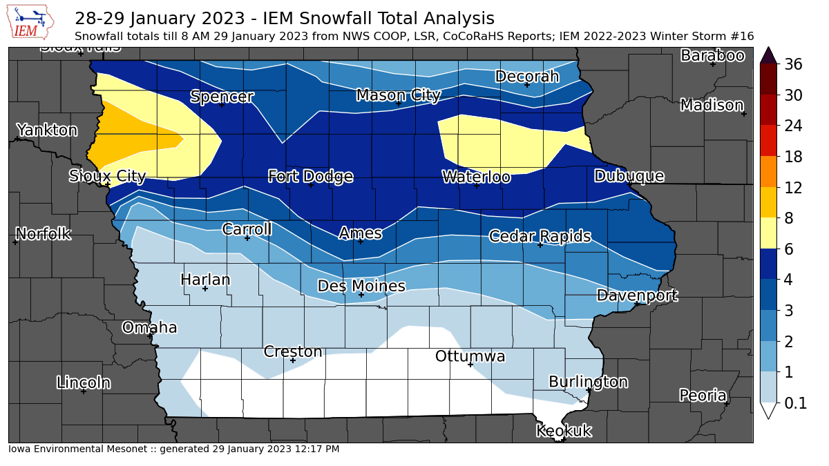
29 Jan 2023 12:22 PMA prolonged snow event lasting from early Saturday morning into Sunday morning brought a stripe of heavy snowfall over northern Iowa. The largest totals were found north of Sioux City near ten inches. Amounts trailed off to the south with a chunk of southern Iowa receiving no snowfall. Everyone is getting in on the cold weather that followed this snowfall with temperatures back to the bitter levels we had avoided since the outbreak before Christmas. The forecast this week looks to be quiet with an early week significant storm slipping off to our south.
Voting:
Good: 19
Bad: 12
Tags: winter2223
'22-'23 Winter Storm #15
25 Jan 2023 12:54 PMIowa got clipped by a large winter storm system off to our south and east on Tuesday and into Wednesday. The heaviest snowfall totals were approaching four inches over far southeastern Iowa. Light snow continues to fall of some locations, so this map will be refreshed tomorrow once additional reports are received. More chances of snow are in the forecast before a well advertised shot of cold air rivaling what we received just before Christmas arrives for the weekend.
Voting:
Good: 12
Bad: 1
Tags: winter2223
'22-'23 Winter Storm #14
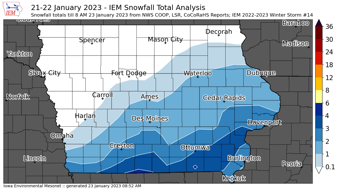
22 Jan 2023 10:53 AMSouthern Iowa had been mostly below average for season to date snowfall, but the most recent winter storm made up some of the difference with the highest totals near four inches to be found along the Missouri border. The featured map presents available snowfall reports from the NWS and CoCoRaHS. Unlike the storm previous which brought liquid rich snowfall, this event was a bit fluffier with snow to liquid ratios closer to the classic 10 to 1 value and even higher. Winter looks to remain firmly entrenched this week with a few chances of snow and temperatures sticking below or near freezing.
Voting:
Good: 13
Bad: 3
Tags: winter2223
'22-'23 Winter Storm #13
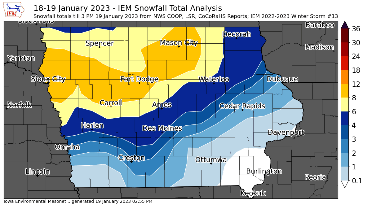
19 Jan 2023 10:09 PMSome snow continues to fall this Thursday morning, so the featured map of available snowfall reports will be updated later today and tomorrow as more reports are received. This snowfall was extremely wet and with snow to liquid ratios well below ten. The heaviest totals are to be found over western Iowa with a few reports of around ten inches. This snowfall created significant travel impacts on Wednesday night as its heavy nature and rapid falling meant snow plows were unable to keep up. Having temperatures near freezing today will help the removal process and hopefully allow applied materials to do work. The issue comes tonight as temperatures will cool and the very wet snow will likely cause refreeze / ice to cause troubles.
Voting:
Good: 16
Bad: 2
Tags: winter2223
'22-'23 Winter Storm #12
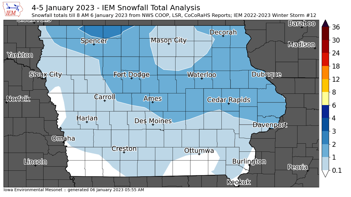
06 Jan 2023 06:02 AMWhile more a continuation of the previous storm, another wave of energy and moisture was able to produce a few inches of snowfall over Iowa on Wednesday into Thursday. A few reports around two inches were made near Spencer and approaching two inches near Cedar Rapids. There's a lot of variability within this smoothed data presentation as the snow showers were isolated and somewhat transient. The near term forecast has mostly dry weather, so hopefully we can take a break from the snow for a little while.
Voting:
Good: 13
Bad: 2
Tags: winter2223
'22-'23 Winter Storm #11
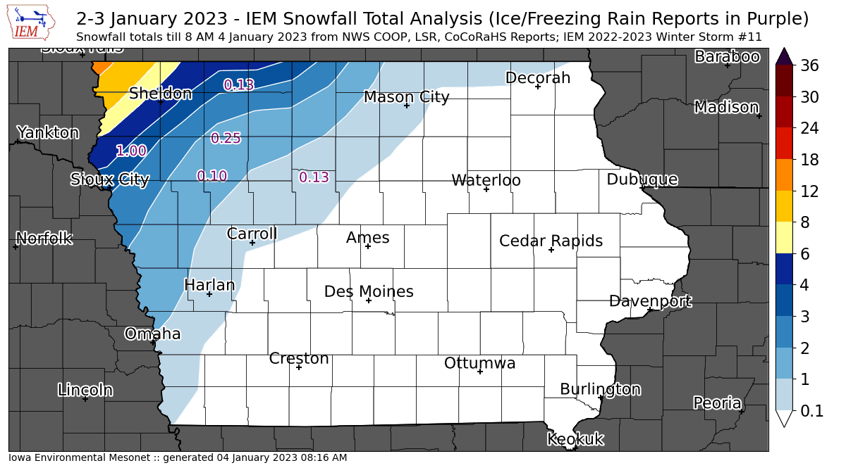
04 Jan 2023 08:21 AMWhile the heaviest snowfall totals with the current winter storm only clipped far northwestern Iowa, much of the rest of the state picked up much needed rainfall. The featured map presents an analysis of available NWS and CoCoRaHS snowfall reports. The plotted numbers represent ice accumulation depth reports. While northwestern Iowa received the worst of this storm, many other parts of the state received enough freezing rain and sleet to make for poor travel conditions on Tuesday that have persisted into Wednesday. A minor dusting of snow and some freezing drizzle will cause more grief today over Iowa.
Voting:
Good: 10
Bad: 0
Tags: winter2223
'22-'23 Winter Storm #10
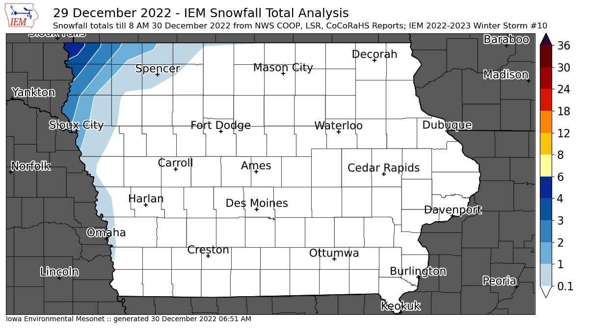
30 Dec 2022 06:55 AMWhile most of the state enjoyed a spring break on Thursday with record high temperatures, extreme northwestern Iowa had snow! The featured map of available NWS and CoCoRaHS reports shows the highest totals in the 2-4 inch range with amounts quickly dropping off to the south and east. Temperatures for all of Iowa will be cooler today and into the weekend. Happy New Year!
Voting:
Good: 21
Bad: 0
Tags: winter2223
'22-'23 Winter Storm #9
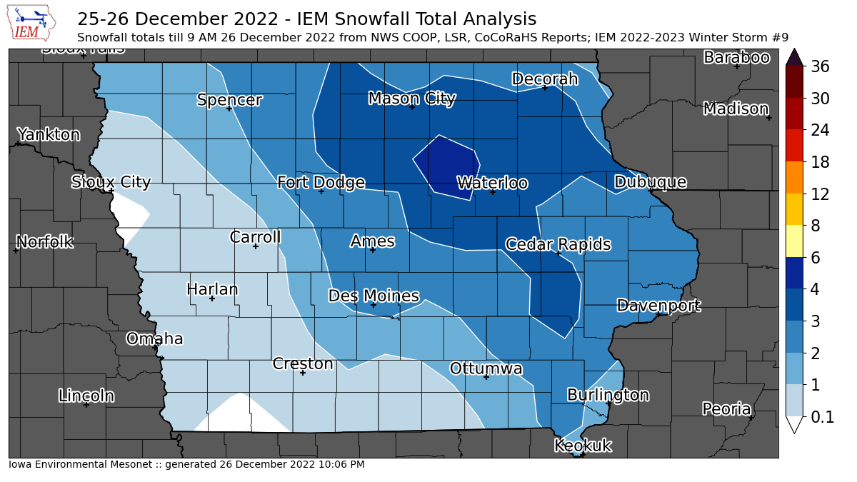
26 Dec 2022 09:12 AMJust as we got cleaned up from the blizzard last week, a quick hitting system brought a few inches of fluff to the state overnight. The featured map shows an analysis of available reports with a patch of three inches confined to northeastern Iowa. Another cold front will sweep the state today and bring along a slight increase in winds. Hopefully not enough to significantly blow around this new fluff, but it is something to be aware of for those of you travelling today.
Voting:
Good: 12
Bad: 0
Tags: winter2223
'22-'23 Winter Storm #8
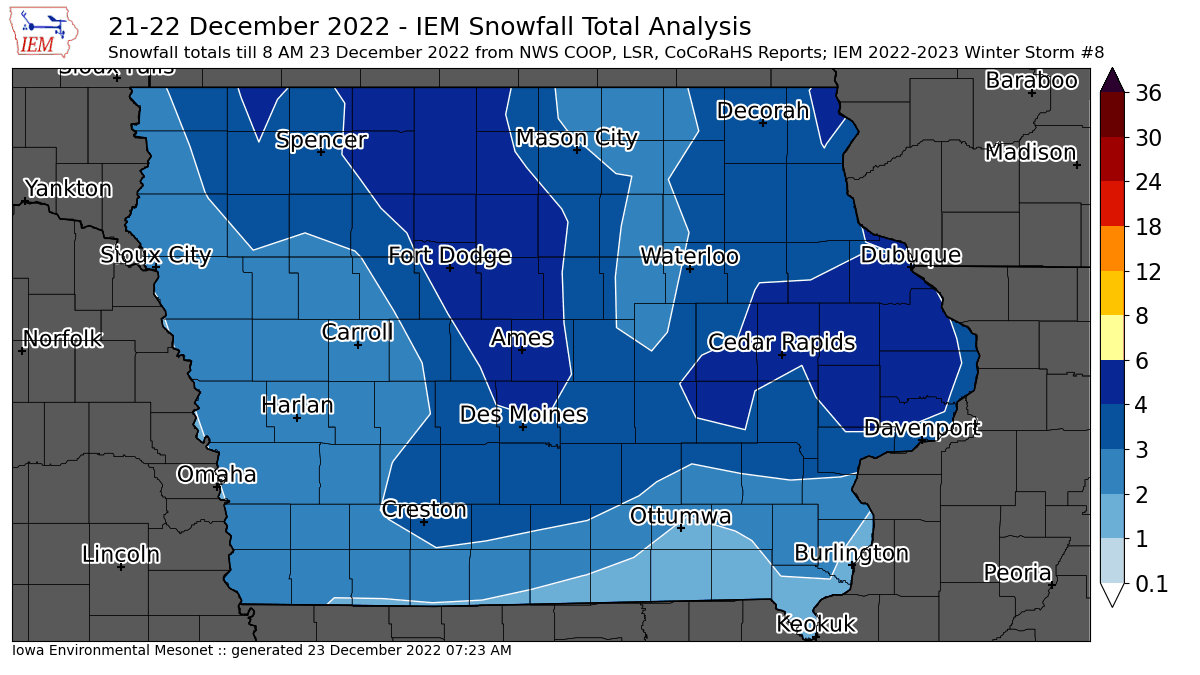
22 Dec 2022 10:07 AMThe snow is about done falling vertically, but is just getting started blowing horizontally. The featured map presents an analysis of available NWS and CoCoRaHS snowfall reports. The map will be updated later today and tomorrow once more data comes in and the ongoing snowfall over SE Iowa finishes up. Snowfall totals did not get out of hand with this storm, but the snow that did fall will easily blow around thanks to its fluffy composition and very strong winds. Extremely cold temperatures and wind chills are present as well, so travel is sub-optimal at the moment. A Blizzard Warning remains in effect for most of the northern half of the state and conditions are not expected to improve much until Saturday at the earliest.
Voting:
Good: 18
Bad: 2
Tags: winter2223
'22-'23 Winter Storm #7
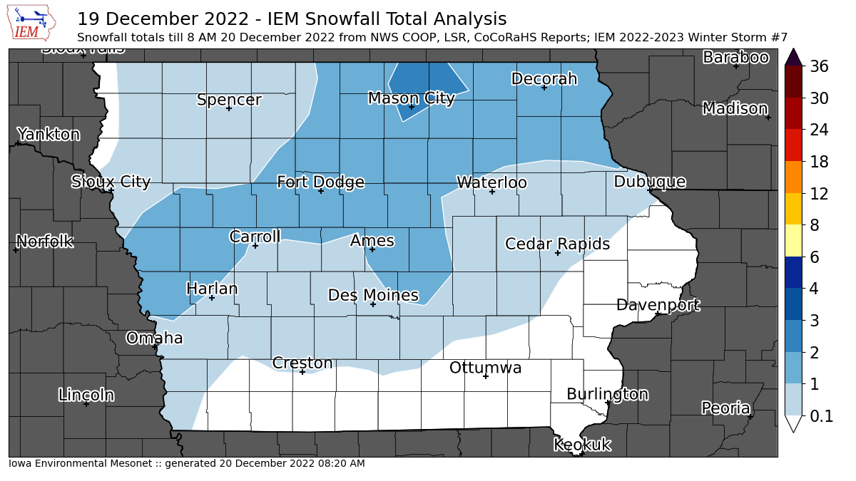
20 Dec 2022 08:25 AMWhile more of an annoying snowfall than anything, a light round of snow visited the state on Monday and into Tuesday. A few isolated two inch snowfall reports were found over far northcentral Iowa. The featured map presents an analysis of available NWS and CoCoRaHS reports. This snow was a bit of a messaging headache as the big storm arrives on Thursday and a massive winter storm watch is already in effect for it. Sadly, sometimes folks conflate the two events and think the forecast already busted due to the minimal snow that fell already. Anyway, the big and impactful storm is still on track. Please pay close attention to the forecast and realize that snowfall totals aren't necessarily important when winds are howling and wind chill temperatures are at life threatening levels!
Voting:
Good: 12
Bad: 2
Tags: winter2223
'22-'23 Winter Storm #6
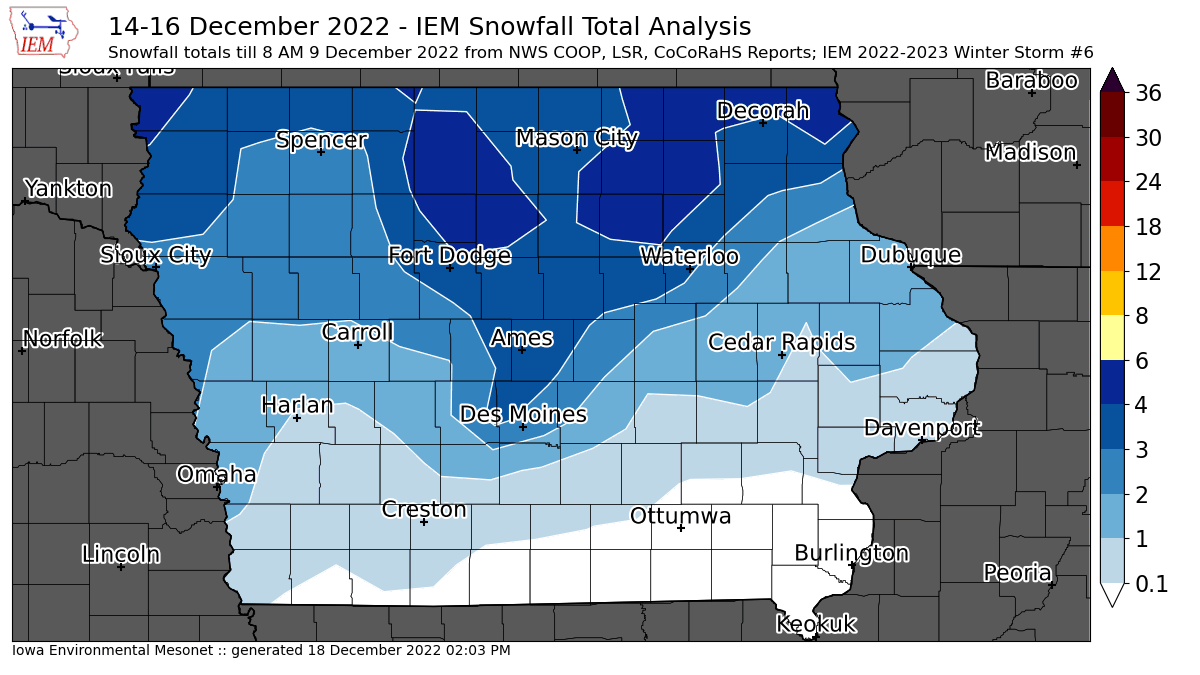
16 Dec 2022 08:20 AMA long duration snow event continues this Friday morning with the featured map attempting to total up available reports over the past two days. Totals were much higher to Iowa's north, but a persistent wind is blowing this snow around and making for tough travel conditions. This map will likely be updated later today or tomorrow as additional snow totals come in. Will this snow stick around until Christmas? The near term forecast does hold out hope for this with very cold weather expected to arrive later next week.
Voting:
Good: 21
Bad: 1
Tags: winter2223
'22-'23 Winter Storm #5
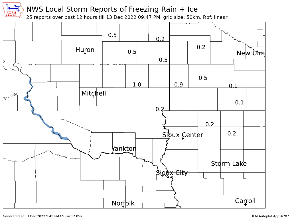
14 Dec 2022 05:30 AMJust to again emphasize, the IEM winter storm accounting are somewhat arbitrary and unofficial. The first wave of a large and powerful winter storm system brought freezing rain to northwestern Iowa and points north. The featured map presents NWS reports of ice accumulation in inches. Fortunately, temperatures warmed for Iowa during the day on Tuesday and mitigated more significant travel impacts. The same storm complex is expected to bring a chance of snow into Iowa on Thursday and into Friday.
Voting:
Good: 11
Bad: 2
Tags: winter2223
'22-'23 Winter Storm #4
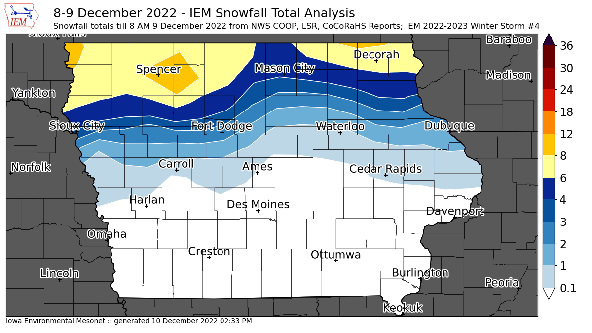
09 Dec 2022 07:59 AMThe overnight winter storm is pulling out of Iowa this Friday morning with much needed moisture falling in the form of snow over far northern Iowa and rain in other places. The featured map presents a current analysis of available NWS COOP, LSR, and CoCoRaHS reports. One note is that far northeastern Iowa may be under-reporting here due to the snow still ongoing and reports made while heavy snow was in progress. So this map may get updated Saturday morning to include those reports. There was lightning and thundersnow observed with this event, which an old forecasting rule of thumb states that somewhere gets at least a foot of snow when that happens, so some isolated higher reports than the 6-8 inch band shows may have occurred.
Voting:
Good: 17
Bad: 1
Tags: winter2223
'22-'23 Winter Storm #3
30 Nov 2022 09:00 AMOur streak of pleasant late fall / early winter weather ended abruptly on Tuesday with a snow storm producing up to six inches over far northwestern Iowa. The featured map presents an analysis of available NWS and CoCoRaHS reports. Temperatures are much colder on Wednesday and a brisk westerly wind has wind chills in the unpleasant category. The near term forecast has a wild roller coaster of temperatures with highs back in the 50s for Friday and then nose diving below freezing on Saturday.
Voting:
Good: 7
Bad: 0
Tags: winter2223
'22-'23 Winter Storm #2
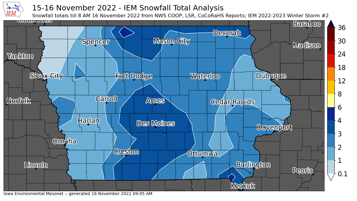
16 Nov 2022 08:38 PMThe featured map is an attempt to produce an estimate of snowfall reports from the second snow storm that impacted Iowa on Tuesday and into Wednesday. There is a major caveat in that some of this snow over northwestern and northcentral Iowa was likely counted within yesterdays map, since the events overlapped the typical 24 hour reporting period. Additional snow is also still falling this Wednesday, but is expected to be very light except over portions of extreme eastern Iowa. While the snow on Tuesday was not too bad to deal with thanks to warmer temperatures close to freezing, today is a different story with temperatures well below freezing and a more difficult process to keep roads clear with some blowing snow happening as well. Regardless of all these caveats, a good chunk of the state received two to four inches of snow and a full blown taste of winter after temperatures in the 70s just last week!
Voting:
Good: 12
Bad: 1
Tags: winter2223
'22-'23 Winter Storm #1
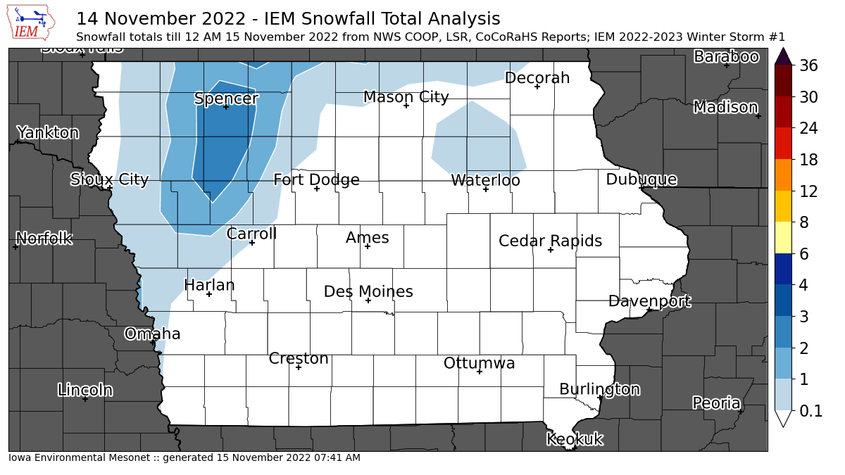
15 Nov 2022 07:47 AMEach year the IEM Daily feature attempts to document snowfall totals from individual storm events. The informal policy is for a storm to produce at least two inches of snow and/or create significant travel impacts. While some parts of Iowa have seen light snow prior to yesterday, totals were very light from those events and thus not counted here. This first significant snowfall event of the season is a tricky one as the second event is already here this Tuesday morning and thus some of the 24 hour reported snowfall totals covered parts of both storms. So some care was taken with the featured map to exclude those totals covering the second storm from this map. Caveat emptor... So the highest totals from the first wave according to available NWS COOP, Local Storm Reports and CoCoRaHS reports were confined to northwestern Iowa.
Voting:
Good: 16
Bad: 0
Tags: winter2223
