Past IEM Features tagged: winter1617
The IEM generates per winter storm analyses of snowfall reports over Iowa and tags them by the winter season. Here are the tags used for the previous winter seasons that these maps are available for:
- Winter 2010-2011
- Winter 2011-2012
- Winter 2012-2013
- Winter 2013-2014
- Winter 2014-2015
- Winter 2015-2016
- Winter 2016-2017
- Winter 2017-2018
- Winter 2018-2019
- Winter 2019-2020
- Winter 2020-2021
- Winter 2021-2022
- Winter 2022-2023
- Winter 2023-2024
- Winter 2024-2025
- Winter 2025-2026
'16-'17 Winter Storm #11
13 Mar 2017 08:18 AMWinter returned this past weekend to Iowa with two rounds of snow impacting the state. The first on Friday evening left just a dusting to about an inch and quickly melted away on Saturday. The second round on Sunday and into Monday packed a much heavier punch with totals approaching a foot of snow in a few limited areas. The featured chart displays an analysis of snowfall reports received thus far. It is still lightly snowing in the state this morning, so totals over southern Iowa may be increased when this map is updated Tuesday morning. This storm system is expected to merge with another system over the northeastern US and create a blizzard for the I-95 corridor.
Voting:
Good: 14
Bad: 1
Abstain: 1
Tags: winter1617
'16-'17 Winter Storm #10
25 Feb 2017 09:07 AMOur week of late spring-like weather was abruptly shifted back to winter with storm system that brought snowfall totals approaching a foot over limited portions of north central Iowa. Blizzard conditions were also observed with many traffic accidents resulting. The featured map displays an analysis of available NWS COOP, Storm Reports, and CoCoRaHS reports. Almost all of the snowfalls this season have dumped the heaviest totals over north central Iowa.
Voting:
Good: 18
Bad: 0
Abstain: 2
Tags: winter1617
'16-'17 Winter Storm #9
09 Feb 2017 07:49 AMA snow storm finally produced snow in the state for areas other than northern Iowa. The featured map displays an analysis of snowfall reports showing an area with 4+ inches over southwestern and west central Iowa. This snow looks to be short lived as much warmer air returns to the state tomorrow with temperatures expected well above freezing. The mild weather looks to continue into next week.
Voting:
Good: 8
Bad: 0
Tags: winter1617
'16-'17 Winter Storm #8
25 Jan 2017 08:00 PMIt had been over a month since we've seen a significant snow producing winter storm in Iowa! The featured analysis of NWS COOP and Local Storm Reports shows the heaviest totals around 12 inches near the Minnesota border. The snowfall totals dropped off as one travels south in the state with Des Moines picking up an inch or so. Strong winds and below freezing temperatures are making for icy road conditions this evening.
Voting:
Good: 12
Bad: 0
Tags: winter1617
'16-'17 Winter Storm #7
17 Jan 2017 05:33 AMThe most significant ice storm to hit Iowa in a number of years is thankfully mostly over. The featured map is an attempted analysis of freezing rain accumulation reports provided by the NWS Local Storm Reports. Please note that areas in northern Iowa are heavily estimated and smoothed due to lack of reports. Hopefully more reports come in on Tuesday and an updated map can be generated. Temperatures are expected to warm this week, which should help to melt most of this recent ice.
Voting:
Good: 10
Bad: 0
Tags: winter1617
Just a dusting
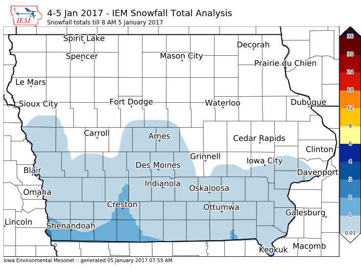
05 Jan 2017 08:02 AMA fast moving system brought just a dusting of snow for most of southern Iowa overnight. Totals approached an inch near the Missouri border. As an administrative note, the tallied IEM 'Winter Storms' of the season have an arbitrary requirement of two inches of snow or significant impacts. So we won't be counting this as a season storm!
Voting:
Good: 9
Bad: 0
Tags: winter1617
'16-'17 Winter Storm #6
24 Dec 2016 07:37 AMJust in time for Christmas for some, 1-4 inches of wet snow fell over Iowa on Friday. Given the holiday season, actual reports were a bit sparse that went into this map. If more reports come in today, the map will be updated later. Some of this snow will have a difficult time sticking around as much warmer temperatures will surge into the state on Christmas Day.
Voting:
Good: 9
Bad: 1
Tags: winter1617
'16-'17 Winter Storm #5
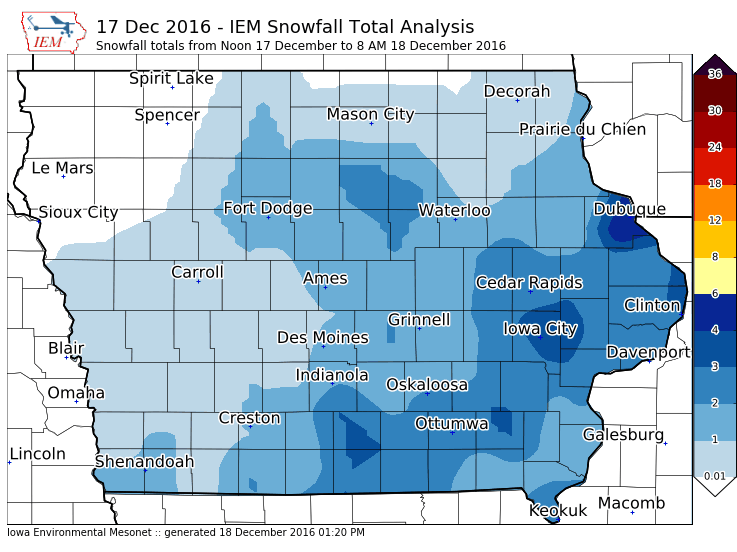
18 Dec 2016 01:24 PMThe featured map attempts to display snowfall totals from the second round of snow for this weekend. Some of the reports may contain totals that were also contained in yesterday's featured snowfall map for storm #4, but in general snowfall totals of a few inches were confined to the southeastern half of the state whereas the largest totals from the first round were near the Minnesota border. While the snowfall was not equally distributed over the state, the bitter cold and dangerous wind chills were shared by all Iowans. Thankfully warmer temperatures are expected for the rest of this week.
Voting:
Good: 10
Bad: 0
Tags: winter1617
'16-'17 Winter Storm #4
17 Dec 2016 04:53 PMThe featured map displays reported snowfall totals from the first round of snow that fell Friday into Saturday morning. The heaviest totals were over northern Iowa, but freezing rain / drizzle was reported as well over areas receiving lesser totals. More snow fell on Saturday and will continue into the evening / early Sunday. Another map will be produced tomorrow showing snowfall total reports from this round of snow. The main concern now is that this snow will blow around and along with extremely cold temperatures create dangerous conditions to be outside.
Voting:
Good: 2
Bad: 1
Tags: winter1617
'16-'17 Winter Storm #3
11 Dec 2016 08:47 PMThe most recent snow storm event came in a number of waves. The featured map displays estimated totals from the entire event over the weekend. The highest totals shifted a bit further north than expected with a few reports over six inches near the Minnesota border. Temperatures warmed a bit on Sunday allowing for some melting to occur. Brutally cold air will push into Iowa on Monday and stick around all week.
Voting:
Good: 11
Bad: 0
Tags: winter1617
'16-'17 Winter Storm #2
05 Dec 2016 07:38 AMThe first snow storm to impact most of Iowa arrived over the past weekend with the highest totals appraching 8-10 inches found near Davenport. Air temperatures did not dip much below freezing and are above freezing over some locations that received snow yet this morning making for less significant travel impacts. Temperatures are expected to warm today, which should melt the snow for most Iowans.
Voting:
Good: 11
Bad: 0
Tags: winter1617
'16-'17 Winter Storm #1
21 Nov 2016 05:34 AMIt took a while for winter like weather to arrive in Iowa this fall, but our first snow producing storm of the season is in the books. The IEM Daily Feature attempts to document the snowfall totals from these events and sequentially numbers them over the season. Having about two inches of snow and/or significant impacts are an informal rule before numbering a storm event. These analyses combine available NWS COOP, CoCoRaHS, and NWS Local Storm Reports. Upwards of six inches are shown on this map over portions of extreme northwestern Iowa.
Voting:
Good: 9
Bad: 0
Tags: winter1617


