Past IEM Features tagged: snowcover
Warming Impact of Snow
18 Jan 2024 05:30 AMWhen considering the impacts of snow, the first thing you think of is not likely warming. For the near surface soil, the impact is often warming as illustrated by today's featured chart. The chart presents a time series of soil temperature at depth from an ISU Soil Moisture Network site near Ames. While this chart does not present snow information, the impact of the introduction of snow cover last week is readily apparent with the immediate cessation of temperature variability. How can it be that soil temperatures warmed with frozen snow over top the ground? Snow cover acts like a blanket to prevent most soil heat from escaping into the air, so warmth at deeper depths is able to warm shallower depths. The chart does show cooling though on the 14th when bitterly cold air temperatures allowed the snow to drop in temperature as well, which overwhelmed any positive warming that was previously happening when the snow was at a higher (but still below freezing temperature). The slightly warmer air temperatures on Wednesday can be seen at the tail end of this plot as again, snow temperatures warmed as well. The presence of snow cover is critical during periods of extreme cold air temperatures in Iowa as plants, pathogens, and other soil residents that perhaps are killed at extreme cold temperatures are saved by the mitigating impacts of the snow cover.
Voting:
Good: 17
Bad: 0
Abstain: 1
Tags: snowcover soil
Big Difference for November
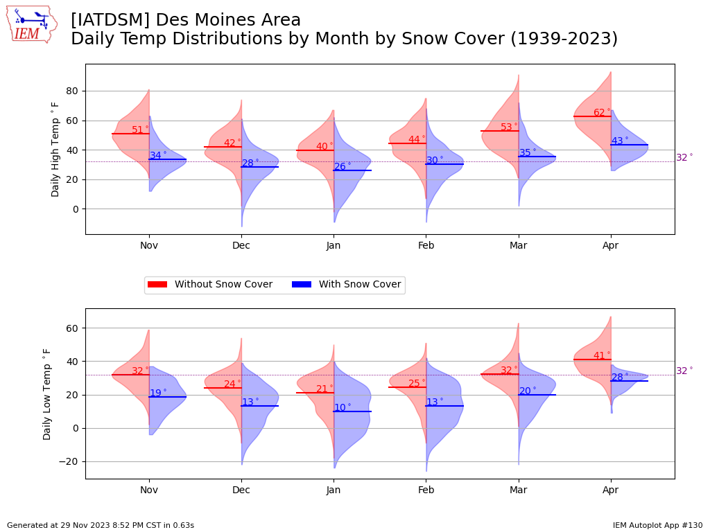
29 Nov 2023 08:57 PMA few days ago, a map was featured showing the afternoon temperature difference for locations with and without snow cover. Of course, the presence of snow cover makes a significant difference in near surface air temperatures as highlighted by today's featured chart. The chart plots the monthly distribution of daily high and low temperatures partitioned by the reported presence of snow cover. The difference for the bookend months of the cold season for November and April are the largest as soil temperatures are generally warmer and can help support warmer temperatures when snow is not present.
Voting:
Good: 9
Bad: 0
Tags: snowcover
NOAA20, Snow cover, and High Temps
27 Nov 2023 09:58 PMThe recently fallen snow cover had a significant impact on Monday air temperatures as illustrated by the featured map. The map combines NOAA20 true color imagery via NASA with NWS COOP locations reporting snow cover (blue dots) and daily high temperatures from airport weather stations. The impact of the stripe of snow over Kansas, Iowa, and into Illinois is readily apparent with warmer temperatures on either side. This snow cover is not expected to last long with winds switching to the southwest by Wednesday, allowing warmer air to advect into the state.
Voting:
Good: 20
Bad: 0
Tags: snowcover satellite
Away Goes The Snow
18 Apr 2023 05:30 AMThe accumulated snow from Sunday into Monday did not stand much of a chance against warmer air temperatures, warm soil temperatures, and sunshine on Monday. The featured webcam lapse is from the KCRG-TV CityCam in Fayette (northeastern Iowa) and nicely shows the snow melting away as the day progresses. Temperatures will continue to recover this week until another strong shot of cold weather arrives for the weekend. At this point, it seems a hard freeze (temp below 29) is likely over much of the state Saturday Night.
Voting:
Good: 11
Bad: 0
Tags: webcam snowcover melting
Recent Snow Mostly Gone
21 Feb 2023 05:30 AMThe big snowfall of last week didn't last very long thanks to increasingly effective sunshine and warm temperatures. The featured chart presents a heatmap of daily snow depth reports for Des Moines for each winter since 2000. The year's are labelled by the year of the associated fall/winter season, so this year's values are found labelled 2022. The most recent white boxes for 2022 show the snow be reported as gone for Des Moines. It is fun to compare the various years as the depth and duration of the snow cover vary wildly by year. The winter's of 2000-2001 and 2009-2010 are remarkable compared with other winters like 2016-2017.
Voting:
Good: 10
Bad: 1
Tags: snowcover
Snow Cover Temp Difference
28 Nov 2022 05:30 AMFor late November, our recent stretch of weather, including the Thanksgiving holiday, has been quite good. The absence of snow cover during this period has certain helped and allowed day time temperatures to warm nicely into the 50s. The featured chart presents daily high and low temperature distributions by month and partitioned by the presence of any snow cover. There are caveats galore to a plot like this as the snow cover report timing with the daily high and low temperature is not an exact science. That aside, the difference between the two distributions is quite clear and especially large during the early and late months of the cold season.
Voting:
Good: 11
Bad: 0
Tags: snowcover
Snow Period Ending
12 Jan 2022 05:32 AMTemperatures nicely soared on Tuesday to the warmest values seen so far this year with highs in the 40s and 50s. Due to the lack of snow cover there, Sioux City was able to set a new record high temperature for the date of 58 degrees. The warm air is expected to stick around a few more days and will make quick work of the remaining snow cover over the state. The featured chart presents a daily analysis of areal coverage of snow depth of at least an inch over Iowa. Today's value will post later today on this chart and likely show not much left. In general, amounts have been meager this winter season with a very late start to the first significant snowfall and then a period of warm weather during December. You snow lovers take heart as the forecast models continue to advertise a significant snowfall later this week. The rest of you should enjoy these warm temperatures while they last!
Voting:
Good: 16
Bad: 0
Tags: snowcover
Snow Cover and Highs / Lows
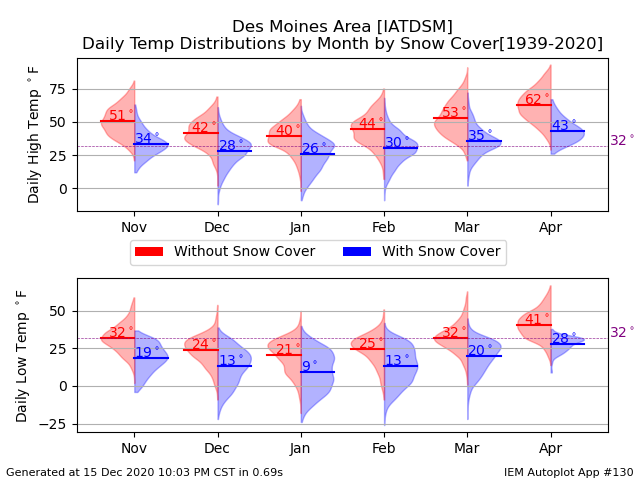
16 Dec 2020 05:36 AMTemperatures continue to struggle a bit this week with plenty of snow cover around. The presence of snow certainly makes a difference to near surface air temperatures we experience. The featured chart presents the daily high and low temperature distributions by month on days without and with snow cover for Des Moines. The distributions are presented in the form of violin plots with each half violin representing a smoothed kernel density estimate at the given temperature. The wider portions of the violin represent higher frequencies. Each distribution has its mean marked and labeled. So the plot clearly shows the negative impact for temperature when snow cover is present. For December, the difference is the upper 20s with snow to lower 40s without.
Voting:
Good: 15
Bad: 0
Tags: snowcover
Snow Cover and Lows
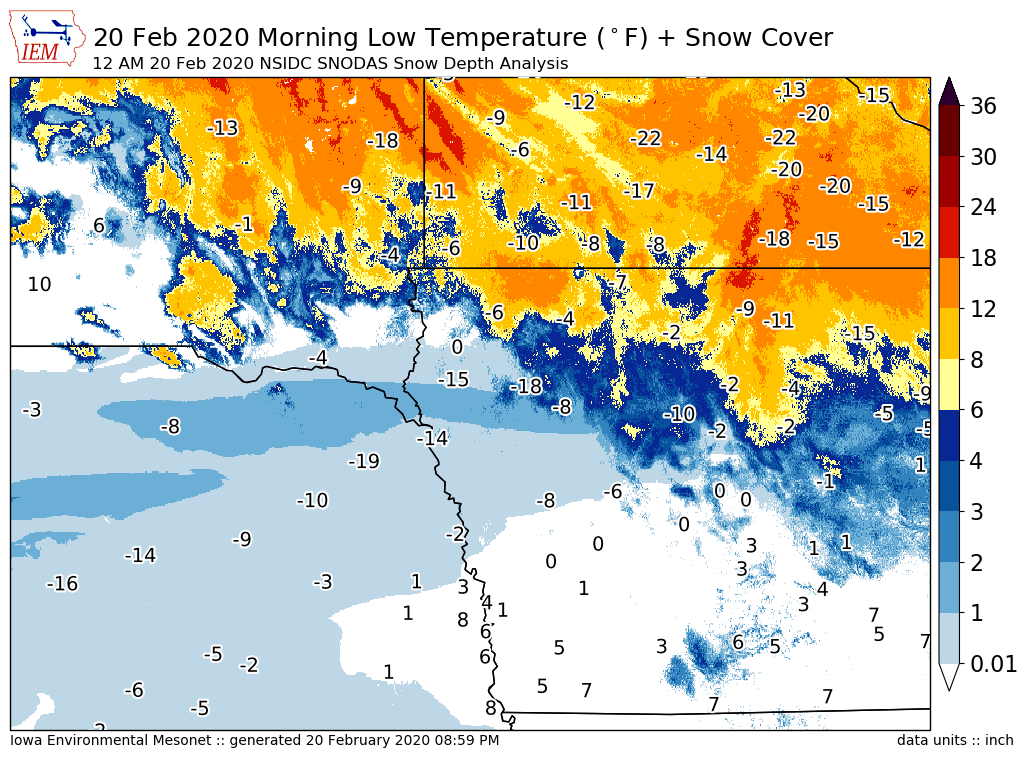
21 Feb 2020 05:33 AMA strip of newly fallen snow and ideal atmospheric conditions for cooling conspired to create major local differences for low temperature on Thursday morning. The featured map presents the combination of morning low temperature reports for airport weather stations along with a grid analysis of snow depth from the National Snow Ice Data Center. The map is centered on western Iowa and the local differences between areas with snow and without snow cover is readily evident. Snow cover is an efficient emitter of "long wave" radiation at night time and without clouds, the air close to this surface has little hope of staying warm!
Voting:
Good: 22
Bad: 3
Abstain: 2
Tags: snowcover
Had more snow cover in November
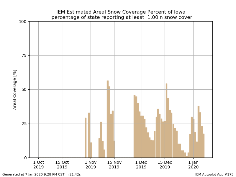
08 Jan 2020 05:34 AMBased on a simple spatial analysis of available NWS COOP snow depth reports, the featured chart presents an areal estimated coverage percentage of snow depth of at least one inch for Iowa. Only a few brief days this winter season have shown values above 50% and we've seen much larger coverage back in November than we do now in January. Of course, the main snow producing part of the winter season has yet to come (March + April).
Voting:
Good: 11
Bad: 0
Tags: snowcover
Deep Snow for November
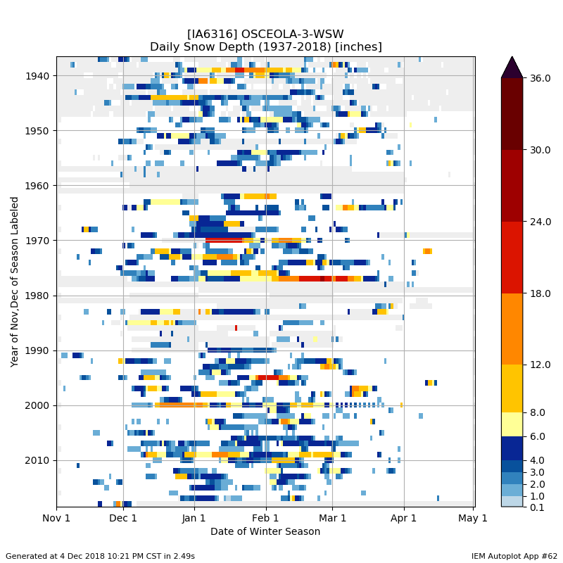
05 Dec 2018 05:34 AMThe featured chart depicts daily snow depth reports from Osceola (just south of Des Moines). Each horizontal line of data represents the given winter's reports. The bottom line represents the present winter season with boxes in gray denoting missing reports. The recent big snowfall to end November really sticks out for the site compared with all other Novembers on record. Even when considering the entire winter season, you have to go back to 2009 to find comparable snow depths.
Voting:
Good: 10
Bad: 0
Tags: snowcover
With and Without Snow Cover
09 Nov 2018 05:34 AMThe presence of snow cover makes a tremendous difference in observed temperatures. The featured chart looks at the average high and low temperature by month partitioned by the presence of snow cover. For November, the difference is a whopping sixteen degrees for high temperature. The snow that is falling today will likely not stick around long, but temperatures will still be quite cold for the coming days. Highs will struggle to reach above freezing even without much snow covering the ground.
Voting:
Good: 7
Bad: 0
Tags: snowcover
Rule of 43
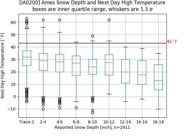
14 Feb 2018 05:33 AMHigh temperatures are expected to soar to levels of warmth you should express to your significant other today. But how warm can it get with deep snow cover existing over much of the state? A local forecasting rule of thumb is to not forecast a high temperature over 43 degrees when there is at least four inches of snow depth to start the day. Does this rule hold against long term observations? With a bunch of caveats with how daily snow depth and high temperatures are reported, the featured chart depicts binned box plots for a given snow depth and the following day high temperature. So in general this rule mostly holds, but there are a few observations shown above the 43 degrees and four inch depth. Of course, the reason for this rule is energy is consumed by melting available snow that would otherwise go into heating the air.
Voting:
Good: 13
Bad: 0
Tags: snowcover highs forecasting
Snow Cover About Gone
16 Feb 2017 05:35 AMAfter the epic warmth expected today, you'll be hard pressed to find meaningful snow cover in the state. The featured chart displays areal coverage estimates of having at least one inch of snow on the ground this winter season. The snow cover left this morning is relegated to north central Iowa. The current forecast does not have much hope for a return of snow until at least late next week.
Voting:
Good: 9
Bad: 1
Tags: snowcover
Few Days of Snow Cover
10 Feb 2017 05:37 AMThe snow that fell this week over the southern half of Iowa is not expected to last long as warm air returns in full force on Friday. The featured chart displays daily snow depth reports for Des Moines since 2000. The row representing the 2016-2017 season shows very few days with reported snow cover. Kind of interesting to compare this winter with the more extreme years of 2009-2010 and 2000-2001. The near term forecast does not hold much hope for a return of snow for the next seven days.
Voting:
Good: 20
Bad: 0
Tags: snowcover
Snow Cover Impact
07 Dec 2015 05:34 AMIt stands to reason that having snow cover makes a big difference in what air temperatures can be expected. The current stretch of mild weather is thanks to a mostly snowless Iowa. The featured chart displays the monthly average daily high and low temperatures partitioned by the presence of snowcover reported on the same day as the temperatures. There are some caveats to this plot given the timing of temperature and snowcover reports, but the impact is clear. While our current high temperatures are above average, they are not too far from what we'd expect on days without snow cover.
Voting:
Good: 14
Bad: 4
Abstain: 3
Tags: snowcover
Obvious Relationship
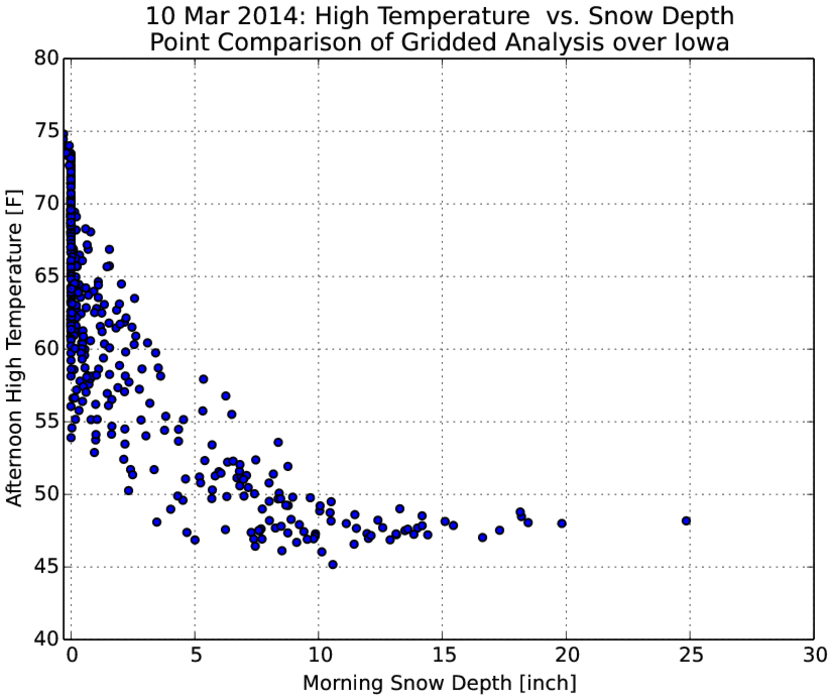
11 Mar 2014 05:37 AMAfter a wonderful Sunday, Monday was able to top it with temperatures soaring to levels not seen since last year. Sioux City was able to tie a record high temperature of 74 degrees. Not all of the state was able to get that warm and the sole reason was the deep snowpack that still exists over much of northeastern Iowa. The featured chart shows the obvious relationship between morning snow cover and the afternoon high temperature over Iowa for Monday. A forecasting rule of thumb states that the high temperature can not exceed 43 degrees when there is at least four inches of snow depth present in the morning, but this rule does not hold when significant warm air advection is happening. Warm air advection is the process of moving warmer air into areas with colder air. This warm air from the south helps to push temperatures even warmer.
Voting:
Good: 24
Bad: 11
Abstain: 6
Tags: snowcover
Snow Cover and Highs
19 Feb 2014 05:41 AMTuesday was a welcome relief from winter with nearly the entire state reaching 40+ degrees for a high temperature. The feature chart presents the afternoon high temperature vs the reported snow cover depth yesterday morning. This comparison is made between a grid analysis of both observed variables. The relationship is clear with areas with the least amount of snow having the warmest temperatures. The snow free areas in western Iowa were able to reach the 60s! Our winter relief will not last long as Iowa gears up for an expected blizzard on Thursday.
Voting:
Good: 25
Bad: 5
Abstain: 3
Tags: snowcover
Colder with snow cover
11 Dec 2013 05:45 AMThe featured chart shows the daily averaged difference in temperature between days with snow cover and with out. The temperature difference is for the next seven days after the analyzed date. The chart is attempting to show the temperature effect when there is snow cover versus not. The approximate average of the chart is negative five degrees, meaning that the presence of snow cover on a given winter day produces, on average, a next seven day period that is five degrees cooler than the same period when the first day is snow free. The results are intuitive as snow cover helps temperatures cool more rapidly at night and prevents incoming sunshine during the day from heating the ground. Our weather is going to remain very cold with our current snow cover that is being added to this morning with our most recent round of winter weather.
Voting:
Good: 31
Bad: 6
Abstain: 8
Tags: snowcover
White till Christmas?
10 Dec 2013 05:45 AMWith the ground covered in snow and freezing temperatures in the forecast, could our current snow cover make it to Christmas Day? The featured chart presents the duration of snow cover when it was present on 9 December for Des Moines. Christmas is shown at 50%, meaning that half of the years with snow cover on the 9th had that snow stick around until Christmas. 25% of the the years had the snow stick around until the first of February even! Winter is in firm control of our weather with even colder weather expected tomorrow.
Voting:
Good: 23
Bad: 2
Tags: snowcover
Snow Cover and Cold Lows
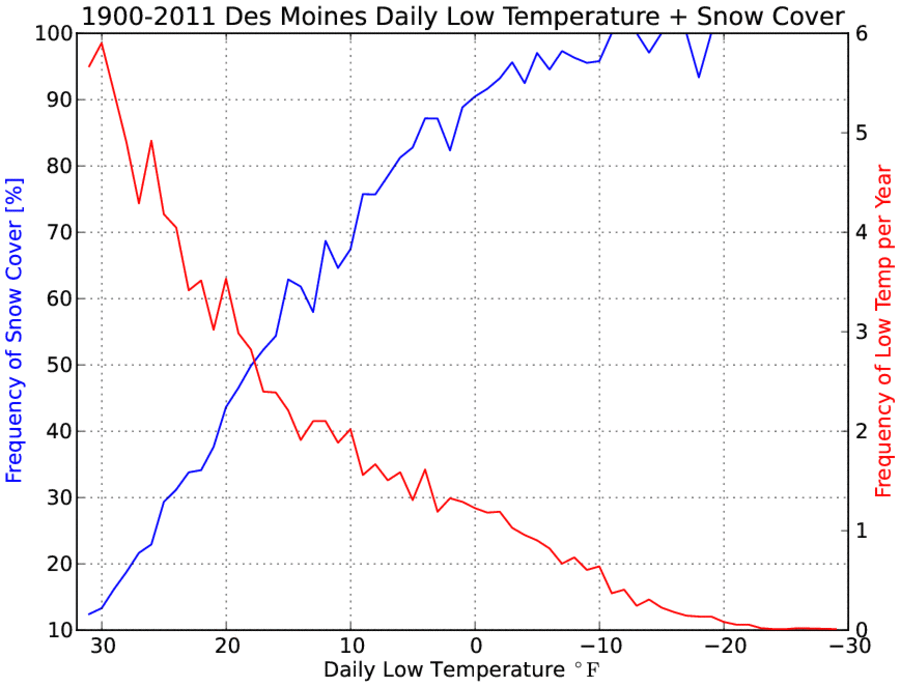
27 Nov 2012 05:39 AMTemperatures dropped quickly Monday evening thanks to clear skies and calm conditions. Our saving grace was ground temperatures which are still warm for this time of the year and the lack of snow cover, which prevented temperatures from dropping even further. Snow cover is a game changer when it comes to the surface energy balance during the day and night time. It acts to mostly seperate the exchange of energy from the sun to the soil and back to the air. The featured chart presents the frequency of having snow cover at a given daily low temperature (blue line) and the overall frequency of that temperature (red line). The main point is to show that the coldest temperatures are increasing associated with the presence of snow cover. For example, a low temperature of zero degrees also had snow cover present 90% of the time. The chart also had an interesting (but unexplained here) aspect of having the lines cross at the 50% probabilities for both y-axes around 18 degrees. It is difficult for near surface soil temperatures to get cold enough to support very cold air temperatures, so snow cover is increasing necessary for the coldest temperatures.
Voting:
Good: 40
Bad: 7
Tags: lows snowcover
Snow and no snow
16 Jan 2012 05:48 AMThe high temperature you experienced on Sunday in Iowa was very dependent on the amount of snow you received from our storm last week. Warm air surged into the state, but thanks to snow cover over eastern Iowa temperatures were much cooler than the mid 50s over western Iowa. This contrast is nicely shown by overlaying high temperatures on Sunday to visible imagery showing areas with and without snow. The forecast for this week looks to be active with another warm up expected next weekend.
Voting:
Good: 25
Bad: 5
Tags: snowcover satellite
White Christmas Influence
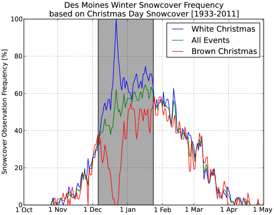
23 Dec 2011 05:58 AMThe featured chart presents the observed daily frequency of snowcover partitioned by if there was snow cover on Christmas and the overall average is shown. The highlighted area shows the period were these three lines show visual differences, which is a way to show the memory of having a white or brown Christmas. In other words, by mid February the frequency of having snow cover does not relate to if we had snow cover on Christmas. Back to the matter at hand of our snow state for this Christmas, well it will be brown with very warm temperatures in the 40s!
Voting:
Good: 25
Bad: 14
Tags: snowcover christmas
Warmer March in store?
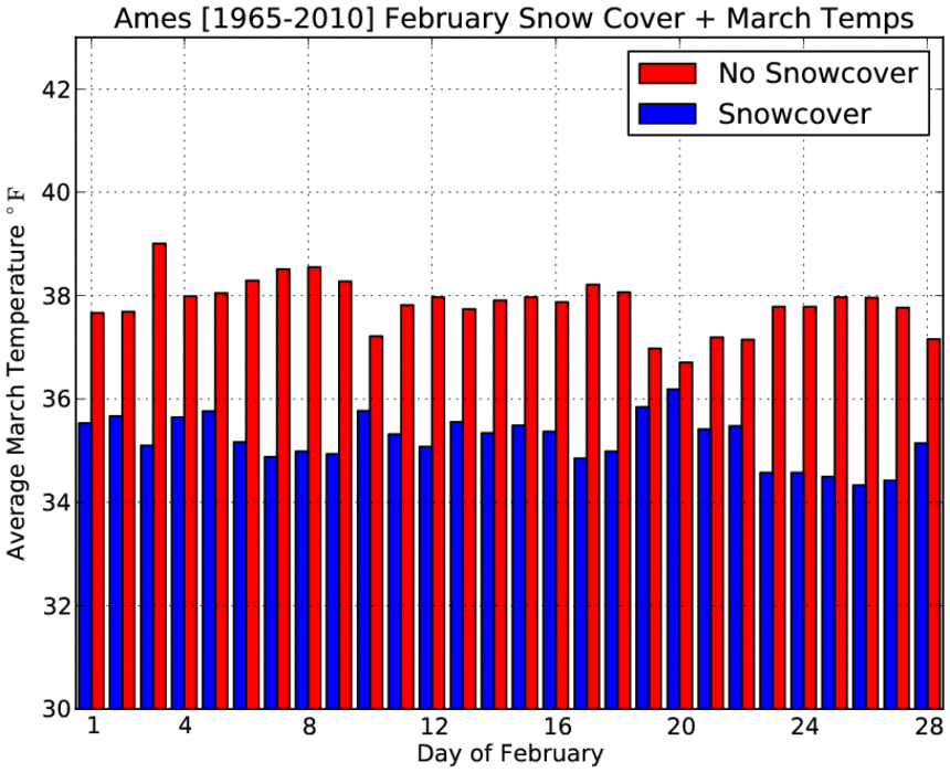
15 Feb 2011 05:55 AMThe past few days of much warmer weather has helped to eliminate much of the snow that has stuck around for most of winter. The featured chart looks at the relationship between having snow on the ground of a given day in February and then the average temperature that following March. The implication is clear, getting rid of the snow now leads to a few more degrees warmer weather in March. The chart also shows that the coldest, on average, March temperatures are when there is snow at the end of February and the warmest are when there is no snow at the beginning of the month.
Voting:
Good: 13
Bad: 6
Tags: snowcover feb mar
Snow brings the cold
20 Jan 2011 05:50 AMThe average temperature so far this month is about 5 degrees below normal for Ames with each day having snow cover so far. The featured chart presents the relationship between observed average temperature departure and number of days with snow cover for January. While the linear fit is not perfect, the relationship is fairly clear. The preliminary value so far for 2011 is shown by the plus symbol. The chart shows the coldest five months all having snow cover for 30 or 31 days.
Voting:
Good: 16
Bad: 6
Tags: snowcover jan
The hindrance of snow
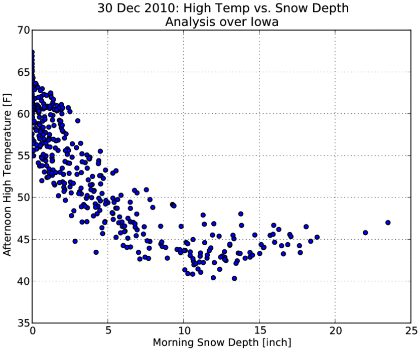
03 Jan 2011 05:47 AMTemperatures soared last Thursday (30 Dec) pushing 60 degrees for Des Moines. Not all Iowans were as lucky with those in north-eastern Iowa only in the mid 40s. The primary reason was the deep snow pack that existed prior to the strong push of warm air into the state. The featured chart presents an analysis of high temperature versus the snow depth present that morning. The relationship is clear! A common forecasting rule says the high can only reach 43 with 4+ inches of snow on the ground, the push of warm air was exceptionally strong which is why this rule didn't quite hold.
Voting:
Good: 26
Bad: 5
Tags: snowcover
Does the first snow stick around?
08 Dec 2010 05:47 AMWith folks in Ames and Des Moines anxiously waiting for our first snowfall of the season, one may wonder how long our new snowfall will stick around? The featured chart presents the date and amount of the first snowfall for Ames of the winter season. The dot's color represent how long measurable snow depth was observed after the initial snow fall. Last year, our first snow fall (around this date) stuck around until mid March! Most of the dots are in the 1-7 day range, so perhaps our first taste of snow will be brief like most years!
Voting:
Good: 16
Bad: 2
Tags: snowcover snow
A repeat of last winter?
07 Dec 2010 05:47 AMThe forecast for the coming weekend looks to bring accumulating snow to central Iowa for the first time this season. The featured chart presents the daily snow depth reported near Ames for the previous winter seasons since Nov 1964. Last year certainly sticks out on this chart with deep snow throughout much of February. One also notes that once the snow arrived during the second week of December, it stuck around until mid March! Are we set to repeat this pattern?
Voting:
Good: 22
Bad: 5
Tags: snowcover 2009
Cold even without snow
06 Dec 2010 01:17 AMFor those of us in central Iowa still without snow, these very cold December days are typically what you would expect with snow on the ground. The featured chart presents the difference in daily high and low temperature when there was and was not snow on the ground. The cold weather will continue this week with a warm up to just above freezing not expected until the end of the week along with a chance of snow.
Voting:
Good: 24
Bad: 4
Tags: snowcover
Snow cover probabilities
19 Feb 2010 06:13 AMThe featured chart looks at the probability of having snow cover on a day during the winter contingent on having snow cover for a given date. Confused? In other words, if there is snow cover for this date, how likely was there also snow cover on March 1rst or December 25th of that same winter. One of the disappointing aspects of the chart are the clear month boundary effects as often the data was manually quality controlled a month at a time (the end of one month doesn't match the beginning of the next). The second week of March shows up nicely as an elevated chance of snow cover, but those events can then be associated with elevated probabilities in mid January.
Voting:
Good: 30
Bad: 26
Tags: snowcover climate
How long will this take?
18 Feb 2010 06:10 AMThe featured chart plots the number of days it takes for a given snowfall depth to disappear. The depth is the maximum reported value during a period of snow cover. Rephrasing, how long does it take to get rid of the snow once we reach a local maximum of depth. If you hope that our last snowfall peaked our snow depth around 15 inches here in Ames, the chart would hint that perhaps we have another 30 days left before the snow disappears. Not good news. The dataset is separated by time of year and you can see the spring events (March-May) have a very short duration, which makes sense as temperatures are warming and solar angle increasing.
Voting:
Good: 23
Bad: 8
Tags: snowcover
Snow for everybody
15 Feb 2010 05:07 AMThe featured map is from the excellent NOAA NOHRC website showing snow water equivalent from Friday evening. The map shows every state in the lower 48 with some snow cover even the panhandle of Florida! Not shown are Hawaii and Alaska. While Alaska surely has snow cover now, it took a bit of detective work by Patrick Marsh to find snow in Hawaii. Regardless, it has been an exceptional winter for snow and more snow is currently falling and blowing in Iowa today.
Voting:
Good: 23
Bad: 11
Tags: snowcover
When there is snowcover on Christmas...
21 Dec 2009 06:10 AMThe featured chart looks at the daily frequency of having snowcover around the dates when there was an inch or more of snowcover on Christmas Day. Just as people wait until the last minute to complete shopping, sometimes Mother Nature waits till the last moment to make the Christmas white. The chart would indicate that roughly 20% of the white Christmas events occur due to a snowfall within 3 days of the 25th.
Voting:
Good: 11
Bad: 8
Tags: christmas snowcover
First cold and snow cover
15 Dec 2009 06:08 AMThe featured chart looks at the presence of snow cover during the first fall/winter occurrence of a given low temperature based on data from the Ames COOP station. While having snow cover is not a requirement for really cold temperatures, it certainly is present more often than not for the first temperature below zero of the season.
Voting:
Good: 15
Bad: 6
Tags: snowcover lows
Snow depth changes
26 Jan 2009 06:19 AMThe featured chart is the frequency of daily snow depth changes when there is snow on the ground based on 43 years of data from Ames. During the winter time, the most common thing to happen is no change. This plot would indicate that having the snowpack decrease is more likely than increase. The height of the stacked line chart indicates overall frequency of having snow on the ground. Light fluffy snow is in the forecast for this week, so more green than red for us.
Voting:
Good: 26
Bad: 9
Tags: snowcover
Can tell where the snow is
22 Jan 2009 06:12 AMThe featured map is an analysis of reported snow depth and high temperature on Wednesday. The 32 degree isotherm nicely lines up with the boundary between deep snowpack and bare ground. It will be interesting to see how far into the snow field the warmer air can get today. Deep snow pack tends to create a very shallow layer of cold air that is difficult to mix warm air into or scour out.
Voting:
Good: 24
Bad: 6
Tags: snowcover
How warm can it get today?
26 Dec 2008 09:36 AMThe featured image is a scatter plot of next day high temperatures versus snow depth. The plot tries to answer the question how warm can it get the next day after having snow on the ground today. An old forecasting tip is that high temperatures rarely exceed 43 degrees with 4+ inches of snow on the ground. The 4 inch snow depth reference line on the chart indeed shows very few 43+ degree temperatures. With high temperatures forecasted in the 50s today, this will be exceptionally warm given our current snow pack!
Voting:
Good: 44
Bad: 16
Tags: highs snowcover
Snow cover makes a difference
12 Dec 2008 06:20 AMThe featured chart is of daily average high and low temperatures for Ames based on observations since 1964. The overall average is shown in the faint color. The two other lines for daily highs and lows represent days on which snow cover was or was not reported. The effect of having snow cover is very clear with temperatures always lower on average. The simple reason for this is an increased albedo, which keeps the suns energy from warming the ground which warms our air! If you want warmer weather, get rid of the snow on the ground (chicken and egg process).
Voting:
Good: 49
Bad: 20
Tags: snowcover
Snow Depth Data
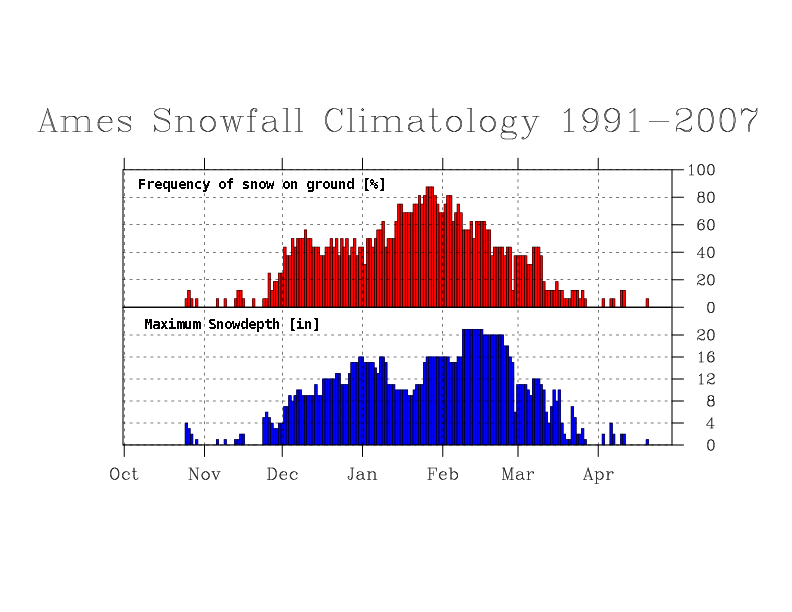
26 Nov 2008 06:13 AMThe featured chart shows the daily frequency of having snow on the ground and maximum snow depth based on data for Ames back to 1991. Based on this plot, the best chance of having snow on the ground is the end of January. The short term forecast does not have snow predicted and the weather on Thanksgiving looks very nice with highs in the 40s.
Voting:
Good: 67
Bad: 36
Tags: snowcover
Any relationship here?
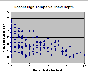
12 Mar 2007 07:39 AMThe featured plot is of daily high temperatures versus snow depths for locations in Iowa this past weekend. There is some ambiguity to the timing of the snow depth and high temperature measurement, but it is close enough for government work. The main point is to show the effect appreciable snow cover has on temperatures. While Southern Iowa enjoyed 60+ degrees on Sunday, most of Northern Iowa struggled in the low 40s.
Voting:
Good: 19
Bad: 3
Tags: snowcover
Influence of snow
15 Dec 2005 07:46 AMThe featured plot charts daily solar radiation (red line) and average 4 inch soil temperatures (black line). Any idea why the black line has been mostly flat for December? The answer is snow! A blanket of snow acts just as that, a blanket. The ground's heat is trapped below and the ground is protected from the cold air above the ground. In fact, the ground remains rather warm which is no surprise for those folks who have been ripping up their yard with the snowplow.
Voting:
Good: 11
Bad: 1
Tags: snowcover


