Past IEM Features tagged: dat

DAT Infographics
06 Apr 2026 05:30 AMThe National Weather Service Damage Assessment Toolkit (DAT) is a post-event storm survey platform that provides information from NWS damage surveys typically following tornado events. NWS Quad Cities / Davenport has completed a couple of such surveys following tornadoes during storms last week. The IEM offers a visualization of the "DAT tracks" that combines NWS Tornado Warnings along with an estimated track timing. The shown tornado tracked just southeast of Maquoketa. There are also Public Information Statements (PNS) associated with these DAT events with this PNS covering this featured tornado. The IEM also maintains a simple google email group that anybody can subscribe to receive emails when the NWS publishes such PNS damage survey results.
Voting:
Good: 16
Bad: 0
Tags: dat tornado
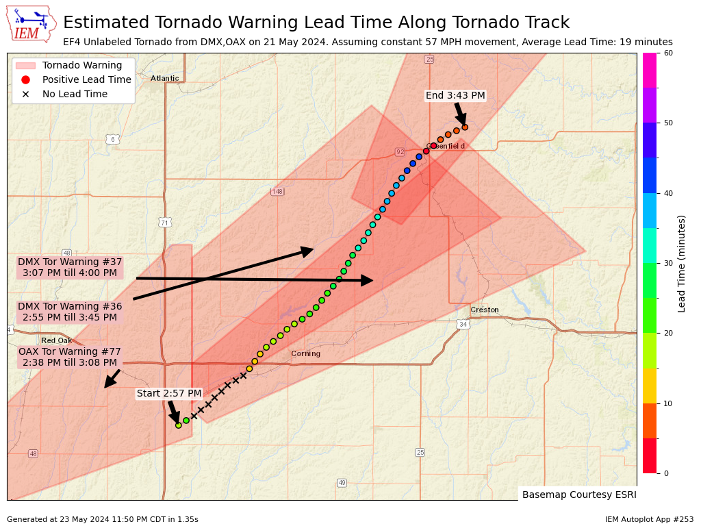
Greenfield Tornado
24 May 2024 05:30 AMYesterday's daily feature map of the Polk/Story Tornado Track from Tuesday was well received, so today's map shows the current and preliminary NWS track for the tornado that hit Greenfield, IA. The map combines NWS Tornado Warnings with the tornado track and attempts to assess lead time at one minute interval points along the track. There are caveats galore with this type of analysis as the algorithm assumes a constant ground speed and has a very rigid and binary spatial/temporal match between the track points and the polygons. For example, the x's indicate times that the tornado was temporally and spatially outside of the warning, but there was an active warning less than 0.5 miles to the west. Additionally, the points near Greenfield are shown with a very short lead time, but previous warnings were within a mile with plenty of lead-time. So for what it is worth, you can now generate these maps on-demand for other tornado tracks found within the NWS Damage Assessment Toolkit (DAT).
Voting:
Good: 33
Bad: 1
Tags: dat may212024