Past IEM Features tagged: smoke
Weekend Wildfire Smoke
02 Jun 2025 05:30 AMThe wildfire smoke from Canada was quite noticeable this past weekend aloft over Iowa with a red/orange tint to the sunlight. Some of the smoke even reached the surface dropping air quality. The featured chart looks into the impact on solar radiation. The chart displays one minute solar radiation from the ISU Soil Moisture site near Crawfordsville (SE Iowa). The smoke aloft was present both days, but the amount / thickness varied. The relatively smooth curves on both days indicates the lack of clouds, which would have made the chart much more noisy. So we find radiation flux intensity differences ranging up to 150 Watts per meter squared. The upper right legend has the day long / integrated total. The radiation total on Sunday was about 10% less than Saturday, which was also below a theoretical clear sky maximum around 32 Megajoules.
Voting:
Good: 8
Bad: 0
Tags: smoke
Summer Visibility Streaks
29 Jun 2023 05:30 AMWednesday was another day of thick smoke over much of the state with conditions again the worst over eastern Iowa. One metric to assess the smoke is surface visibility reports from the airport weather stations. The Cedar Rapids station reported visibility at or below 2 miles starting Tuesday morning and lasted until Wednesday evening making for a streak lasting just over 37 hours. The featured chart presents IEM computed streaks of the site having a visibility of 2 miles or below for at least 16 hours during the summer months. No other streak is to be found lasting even 24 hours, so this current event is very exceptional. Such streaks are much more common during the cold season when low clouds and fog can persist for long periods of time due to limited heating and mixing of the lower atmosphere.
Voting:
Good: 9
Bad: 0
Tags: smoke
Day of Smoke
28 Jun 2023 05:30 AMOutside of the ongoing drought, the biggest weather story this warm season has been the persistent Canadian wildfire smoke that has frequented the state. Yesterday was about as bad as it has gotten so far this year over Eastern Iowa with very poor air quality at the surface. The featured movie is a daytime lapse from the KCRG-TV webcam near the Amana Colonies showing the persistent and at times very thick haze. More of the same is forecast on Wednesday, especially over eastern Iowa again.
Voting:
Good: 9
Bad: 2
Tags: video smoke
Smoke Swirls
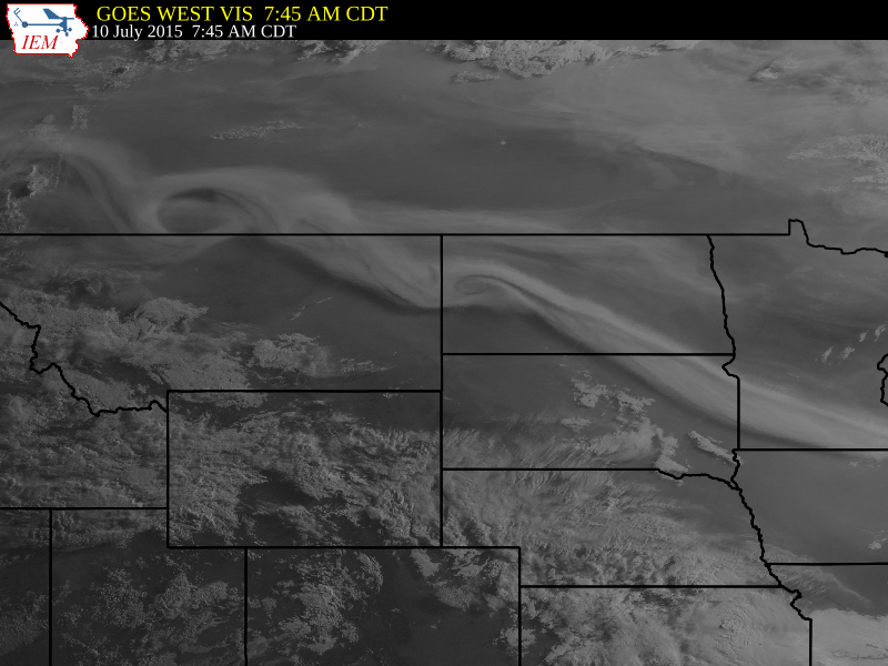
11 Jul 2015 05:48 AMVisible satellite imagery on Friday morning captured swirls in the smoke plume from Canada. These swirls are always present in the atmosphere, but we often can not see them in the cloud formations. Much like how people use tracers in a wind tunnel to see how the air is flowing, the smoke plume was doing a similar thing in the atmosphere.
Voting:
Good: 25
Bad: 11
Abstain: 5
Tags: satellite smoke
Canadian Fires
30 Jun 2015 05:43 AMThe smoke from Canadian wild fires was very noticeable in Iowa on Monday and made for a red colored sun. The featured map is visible satellite imagery with the smoke plume highlighted coming south out of Canada and into Iowa. Our upper air flow pattern looks to maintain this transport, so we may be seeing more of the smoke.
Voting:
Good: 16
Bad: 6
Abstain: 3
Tags: smoke
A Wild Sunday
07 Mar 2005 12:04 AMAfter complaints of March being boring, Mother Nature is working overtime this week to make things interesting. Sunday afternoon was very windy with record high temperatures and then a round of thunderstorms rolled through bringing lightning, small hail, and gusty winds. The highlighted animation shows the smoke plune from a large grass fire in Pottawattamie County. The strong winds and deep mixed surface layer quickly moved this smoke upwards to a reported 15,000 feet. The weather this week looks to be a bumpy ride, so hold on tight!
Voting:
Good: 15
Bad: 6
Tags: smoke nexrad


