Past IEM Features tagged: radiation
Decorah Wins
21 May 2020 02:22 AMTypically being located in the far northeastern corner of Iowa means you experience some of the cooler temperatures within the state. Wednesday was an exception to that generality with Decorah (site id: DEH) reporting the warmest high temperature near 72 degrees. The reason why Decorah was the warmest was the location actually saw significant sunshine whereas the most of the rest of the state was cloudy. The featured chart compares an IEM produced solar radiation estimate based on HRRR model data against the reported high temperature for airport weather stations in the state. Selected sites are labeled by their station identifier. The relationship between the two variables is clear with increasing sunshine leading to warmer temperatures.
Voting:
Good: 10
Bad: 0
Tags: solar radiation
One Minute Radiation
14 Jun 2019 05:33 AMThe featured graph is a preview of some exciting upcoming changes to the ISU Soil Moisture Network. The presented data is one minute interval solar radiation from one of the sites just north of Ames at the Horticulture Farm. The chart overlays the data from Thursday and Wednesday. Can you tell which day had clouds and which barely had any? Once you figure that out, you may wonder how the radiation data is sometimes higher on the partly cloudy than the clear one. The sensor is not tracking the sun attempting to directly measure what comes from the sun, but is sensing total global radiation arriving at the sensor. As such, during convective and partly cloudy days, those bright white clouds you see are scattering solar energy to the sensor and thus increasing the amount of radiation received. There is one other obvious quirk shown in the plot, happening about 5 PM. Can you guess what it is?
Voting:
Good: 19
Bad: 1
Abstain: 1
Tags: radiation
Daily Radiation
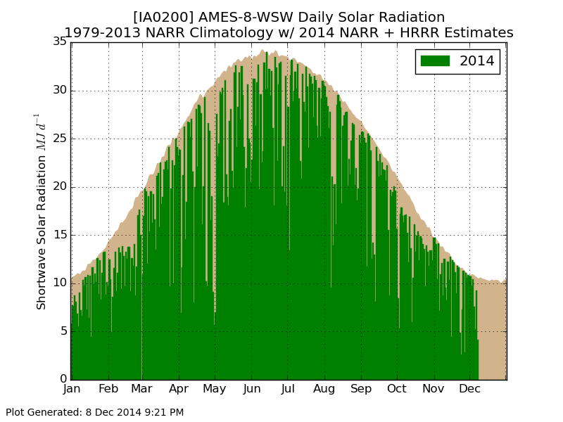
09 Dec 2014 05:41 AMThe featured chart displays model estimates of daily solar radiation for Ames. The brown area represents the maximum potential based on long term estimates from the NARR model. The green area represents what was estimated for this year. Since there is an availability lag of the NARR data, a short term weather model (HRRR) is used to supplement this gap allowing for estimates up until yesterday. While the daylight time and solar declination changes are easily noticeable for this time of year, the actual difference in solar energy received is some 3-5 times less than what we get during the summer time. This energy difference makes it much more difficult to warm the ground during the winter time and thus warm the air. Recently, we have also had plenty of clouds, which has further limited the amount of radiation received. For warming to occur this time of year, we need help from the transfer of warmer air masses to our south into Iowa.
Voting:
Good: 16
Bad: 4
Abstain: 3
Tags: radiation
Solar Radiation
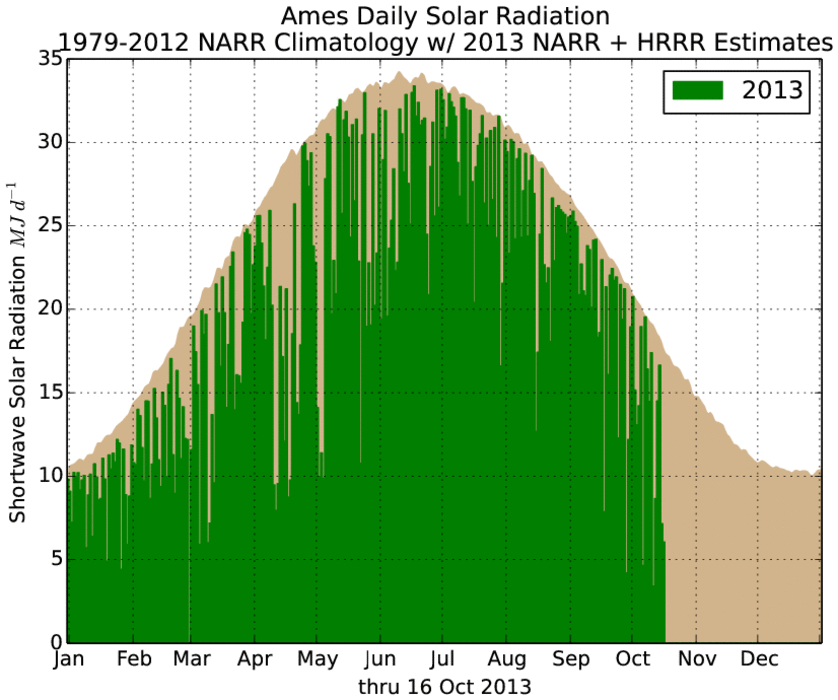
17 Oct 2013 05:37 AMMuch of Iowa has been struggling to see the sun these past few days and so temperatures have been struggling as well. When the sun is seen, the ground is typically experiencing the potential maximum amount of energy received for that day and time of the year. This produces heating that drives our near surface air temperatures warmer during the daylight hours. The featured chart presents one model's estimate of daily maximum shortwave solar radiation received at the surface and what actually happened this year. You can consider the tan area showing up until today as the effect of clouds. The last two bars in the chart show the minimal amount of solar radiation experienced by Ames for the past two days. An increase in sunshine is expected today, which will help warm temperatures out of the 40s and 50s we've been stuck in.
Voting:
Good: 47
Bad: 7
Tags: radiation
Afternoon clouds
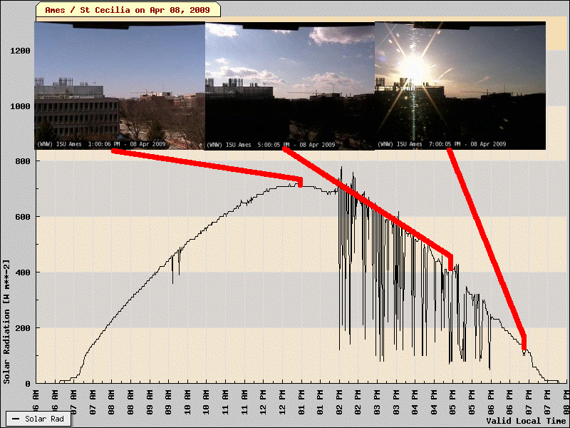
09 Apr 2009 05:58 AMThe featured graph and images are from the Ames SchoolNet Site and Webcamera. The time series is of instantaneous solar radiation sampled every minute. Notice how the curve transitions from smooth to choppy in the afternoon and then smooth again just before sunset. The shape of this curve tells the story shown in the featured 3 webcam images, a transition from clear skies to party clooudy to mostly clear at sunset. The solar radiation curve becomes choppy as the sun plays peekaboo with the clouds as opposed to being a pure function of location in the sky during optically clear situations.
Voting:
Good: 23
Bad: 6
Tags: sun radiation
Radiative fun at 5 AM
11 Jan 2007 12:13 AMThe featured graph has a lot going on. The three data lines are from the NSTL Flux site near Ames for Tuesday morning. The green line is long wave radiation and simply shows the period up until 5 AM which was cloudy (clear sky values are around -100 W m**-2). The orange line is short wave (solar) radiation and its obviously near 0 until sunrise around 8 AM increasing to around 400 W m**-2 at midday. The air temperature trace in red shows three distinct regimes during this period.
- Between midnight-5AM: Cloudy skies trap heat near the surface (decreased long wave) and temperatures slowly cool.
- Between 5AM-8AM: Skies clear, long wave radiation increases, and air temperatures cool rapidly at 4 times the rate with clouds.
- 8AM - after: The sun rises and short wave radiation exceeds long wave radiation (net radiation positive) and the result is heating.
Really great stuff! You can view plots like these here.
Voting:
Good: 29
Bad: 9
Tags: radiation


