Past IEM Features tagged: jul10
Could use some breaks
20 Aug 2010 05:58 AMThe featured graphic displays the IEM calculated daily statewide rainfall average since 1 June this year. There has only been one considerable dry period lasting more than just a few days. The recent stretch of weather has not been all that bad thanks to some drier air that worked into the state. Friday looks to return us to "normal" with muggy conditions expected along with storms.
Voting:
Good: 75
Bad: 8
Tags: jun10 jul10 aug10
Different ways to measure warmth
18 Aug 2010 05:57 AMThe featured chart presents three metrics for measuring how warm it has been since 1 July for Des Moines. The each sub-chart, blue bars represent a value below average and red bars represent a value above. The bottom chart shows the average difference between the heat index and the air temperature. For this year, the heat index added, on average, more than 4 degrees to the temperature. While this value is the largest shown, the highest air temperature was only 96 degrees and below the average seen in the past 38 years. This year's average temperatures comes in second behind 1983. The humidity has certainly made this year feel very hot compared to years past.
Voting:
Good: 24
Bad: 6
Tags: jul10 aug10
Plenty of moisture
17 Aug 2010 06:04 AMThe featured chart displays the average near-surface water vapor mixing ratio compuated at the Des Moines Airport. This value has units of grams per kilogram and can be thought of as the mass ratio of water vapor versus dry air. For the period of 1 July to 17 August, this year has been the most humid since 1970. Our current stretch of weather has seen a welcome relief from the extreme humidity values.
Voting:
Good: 22
Bad: 4
Tags: jul10 aug10
Record June and July
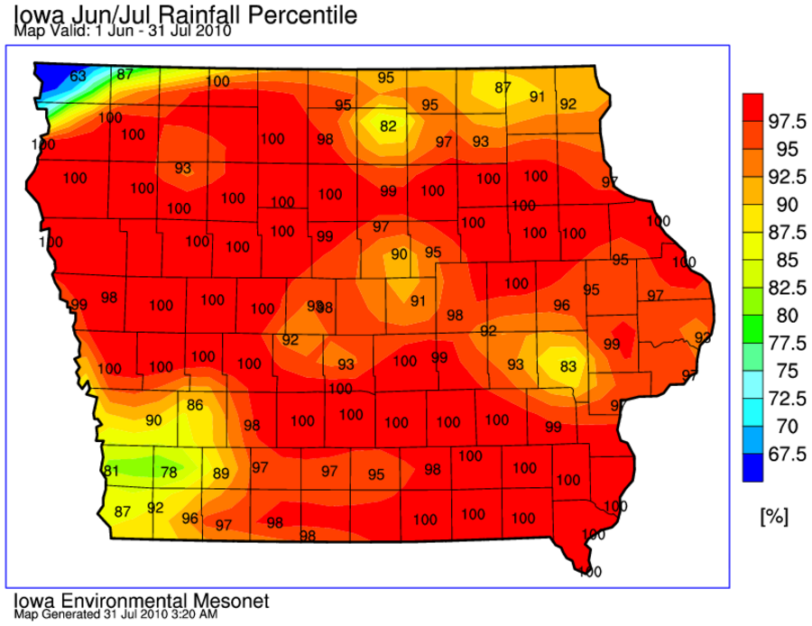
31 Jul 2010 03:25 AMThe featured map presents an IEM computed map of rainfall accumulation percentiles for June and July. A good portion of the state is analyzed at 100%, which would mean this year's total is the highest on record. August looks to get started a bit on the wet side, but lets hope we can have a below average month for precipitation!
Voting:
Good: 215
Bad: 56
Tags: jun10 jul10
Not all have seen the heavy rain
28 Jul 2010 06:10 AMJuly has been another very wet month for many locations in Iowa. The featured map displays estimated rainfall totals with some areas over twelve inches of rain for July. There are some areas in the state shown in the light green, which would be near average for the month. Showers are visiting the state this morning, but the heaviest rainfall should occur for locations outside of the state. Heavier rainfall is expected next week.
Voting:
Good: 38
Bad: 6
Tags: jul10


