Past IEM Features tagged: firstfreeze
Clouds and First Sub 29°F
17 Oct 2024 05:30 AMWith a strong surface high pressure system overhead, temperatures cooled nicely on Wednesday morning with most of the state experiencing the first freeze of the fall season. The Ames airport bottomed out to 24°F! The featured chart presents a time series of Ames airport cloud coverage reports for a +/- 24 hour period relative to the first fall sub 29°F reading. Each pixel represents an hourly report with tan values indicating missing data. It is very interesting and intuitive to see the lack of cloud cover near the occurrence of such a cold temperature. It is a testament to the importance of radiational cooling for such events as clouds act as the proverbial blanket to buoy near surface air temperatures during night time hours.
Voting:
Good: 9
Bad: 0
Tags: firstfreeze clouds
Accumulated Freeze Coverage
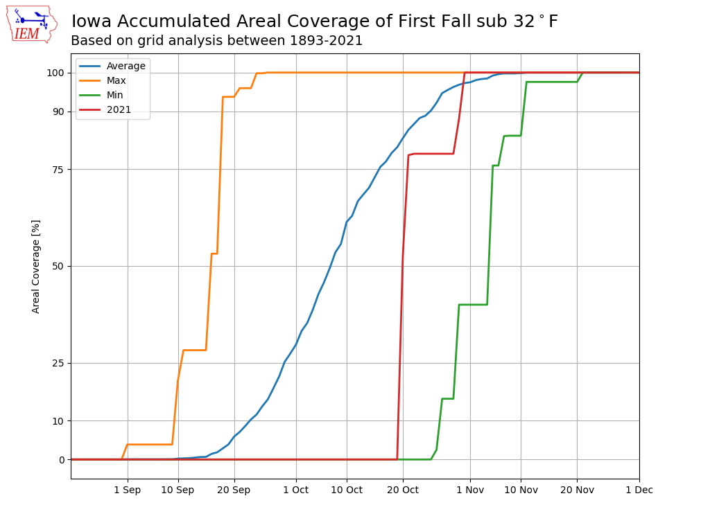
23 Sep 2022 05:27 AMWith about every accounting scheme now placing Iowa in the fall season, it is time to start worrying about when the first freeze will happen. Such temperatures are not far away from Iowa this Friday morning with sub freezing temperatures expected in Wisconsin. The featured chart presents an IEM analysis of the accumulated areal coverage over Iowa that has dipped below 32 degrees at least once by a given date of the fall season. This value is computed over a grid with the percentage of grid cells representing the coverage. The orange line represents the highest coverage by a given date and the green line the lowest coverage. The red line was last year's value and blue line is the simple climatology. So by the 23rd of September, at least some limited portions of the state have likely seen such cold temperatures. The 50 percent climatology value is about the second week of October, which nicely matches station climatology for a good chunk of the state.
Voting:
Good: 16
Bad: 0
Tags: firstfreeze
First Freeze Composite
29 Sep 2020 05:36 AMThe forecast for this coming weekend continues to push low temperatures well into the 30s and maybe a first freeze for some parts of the state. For weather forecasters, pattern recognition plays an important role. One of the main patterns forecasters look at is the 500 hPa (mb) height surface, whose height informs temperatures and orientation informs general wind circulations. The featured map presents a composite of this height field on mornings of the first fall freeze each year for Des Moines. The composite clearly shows ridging over the western US and troughing over the eastern. The flow orientation is thus out of the northwest, which is a source of cold air this time of year. Such a pattern is currently expected for the weekend, but having a sub freezing temperature is not a given and only in the realm of possibilities.
Voting:
Good: 16
Bad: 0
Tags: narr firstfreeze


