Past IEM Features tagged: coldfront
Front Passage
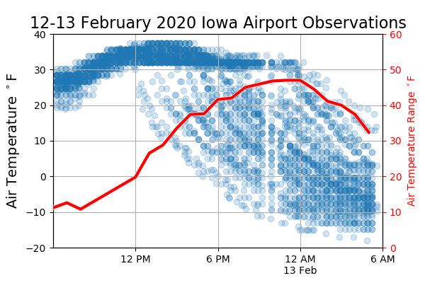
13 Feb 2020 05:35 AMBesides misery, strong arctic cold fronts bring plenty of interesting weather data to analyze. The featured chart presents available Iowa airport weather station temperature reports (blue dots) between 6 AM yesterday and this morning. A computed range over the state is shown by the red line. Temperatures were rather uniform over Iowa up until noon yesterday when the front entered northwestern Iowa. The plot nicely shows the streaks of falling temperatures as the cold front passes over individual stations. The front exited southeastern Iowa just before midnight making for a 12 hour trip to transverse the state.
Voting:
Good: 17
Bad: 31
Abstain: 5
Tags: coldfront
From 85 to snow
15 Apr 2014 05:37 AMAfter hitting a balmy 85 degrees on Saturday, it was only less than 36 hours later that the Des Moines Airport reported falling snow! The featured graphic shows events where the temperature went from 75+ degrees to then having a snow report within 36 hours. Our most recent event comes in a close third behind 1991 and 1975. There are only ten events on record for Des Moines going from 75+ to snowfall, so this type of dramatic swing is not that common.
Voting:
Good: 18
Bad: 9
Abstain: 2
Tags: snow coldfront
Front makes fools of us
01 Apr 2014 05:40 AMAnybody that based their Monday evening attire on the early afternoon temperature were made of fool of as a very strong cold front swept the state dropping the temperature by 40- 50 degrees. The featured chart presents the temperature time series on Monday for seven locations over Iowa. The temperature changes shown are remarkable. Tornadoes were even reported in southwestern Minnesota before the front passed and snow fell later in the evening. Highs today will make it back into the 40s and it appears we'll be stuck in that range for rest of the week.
Voting:
Good: 17
Bad: 9
Abstain: 6
Tags: coldfront
64 degree drop
30 Dec 2013 05:44 AMThe warm up this weekend was replaced by very cold air on Sunday. After setting a record high temperature on Saturday for Sioux City at 62 degrees, it was -2 less than 24 hours later! The featured chart presents the largest downward temperature swings for the site as recorded by the hourly observations. The only event with a larger change was back in 1982 as the temperature went from 83 down to 18 between 2 and 3 April. Our weather pattern looks to be active this week with numerous chances of snow.
Voting:
Good: 56
Bad: 15
Abstain: 11
Tags: coldfront temps
Big Temperature Crashes
10 Jan 2013 05:36 AMTemperatures are expected to warm nicely on Thursday and again on Friday before crashing into the weekend. The featured chart presents 24 hour temperature traces in between a day to day high temperature change of at least 30 degrees. The zero hour in this chart is after the peak temperature occurred for the first day. These events are almost always associated with cold front passage. The average fit line shows how quickly these events tend to occur with the temperature dropping 30 degrees within the first 8 hours. It remains to be seen if the high temperature on Saturday will be 30 degrees cooler than Friday.
Voting:
Good: 32
Bad: 8
Tags: coldfront
Deteoriate, improve, deteoriate, improve
13 Jan 2009 05:09 AMThe featured graph is a time series from the Spencer airport sensor showing air temps, wind speeds, and visibility distance. The morning hours saw a round of snowfall followed by improving conditions where temperatures rose to above freezing in many locations followed by a frontal passage with rapidly deteoriating conditions followed by a decrease in wind speeds with improving visibilities by bitterly cold temperatures. All of that makes for quite the weather day! The next winter storm will be here this evening already!
Voting:
Good: 23
Bad: 6
Tags: coldfront
80 degrees in 12 hours
16 Dec 2008 06:15 AMThe cold front passage on Sunday was one for the record books due to the drastic and rapid change in temperature. Today's featured plot is a time series from Ottumwa showing an amazing drop of 80 degrees in 12 hours. Note this is a drop from an air temperature of 60 to a wind chill value of -20. The actual air temperature drop was around 60 degrees in just 12 hours! Some analysis is currently being done to compare this drop to others in the past, stay tuned.
Voting:
Good: 33
Bad: 16
Tags: coldfront extreme

View larger image
Note the stair step nature of the temperature plot is due to the 1 degree precision of observations
Strong cold front
15 Dec 2008 06:14 AMA very intense cold front crossed the state on Sunday dropping our temperatures from the 40s and 50s almost immediately to values below freezing. The featured graph is a timeseries from the Corning SchoolNet site with observations shown every 6 seconds for a period of only 15 minutes! The rapid wind shift and initial temperature drop take place within a minute. Temperatures continued dropping for the rest of the day on Sunday and now are below zero for many locations in Iowa.
Voting:
Good: 36
Bad: 7
Tags: coldfront
What a difference 24 hours makes
30 Jan 2008 07:50 AMThe featured chart is of air temperatures from the Des Moines airport from Monday evening to Tuesday evening. You can see the precipitous 50 degree drop in temperature over just 24 hours. Today will be another very cold day with highs around 10 with more chances of snow beginning this evening and lasting into the weekend. Our brutal winter continues!
Voting:
Good: 23
Bad: 2
Tags: coldfront


