Past IEM Features tagged: 2020
Cold afternoon temps
20 Oct 2020 08:53 PMThe remarkable weather events of 2020 have rolled on this week with a third day of snowfall over some portion of the state. Temperatures on Monday with the snowfall during the day were very cold for this time of year. The featured chart presents the hourly reports from the Des Moines Airport along with the last date having as cold a temperature for that hour based on unofficial archives maintained by the IEM back to 1936. A number of hours during the afternoon hours into the early evening were the coldest on record for fall season dates prior to 20 October! Other locations like Cedar Rapids and Dubuque were similarly as cold. Temperatures are now on the rebound with 70s expected for Thursday along with a chance of severe weather, because why not!
Voting:
Good: 16
Bad: 0
Tags: 2020
2020 Humidity
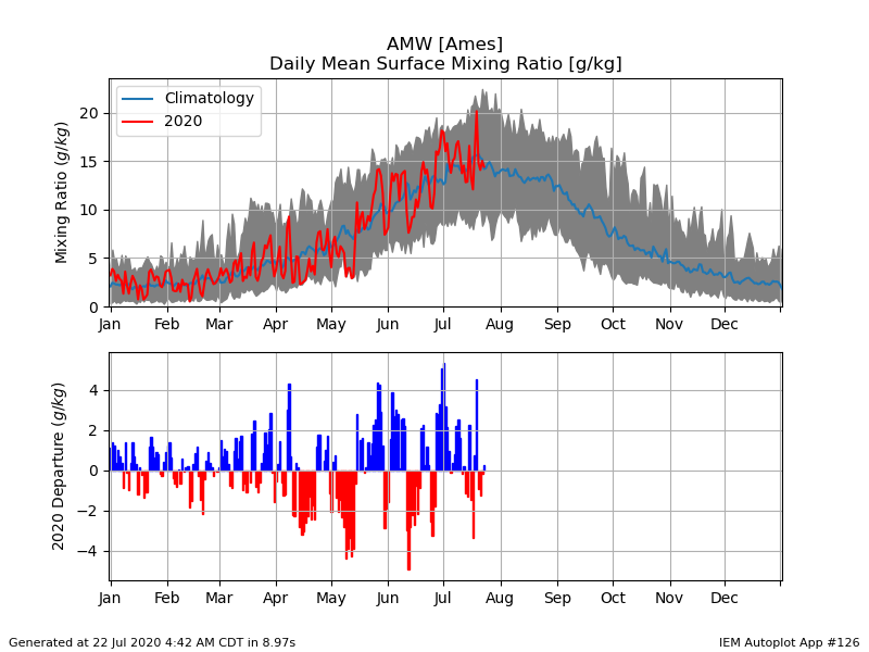
22 Jul 2020 04:54 AMThe amount of water vapor the air can hold is a function of its temperature. So it makes sense that the peak in humidity happens about the same time as temperature as shown by the featured chart. The chart presents humidity climatology for Ames expressed in terms of mixing ratio. The envelope of daily data is shown by the gray shaded area, the simple average by the blue line, and this year's values by the red line. The bottom panel shows the daily departure from average. It is interesting to note that even our lowest humidity values on record during the summer are still about double that of the highest winter values. The forecast shows a rise in humidity by the end of the week with a muggy and hot weekend in store.
Voting:
Good: 10
Bad: 0
Tags: humidity 2020
Carroll Precipitation
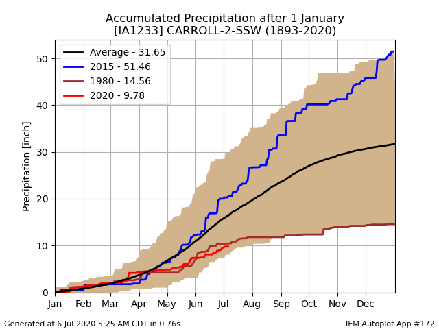
06 Jul 2020 05:33 AMPrecipitation continues to be elusive for parts of the state this summer. The driest area has been west central Iowa with the featured chart highlighting the year to date precipitation total for Carroll, Iowa. This year's accumulated total is plotted along with the yearly max, min and envelope of period of record data. The 2020 total is currently below the driest year of 1980 for the year to date period. About the only thing that is saving the driest areas of the state is the wet end to 2019 and mostly saturated soil moisture profile to start off the growing season. Conditions are expected to continue to deteriorate with hot and dry conditions prevailing for the near term future.
Voting:
Good: 13
Bad: 0
Tags: 2020
More Reds this Year
02 Apr 2020 05:39 AMThe featured chart is a simple comparison showing the percentage of NWS "CLI"mate reporting sites that reported an above or below average daily high temperature over the continental US since the first of this year. This number is biased to the eastern side of the US as no attempt was made to weight the numbers by area. That issue aside, the chart shows that much of this year has been spent with over half of these stations reporting an above average temperature. This is thanks to a persistent weather pattern that has kept cold air at bay for the east coast.
Voting:
Good: 10
Bad: 0
Tags: 2020


