IEM Daily Feature
Tuesday, 11 March 2014
Tuesday, 11 March 2014
Obvious Relationship
Posted: 11 Mar 2014 05:37 AM
After a wonderful Sunday, Monday was able to top it with temperatures soaring to levels not
seen since last year. Sioux City was able to tie a record high temperature of 74 degrees.
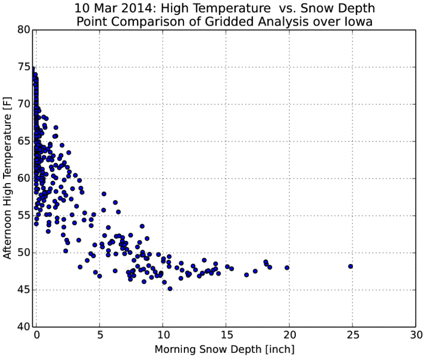
Not all of the state was able to get that warm and the sole reason was the deep snowpack
that still exists over much of northeastern Iowa. The featured chart shows the obvious
relationship between morning snow cover and the afternoon high temperature over Iowa for
Monday. A forecasting rule of thumb states that the high temperature can not exceed 43
degrees when there is at least four inches of snow depth present in the morning, but this
rule does not hold when significant warm air advection is happening. Warm air advection is
the process of moving warmer air into areas with colder air. This warm air from the south
helps to push temperatures even warmer.
Voting:
Good = 24
Bad = 11
Abstain = 6
Tags: snowcover
Voting:
Good = 24
Bad = 11
Abstain = 6
Tags: snowcover

