National Weather Service Raw Text Product
Displaying AFOS PIL: RTPMKX Product Timestamp: 2025-01-20 12:23 UTC
Previous in Time Latest Product Next in Time
View All KMKX Products for 20 Jan 2025 View All RTP Products for 20 Jan 2025 View As Image Download As Text
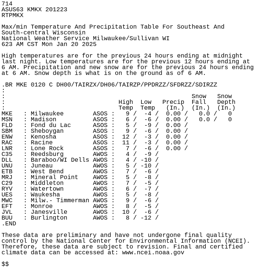
714
ASUS63 KMKX 201223
RTPMKX

Max/min Temperature And Precipitation Table For Southeast And
South-central Wisconsin
National Weather Service Milwaukee/Sullivan WI
623 AM CST Mon Jan 20 2025

High temperatures are for the previous 24 hours ending at midnight
last night. Low temperatures are for the previous 12 hours ending at
6 AM. Precipitation and new snow are for the previous 24 hours ending
at 6 AM. Snow depth is what is on the ground as of 6 AM.

.BR MKE 0120 C DH00/TAIRZX/DH06/TAIRZP/PPDRZZ/SFDRZZ/SDIRZZ
:
:                                                   Snow   Snow
:                               High  Low   Precip  Fall   Depth
:                               Temp  Temp   (In.)  (In.)  (In.)
MKE   : Milwaukee        ASOS :   9 /  -4 /  0.00 /   0.0 /   0
MSN   : Madison          ASOS :   6 /  -6 /  0.00 /   0.0 /   0
FLD   : Fond du Lac      ASOS :   5 /  -9 /  0.00 /
SBM   : Sheboygan        ASOS :   9 /  -6 /  0.00 /
ENW   : Kenosha          ASOS :  12 /  -3 /  0.00 /
RAC   : Racine           ASOS :  11 /  -3 /  0.00 /
LNR   : Lone Rock        ASOS :   7 /  -6 /  0.00 /
C35   : Reedsburg        AWOS :   4 /  -9 /
DLL   : Baraboo/WI Dells AWOS :   4 / -10 /
UNU   : Juneau           AWOS :   5 / -10 /
ETB   : West Bend        AWOS :   7 /  -6 /
MRJ   : Mineral Point    AWOS :   5 /  -8 /
C29   : Middleton        AWOS :   7 /  -5 /
RYV   : Watertown        AWOS :   6 /  -7 /
UES   : Waukesha         AWOS :   5 /  -8 /
MWC   : Milw.- Timmerman AWOS :   9 /  -6 /
EFT   : Monroe           AWOS :   8 /  -5 /
JVL   : Janesville       AWOS :  10 /  -6 /
BUU   : Burlington       AWOS :   8 / -12 /
.END

These data are preliminary and have not undergone final quality
control by the National Center for Environmental Information (NCEI).
Therefore, these data are subject to revision. Final and certified
climate data can be accessed at: www.ncei.noaa.gov

$$