National Weather Service Raw Text Product
Displaying AFOS PIL: RTPARX Product Timestamp: 2025-01-22 00:24 UTC
Previous in Time Latest Product Next in Time
View All KARX Products for 22 Jan 2025 View All RTP Products for 22 Jan 2025 View As Image Download As Text
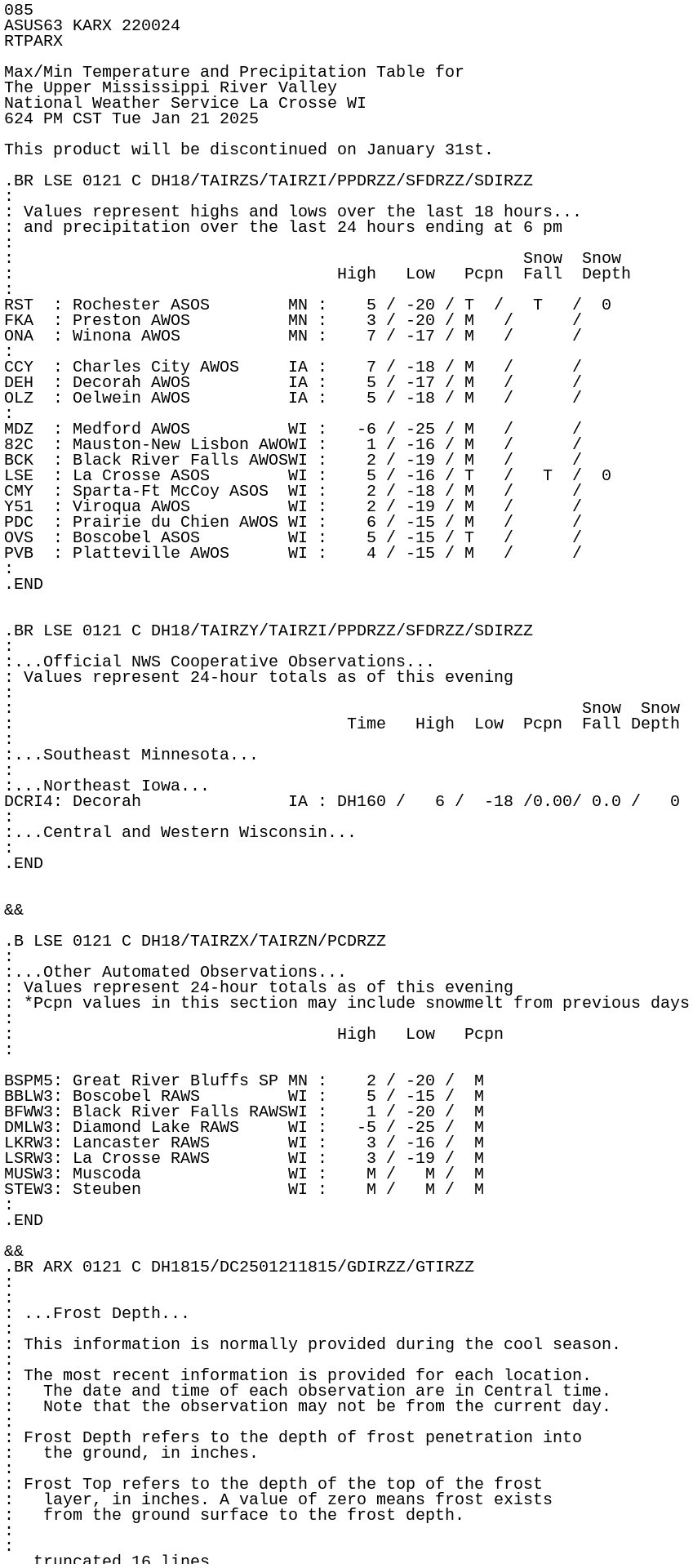
085
ASUS63 KARX 220024
RTPARX

Max/Min Temperature and Precipitation Table for
The Upper Mississippi River Valley
National Weather Service La Crosse WI
624 PM CST Tue Jan 21 2025

This product will be discontinued on January 31st.

.BR LSE 0121 C DH18/TAIRZS/TAIRZI/PPDRZZ/SFDRZZ/SDIRZZ
:
: Values represent highs and lows over the last 18 hours...
: and precipitation over the last 24 hours ending at 6 pm
:
:                                                    Snow  Snow
:                                 High   Low   Pcpn  Fall  Depth
:
RST  : Rochester ASOS        MN :    5 / -20 / T  /   T   /  0
FKA  : Preston AWOS          MN :    3 / -20 / M   /      /
ONA  : Winona AWOS           MN :    7 / -17 / M   /      /
:
CCY  : Charles City AWOS     IA :    7 / -18 / M   /      /
DEH  : Decorah AWOS          IA :    5 / -17 / M   /      /
OLZ  : Oelwein AWOS          IA :    5 / -18 / M   /      /
:
MDZ  : Medford AWOS          WI :   -6 / -25 / M   /      /
82C  : Mauston-New Lisbon AWOWI :    1 / -16 / M   /      /
BCK  : Black River Falls AWOSWI :    2 / -19 / M   /      /
LSE  : La Crosse ASOS        WI :    5 / -16 / T   /   T  /  0
CMY  : Sparta-Ft McCoy ASOS  WI :    2 / -18 / M   /      /
Y51  : Viroqua AWOS          WI :    2 / -19 / M   /      /
PDC  : Prairie du Chien AWOS WI :    6 / -15 / M   /      /
OVS  : Boscobel ASOS         WI :    5 / -15 / T   /      /
PVB  : Platteville AWOS      WI :    4 / -15 / M   /      /
:
.END


.BR LSE 0121 C DH18/TAIRZY/TAIRZI/PPDRZZ/SFDRZZ/SDIRZZ
:
:...Official NWS Cooperative Observations...
: Values represent 24-hour totals as of this evening
:
:                                                          Snow  Snow
:                                  Time   High  Low  Pcpn  Fall Depth
:
:...Southeast Minnesota...
:
:...Northeast Iowa...
DCRI4: Decorah               IA : DH160 /   6 /  -18 /0.00/ 0.0 /   0
:
:...Central and Western Wisconsin...
:
.END


&&

.B LSE 0121 C DH18/TAIRZX/TAIRZN/PCDRZZ
:
:...Other Automated Observations...
: Values represent 24-hour totals as of this evening
: *Pcpn values in this section may include snowmelt from previous days
:
:                                 High   Low   Pcpn
:

BSPM5: Great River Bluffs SP MN :    2 / -20 /  M
BBLW3: Boscobel RAWS         WI :    5 / -15 /  M
BFWW3: Black River Falls RAWSWI :    1 / -20 /  M
DMLW3: Diamond Lake RAWS     WI :   -5 / -25 /  M
LKRW3: Lancaster RAWS        WI :    3 / -16 /  M
LSRW3: La Crosse RAWS        WI :    3 / -19 /  M
MUSW3: Muscoda               WI :    M /   M /  M
STEW3: Steuben               WI :    M /   M /  M
:
.END

&&
.BR ARX 0121 C DH1815/DC2501211815/GDIRZZ/GTIRZZ
:
:
: ...Frost Depth...
:
: This information is normally provided during the cool season.
:
: The most recent information is provided for each location.
:   The date and time of each observation are in Central time.
:   Note that the observation may not be from the current day.
:
: Frost Depth refers to the depth of frost penetration into
:   the ground, in inches.
:
: Frost Top refers to the depth of the top of the frost
:   layer, in inches. A value of zero means frost exists
:   from the ground surface to the frost depth.
:
:
:                           Date/Time  Frost   Frost
:       Location              DDHHMM   Depth    Top
:
ARX  : NWS La Crosse WI   : DD200700/   11/    M
:
.END

These data are preliminary and have not undergone final quality
control by the National Centers for Environmental Information (NCEI).
Therefore, these data are subject to revision. Final and certified
climate data can be accessed at: www.ncei.noaa.gov

$$

Boyne