National Weather Service Raw Text Product
Displaying AFOS PIL: RTPABR Product Timestamp: 2025-01-28 17:20 UTC
Previous in Time Latest Product Next in Time
View All KABR Products for 28 Jan 2025 View All RTP Products for 28 Jan 2025 View As Image Download As Text
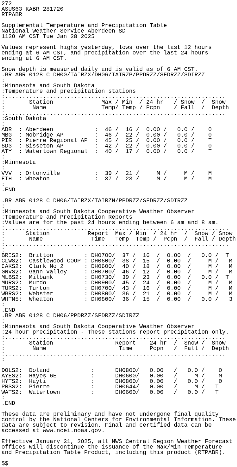
272
ASUS63 KABR 281720
RTPABR

Supplemental Temperature and Precipitation Table
National Weather Service Aberdeen SD
1120 AM CST Tue Jan 28 2025

Values represent highs yesterday, lows over the last 12 hours
ending at 6 AM CST, and precipitation over the last 24 hours
ending at 6 AM CST.

Snow depth is measured daily and is valid as of 6 AM CST.
.BR ABR 0128 C DH00/TAIRZX/DH06/TAIRZP/PPDRZZ/SFDRZZ/SDIRZZ
:
:Minnesota and South Dakota
:Temperature and precipitation stations
:................................................................
:       Station              Max / Min  / 24 hr   / Snow  /  Snow
:        Name                Temp/ Temp / Pcpn    / Fall  /  Depth
:................................................................
:South Dakota
:
ABR  : Aberdeen            :  46 /  16 /  0.00 /   0.0 /    0
MBG  : Mobridge AP         :  46 /  22 /  0.00 /   0.0 /    0
PIR  : Pierre Regional AP  :  45 /  25 /  0.00 /   0.0 /    T
8D3  : Sisseton AP         :  42 /  22 /  0.00 /   0.0 /    0
ATY  : Watertown Regional  :  40 /  17 /  0.00 /   0.0 /    T
:
:Minnesota
:
VVV  : Ortonville          :  39 /  21 /     M /     M /    M
ETH  : Wheaton             :  37 /  23 /     M /     M /    M
:
.END

.BR ABR 0128 C DH06/TAIRZX/TAIRZN/PPDRZZ/SFDRZZ/SDIRZZ
:
:Minnesota and South Dakota Cooperative Weather Observer
:Temperature and Precipitation Reports
:Values are for the past 24 hours ending between 6 am and 8 am.
:.................................................................
:      Station           Report  Max / Min  / 24 hr  /  Snow / Snow
:       Name              Time   Temp  Temp /  Pcpn  /  Fall / Depth
:.................................................................
:
BRIS2:  Britton         : DH0700/  37 /  16  /  0.00  /   0.0 /  T
CLWS2:  Castlewood COOP : DH0600/  38 /  15  /  0.00  /     M /   M
CAKS2:  Clark No 2      : DH0600/  40 /  18  /  0.00  /     M /   M
GNVS2:  Gann Valley     : DH0700/  46 /  12  /  0.00  /     M /   M
MLBS2:  Milbank         : DH0730/  39 /  23  /  0.00  /   0.0 /  T
MURS2:  Murdo           : DH0900/  45 /  24  /  0.00  /     M /   M
TURS2:  Turton          : DH0700/  43 /  16  /  0.00  /     M /   M
WBRS2:  Webster         : DH0800/  36 /  21  /  0.00  /     M /   M
WHTM5:  Wheaton         : DH0800/  36 /  15  /  0.00  /   0.0 /   3
:
.END
.BR ABR 0128 C DH06/PPDRZZ/SFDRZZ/SDIRZZ
:
:Minnesota and South Dakota Cooperative Weather Observer
:24 hour precipitation - These stations report precipitation only.
:................................................................
:       Station                  Report    24 hr  /  Snow /  Snow
:        Name                     Time     Pcpn   /  Fall /  Depth
:................................................................
:

DOLS2:  Doland            :      DH0800/   0.00   /   0.0 /    0
AYES2:  Hayes 6E          :      DH0600/   0.00   /     M /    M
HYTS2:  Hayti             :      DH0800/   0.00   /   0.0 /    0
PRSS2:  Pierre            :      DH0644/   0.00   /     M /   T
WATS2:  Watertown         :      DH0600/   0.00   /   0.0 /   T
:
.END

These data are preliminary and have not undergone final quality
control by the National Centers for Environmental Information. These
data are subject to revision. Final and certified data can be
accessed at www.ncei.noaa.gov.

Effective January 31, 2025, all NWS Central Region Weather Forecast
offices will discontinue the issuance of the Max/Min Temperature
and Precipitation Table Product, including this product (RTPABR).

$$