IEM Daily Feature
Tuesday, 03 January 2023
Tuesday, 03 January 2023
Freezing Rain Soundings
Posted: 03 Jan 2023 05:30 AM
Yesterday's featured map showed that the Ice Storm Warning is a rather rare headline issued by the
National Weather Service. The main reason why it is rare is that a number of factors need to align and
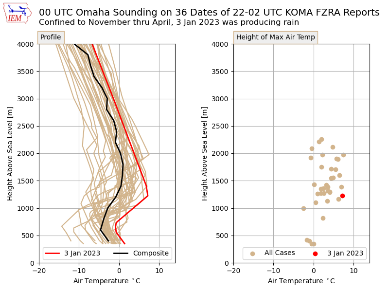
the margin between an event turning to all snow or to all rain is very thin. The featured chart presents a
quick analysis of Omaha soundings coincident with reports of freezing rain from the airport weather
station. There are caveats galore with a plot like this, but some general characteristics are informative.
While the Omaha airport was reporting rain at the time, the profile for Monday evening (3 January in
UTC) is included as well for a comparison. The left panel shows the air temperature profiles and right
panel shows the height of the maximum temperature. In general, the plot shows the classic warm
"nose" aloft that allows falling precipitation to melt to rain and then fall into a shallow layer of air near
the surface that is just below freezing. The red line shows the profile last night and it can be seen to be
too warm to support freezing the precipitation.
Voting:
Good = 11
Bad = 0
Tags: sounding freezingrain
Voting:
Good = 11
Bad = 0
Tags: sounding freezingrain

