IEM Daily Feature
Thursday, 31 December 2020
Thursday, 31 December 2020
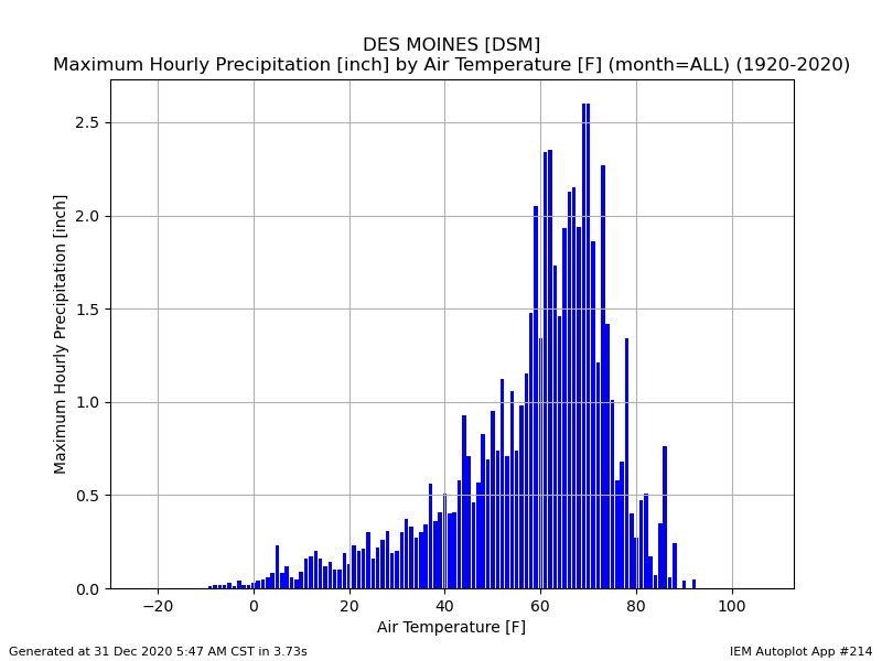
Max Hourly Precipitation by Temperature
Posted: 31 Dec 2020 06:00 AM
The most recent winter storm featured some intense snowfall rates. The Des Moines Airport sensor
reported 0.21" at 3 PM with an air temperature of just 23 degrees. This is the highest observed
precipitation rate at 23 degrees for the site according to the IEM's unofficial records. The featured
chart presents the max hourly precipitation coincident with a given temperature reported at the time
of the hourly precipitation total. These types of charts often quickly show bad data points, but the
plot looks clean for this site. The major caveat is how the site has attempted to measure and report
below freezing liquid precipitation over the years. The sensor package used by some cold region
ASOS sites has dramatically improved over the years. All of that aside, the chart is very illustrative of
some basic meteorology involving the Clausius-Clapeyron equation. The equation states that
warmer air can hold more water, so it makes sense that more precipitation can fall as the temperature
increases. But why do the rates start to drop after about 70 degrees? Intense rainfall implies near
100% relative humidity (temperature equals dew point), so the high end of this plot is limited by what
we can possibility experience for dew point temperatures. This plot is looking backwards in time, so
the intense hourly precipitation has likely helped to cool the temperature. Think of the hot and muggy
conditions before a storm being cooled off as it rains.
Voting:
Good = 12
Bad = 0
Voting:
Good = 12
Bad = 0

