IEM Daily Feature
Thursday, 11 May 2017
Thursday, 11 May 2017
Watches
Posted: 11 May 2017 12:02 AM
NWS Des Moines issued two watches yesterday, a Severe Thunderstorm Watch and a
Flash Flood Watch. The eventual storms yesterday did yield a few Severe Thunderstorm
Warnings over the watch area and even a few tornadoes further east within Davenport
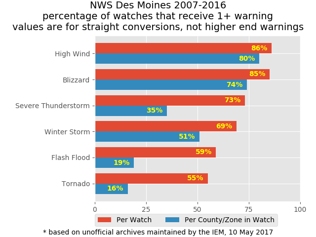
NWS's area, but no Flash Flood Warnings. The featured chart looks at some IEM
computed metrics on the conversion of watches into warnings. The red bars represent the
overall frequency of converting an individual watch event into a warning (meaning getting at
least one warning anywhere within the watch). The blue bars represent the individual
county/zone conversion of a watch into a warning. For example, there is a 59% chance of
getting at least one warning within the Flash Flood Watch yesterday and 19% frequency of
an individual county within the watch getting one warning. The moral of this story is that not
all watches are created equal. The actual size of the event the watch is for creates large
differences in the frequencies. One item to note is that this plot is for a straight conversion
and does not consider the situation of the eventual warning being of a different type. For
example, some Winter Storm Watches become Blizzard Warnings.
Voting:
Good = 5
Bad = 0
Tags: nws watch
Voting:
Good = 5
Bad = 0
Tags: nws watch

