IEM Daily Feature
Thursday, 18 December 2008
Thursday, 18 December 2008
Ice Storm Coming
Posted: 18 Dec 2008 06:04 AM
Today's feature is contributed by BUFKIT Warehouse proprietor Chris Karstens:
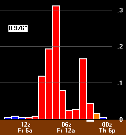
The featured plot shows a BUFKIT time series (right to left) of precipitation amount and type from the Wednesday night run of the NWS NAM Model for Ottumwa Iowa. This plot would indicate an inch of ice accumulation between Thursday afternoon and Friday morning. That amount of ice would cause considerable power outages and tree damage. Futher north in Iowa, more snow is expected with accumulations upwards of 8 inches.
Voting:
Good = 46
Bad = 15
Tags: bufkit

