The Iowa Environmental Mesonet (IEM) collects environmental data from cooperating members with observing networks. The data are stored and made available on this website.

NWS Des Moines Flood Warnings
Posted: 03 May 2024 05:30 AM, Views: 136
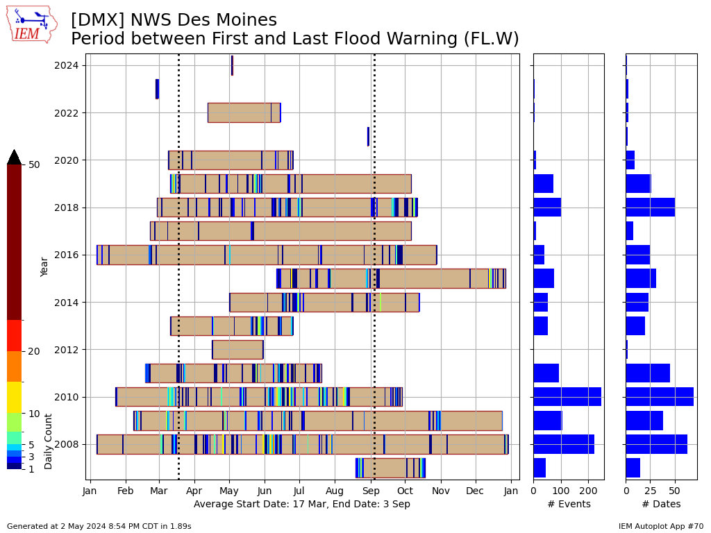
The National Weather Service issues Flood Warnings for monitored points along rivers when the forecast stage (river height) is expected to cause flooding. NWS Des Moines issued their first such warning of the year yesterday for the East Fork of the Des Moines River at Algona. This was the office's first such warning since February of last year! The featured chart presents the period each year between the first and last issuance along with the number of issuances per day. Flood Warnings tend to last many days, so unfortunately this visualization does not represent that aspect of these warnings. Anyway, the chart is still informative when one compares this to years dominated by drought, namely 2012 and a number of recent years. The very wet years of 2008 and 2010 certainly stand out on this chart as well. For recently drought stricken Iowa, a bit of flooding is a good sign that our hydrological situation is improving. Of course, it would be nice if things do not get out of hand over the months ahead.
Previous Years' Features
16 April NWS Data Outage [resolved]
Posted: 16 Apr 8:53 AM
15 April NWS Website Outage [resolved]
Posted: 15 Apr 9:54 PM
15 April GOES Outage [resolved]
Posted: 15 Apr 10:52 AM
3 April NWS Data Outage
Posted: 3 Apr 1:08 PM
2 April NWS Data Outage
Posted: 2 Apr 8:40 AM
Sign up for the Daily Bulletin
Soil Temperatures

Data from the Iowa State Soil Moisture Network is found on this website and daily soil temperature averages are used to produce the highlighted analysis.

Current Data
The IEM combines data from participating networks into products like maps shown above and web applications to analyze the data.
Partners: