IEM Daily Feature
Wednesday, 21 August 2013
Wednesday, 21 August 2013
Dewpoint and morning low
Posted: 21 Aug 2013 05:48 AM
Warmer and muggier weather is back in Iowa with dewpoint temperatures
in the upper 60s and lower 70s. The increase in moisture means we are
done with the overnight lows in the 50s as the dewpoint puts a floor in
on how low the temperature can drop. The reason being that once the
air reaches saturation, fog will form and temperatures will be
stabilized as long wave radiation is absorbed and heat is released as
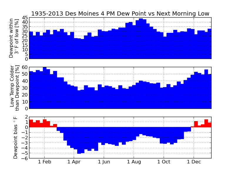
water vapor condenses. The featured chart looks at the relationship
between the 4 PM dewpoint temperature and then the morning low
temperature for the next day. The top chart shows the percentage of
days the low temperature is within 3 degrees of the 4 PM dewpoint. The
middle chart shows the frequency of the low temperature being colder
than the 4 PM dewpoint. The bottom chart shows the overall bias of the
dewpoint and the next day low temperature. The reasons that this
relationship does not always work include: winds can create mixing that
prevents temperatures from cooling to the dewpoint, clouds prevent heat
from escaping, and/or advection processes can transport more humid or
drier air masses changing the dew point overnight.
Same plot for Ames and Cedar Rapids
Voting:
Good = 104
Bad = 10
Tags: dewpoint forecasting

