Past IEM Features tagged: wpc

Lowest in the Contiguous US
28 Dec 2022 12:01 AMThe Weather Prediction Center (WPC) issues a daily national high and low temperature product that contains their analyzed coldest and warmest temperature over the contiguous US (meaning sans Alaska, Hawaii, island territories). Three Iowa sites made this listing yesterday for the coldest temperature. The featured table presents an IEM analysis of when Iowa sites made this national listing. All of the entries are for coldest temperature over the archive period as no max temperature events were found. The reason Iowa was the coldest had to do with the combination of a fresh/fluffy snowfall, a surface high pressure system in the vicinity, and a warming western US with major pattern shift underway.
Voting:
Good: 5
Bad: 0
Tags: wpc
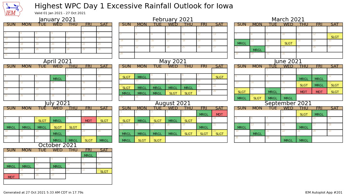
Excessive Rainfall Outlooks
27 Oct 2021 05:35 AMMuch like how the Storm Prediction Center issues convective outlooks with categorical threat levels, the Weather Prediction Center issues excessive rainfall outlooks. These outlooks highlight risk levels associated with flash flooding from intense rainfall rates. The IEM attempts to process and archive these with the featured graphic presenting a calendar of maximum daily threat level over some portion of Iowa. A number of moderate risks can be seen with the most recent occurring this past Sunday.
Voting:
Good: 13
Bad: 2
Abstain: 1
Tags: ero wpc
Chance of 8+ Inches
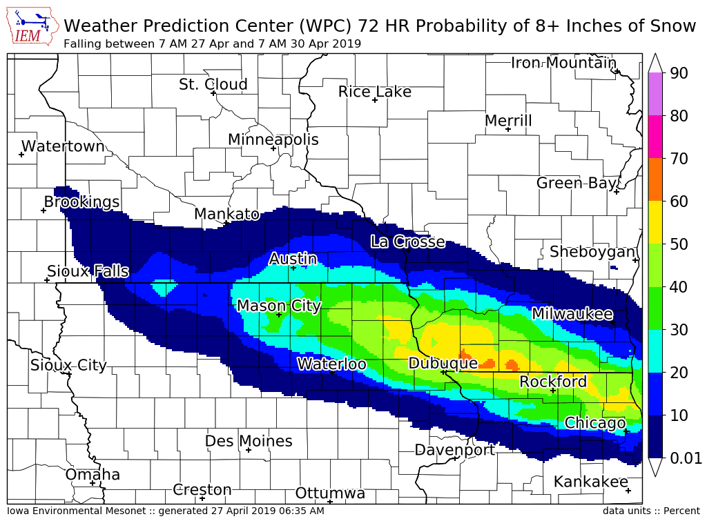
27 Apr 2019 06:42 AMThe featured map is of forecast probability that at least eight inches of snow falls over the next 72 hours from the Weather Prediction Center. This is an amazing map considering that the calendar says April 27th! Big snowfalls this time of year fall as the concrete kind with major threats to damaging trees and making impossible travel conditions. To accumulate this much snow, it needs to fall quickly to mitigate the impacts of warm soil temperatures and any filtered sunshine working to melt it.
Voting:
Good: 12
Bad: 0
Tags: wpc
Snow Stays Northwest
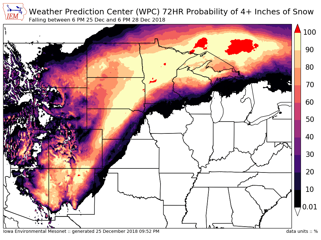
26 Dec 2018 05:52 AMThe featured map depicts forecast probabilities of accumulating at least four inches of snowfall over the coming 3 days ending Friday evening from the Weather Prediction Center. The probabilities shown over far northern Iowa are generally below 30% and the highest chances are just to our north and west. Iowa should see a fair amount of rain out of the coming storm system however.
Voting:
Good: 10
Bad: 0
Tags: wpc

Next Seven Days
03 Aug 2018 05:34 AMThe weekly update to the US Drought Monitor was released on Thursday and showed a continued degradation over southern Iowa. For agricultural crops that are still holding on for some needed rain this growing season, time is running out. The featured map depicts the combination of the most recent Drought Monitor and the seven day forecasted precipitation amount from the Weather Prediction Center. The heaviest totals are inconveniently predicted to the north of the driest area over the state. A silver lining here is that the map is not full of zero precipitation predictions, but hotter temperatures are expected which will increase the stress on already stressed crops in the area.
Voting:
Good: 16
Bad: 0
Tags: wpc usdm
Next Five Days
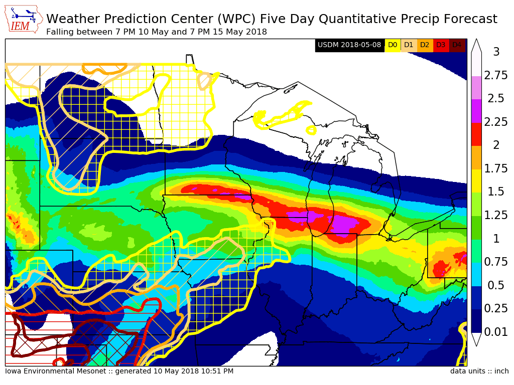
11 May 2018 05:33 AMThe featured map combines the five day precipitation forecast from the Weather Prediction Center and the most recent US Drought Monitor analysis. The heaviest totals on this map are unfortunately over areas that don't really need the rain currently and rather need dry weather to make spring planting progress. The driest areas over southern Iowa may get some needed rain, but the even drier areas to our southwest look to mostly miss out on the stormy pattern over the next few days.
Voting:
Good: 11
Bad: 0
Tags: wpc
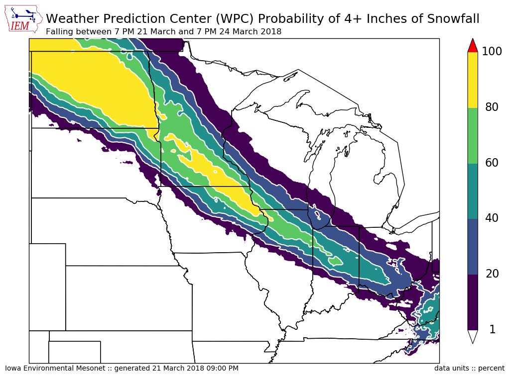
Chance of 4+ Inches
22 Mar 2018 05:35 AMThe featured map is forecast probabilities of at least four inches of snow falling over the next 72 hours from the Weather Prediction Center (a part of NWS/NOAA). This will be from a big storm system arriving on Friday and set to bring a lot of moisture into the state. The question remains as to where the rain to snow transition will be and the featured map depicts a forecast location of north and northeastern Iowa. Other parts of the state are expected to receive significant amounts of rain.
Voting:
Good: 10
Bad: 0
Tags: wpc
Upcoming Wet Three Days
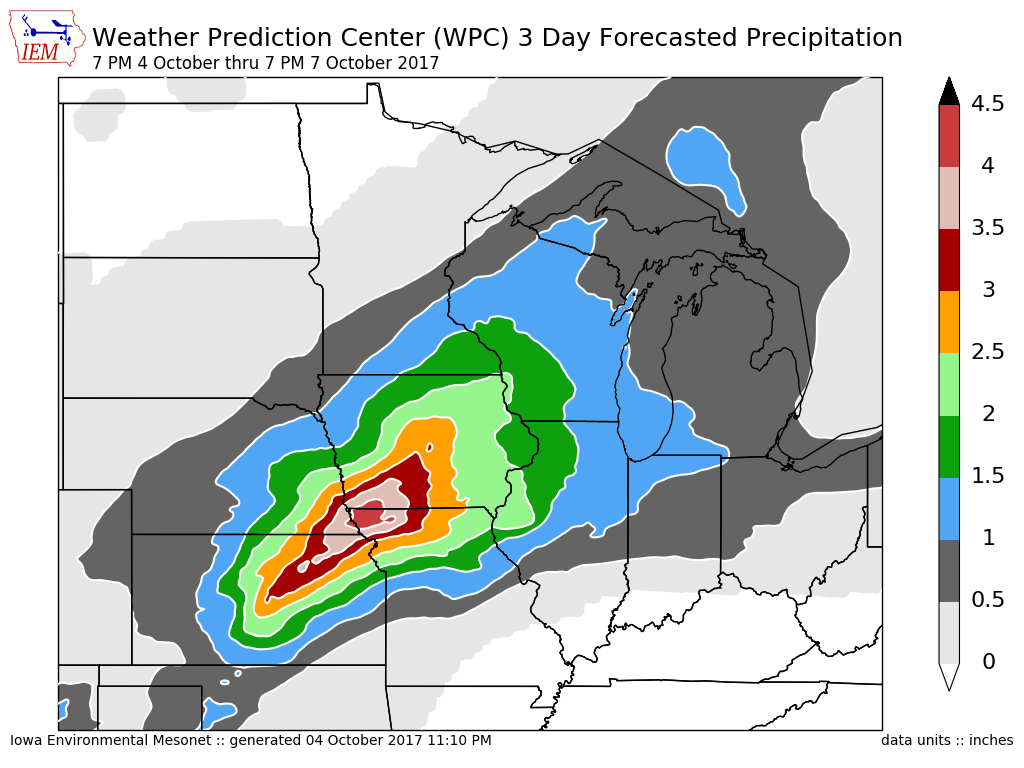
05 Oct 2017 05:33 AMThe featured map displays Weather Prediction Center forecast 72 hour precipitation totals between 7 PM last night and 7 PM Saturday evening. Most of southwestern Iowa is shown in the 3 to 4.5 inch range with most of Iowa even above two inches. This may be the most widespread and largest rainfall event in the state so far this year. Of course, a bit of pessimism rules after recent rain events have managed to not fully cover the drought stricken areas over southern Iowa. This event will likely set back the fall corn and soybean harvest progress as it would take a bit of time for fields to dry out from this much rain.
Voting:
Good: 12
Bad: 0
Tags: wpc
Wet end to June
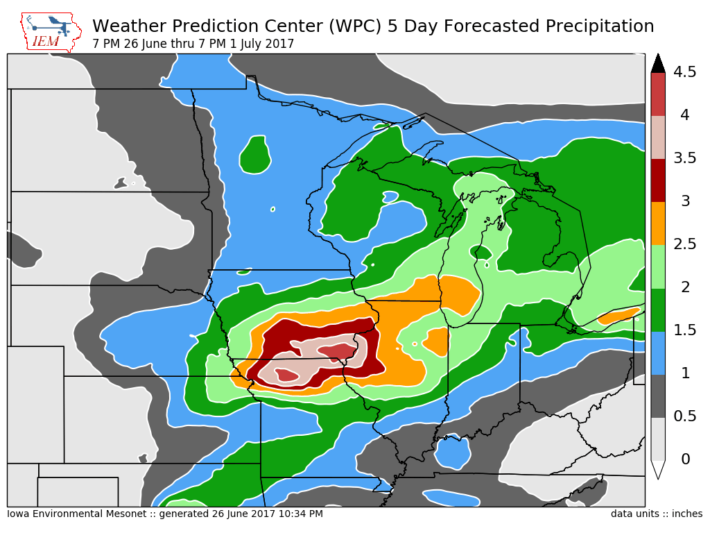
27 Jun 2017 05:19 AMThe featured map presents a precipitation forecast from the Weather Prediction Center for the next five days. This forecast is optimistic for a heavy rainfall event to occur over southern Iowa with amounts over four inches depicted over portions of the area. This particular part of the state could certainly use the rain, but the dry portions of northwestern Iowa may miss out. As with storms this time of year, the day to day details can be tricky as small scale details of one round of storms will impact the subsequent round. The storms will get going Tuesday night as increased humidity levels return to the state.
Voting:
Good: 11
Bad: 0
Tags: wpc
Wet Weather Returns
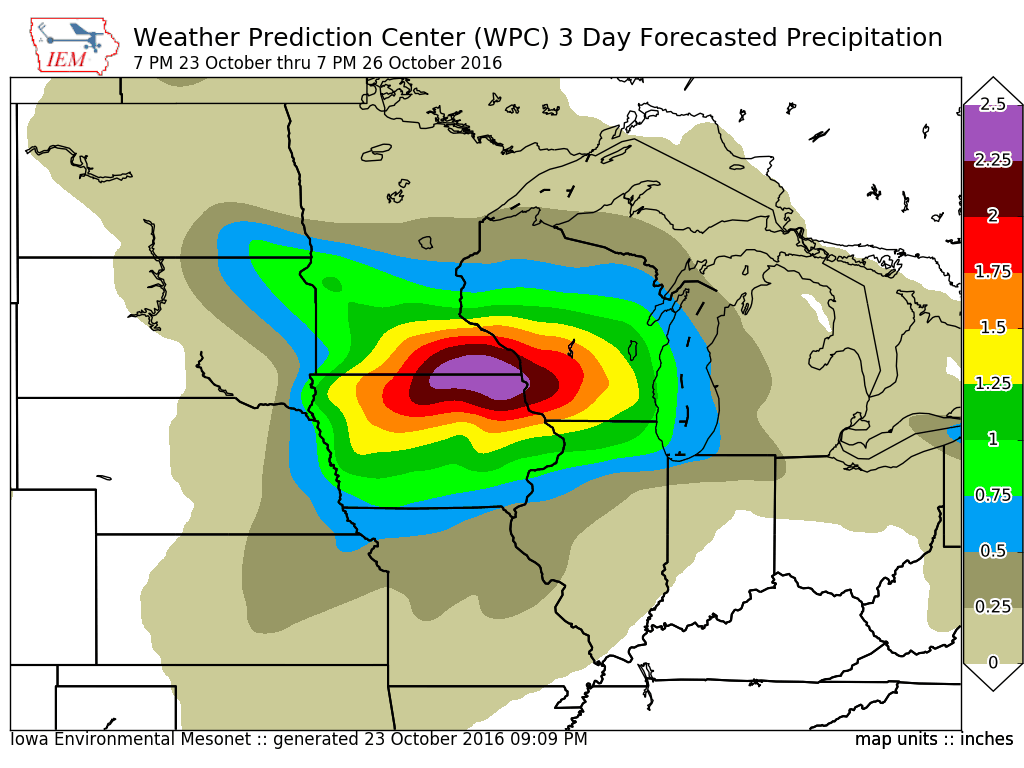
24 Oct 2016 05:35 AMAfter an extremely wet September, Iowa has mostly avoided any followup significant rains in October. The featured map is forecasted precipitation from the Weather Prediction Center showing a bullseye over two inches depicted over northeastern Iowa up until Wednesday evening. This is the same area that experienced big rains in September. Thankfully, it has been a number of weeks since the most recent big rainfall, so the impacts of this should be limited. It certainly will not help the crop harvest that was already delayed in the area.
Voting:
Good: 10
Bad: 0
Tags: wpc

Heavy rainfall to our south
30 Oct 2013 05:45 AMThe big story this week is the amount of rainfall expected to fall just to our south. The featured map is forecasted five day precipitation from the Weather Prediction Center. Totals for extreme southeastern Iowa are shown approaching two inches with amounts trailing as you go northwest. The rain is expected to get started today and last into Thursday. Temperatures will be warm enough not to worry about snow from this storm system.
Voting:
Good: 27
Bad: 4
Abstain: 5
Tags: wpc

Dry Work Week
14 May 2012 05:50 AMThe featured map is forecast precipitation for this week until Friday evening by the Hydrometeorological Prediction Center. Only very small amounts of rain are shown over northeastern Iowa with the rest of the state remaining dry. A week of dry weather is exactly what most farmers in the state need to help complete the spring field work.
Voting:
Good: 31
Bad: 2
Tags: wpc
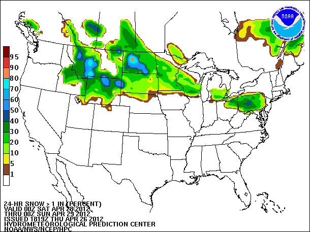
Late April Snow Coming?
27 Apr 2012 05:52 AMThe featured map is forecasted probabilities for an inch or more of snow on Saturday from the Hydrometeorological Prediction Center. While most of Iowa looks to avoid the best chances of seeing snow, the temperatures will certainly be plenty cold for this time of year with high temperatures this weekend struggling in the lower 50s. The good news is that warmer weather is expected next week, but chances of rain will be with us for most days.
Voting:
Good: 121
Bad: 18
Tags: wpc
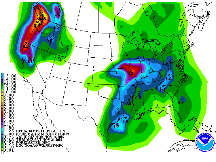
Near none to four inches
16 Nov 2009 06:06 AMThe featured map is the five day precipitation forecast from the Hydrometeorological Prediction Center. The forecast has Iowa in a range of near nothing in Northwest Iowa to around four inches in far Southeast. This is all thanks to a very slow moving storm system that will stay just to our south and east. Some snowfall is expected out of this storm system as temperatures will hover very close to freezing.
Voting:
Good: 23
Bad: 3
Tags: wpc
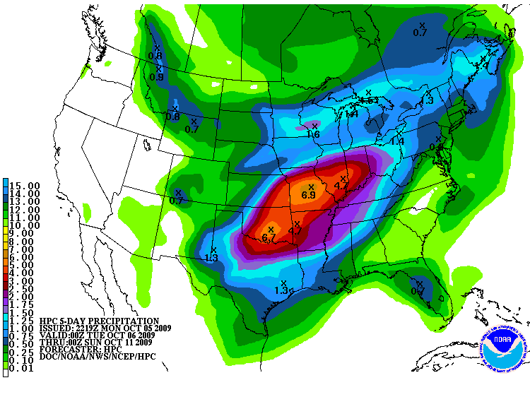
5 Day Rain
06 Oct 2009 05:30 AMThe featured map is the 5 day forecasted precipitation from NOAA's HPC. Up to 7 inches of rainfall is predicted just to our south in Missouri! The prediction for Iowa is of only an inch or so with some of that already fallen since 12 AM this morning.
Voting:
Good: 16
Bad: 5
Tags: wpc
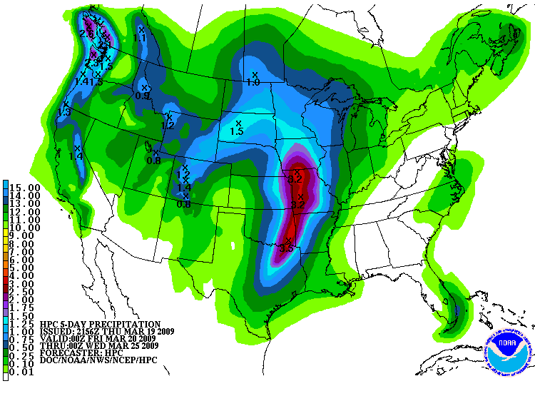
Spring into heavy rainfall
20 Mar 2009 06:17 AMThe featured map is the forecasted 5 day precipitation total from the HPC. A very strong storm is expected on Monday with heavy rainfall and severe weather possible. This all is in time for the start of Spring, which is today!
Voting:
Good: 41
Bad: 22
Tags: wpc

Big rains coming
27 Apr 2006 06:58 AMThe featured image is forecasted precipitation totals from the Hydrological Prediction Center for the next 5 days ending Tuesday morning. Most of the state is painted with values above 3 inches! All of this rain will be thanks to a slow moving storm system that is set to ruin your outdoor plans for this weekend.
Voting:
Good: 56
Bad: 21
Tags: wpc