Past IEM Features tagged: winter1011
The IEM generates per winter storm analyses of snowfall reports over Iowa and tags them by the winter season. Here are the tags used for the previous winter seasons that these maps are available for:
- Winter 2010-2011
- Winter 2011-2012
- Winter 2012-2013
- Winter 2013-2014
- Winter 2014-2015
- Winter 2015-2016
- Winter 2016-2017
- Winter 2017-2018
- Winter 2018-2019
- Winter 2019-2020
- Winter 2020-2021
- Winter 2021-2022
- Winter 2022-2023
- Winter 2023-2024

Snow Storm #17
27 Mar 2011 07:37 PMWhile it was not much for a winter storm, it did dump upwards of 4 inches of snow over extreme southwestern Iowa and probably should be included in the listing of storms for this winter season! Most of this snow melted by later in the day. Heavier amounts occurred over Missouri and more snow even fell today.
Voting:
Good: 3
Bad: 1
Tags: winter1011

Winter Storm #16
09 Mar 2011 03:22 PMOur latest winter storm is now in the books having dumped very wet snow over a good portion of the state. Actual depths of snow did not get too deep, but it was a very wet causing a lot of pain to move around. The good news for snow-haters is that very warm air will make quick work of this latest round of snow.
Voting:
Good: 16
Bad: 5
Tags: winter1011

Winter Storm #15
25 Feb 2011 08:11 AMAn yet another winter storm is in the books for this very active season. The heaviest snowfall totals missed the state to our south this time. Even further south saw severe weather. More chances of snow are in the forecast with the most formidable chance arriving Sunday night into Monday.
Voting:
Good: 15
Bad: 11
Tags: winter1011

Winter Storm #14
22 Feb 2011 10:30 PMWhile Iowa missed out on the very heavy snowfall as shown by the featured map over places to our north, northern Iowa was impacted by a significant amount of icing and then some snow accumulation. Temperatures remained warm enough to the south for just rain and some locations picked up over an inch of it. Another storm system will pass to our south over the next few days with severe weather expected over the southern plains. The impacts for Iowa remain less certain with some models predicting snow and others rain.
Voting:
Good: 17
Bad: 4
Tags: winter1011

Snow Storm #13
06 Feb 2011 07:37 PMWell, it was not much of a snow storm, but did bring upwards of 3-4 inches in extreme eastern Iowa. Temperatures were not too far from freezing and some sunshine helped to keep most roads clear. Things are about to change with a reinforcing shot of cold air set to arrive mid-week and high temperatures struggling to exceed 0 °F!
Voting:
Good: 23
Bad: 10
Tags: winter1011

Snow Storm #12
03 Feb 2011 05:50 AMThe featured map presents an IEM produced analysis of snowfall reports from the epic blizzard. Snow totals over a foot stretched from Oklahoma to Chicago to the east coast. The heaviest totals in Iowa were around 18 inches. The presented map does have one caveat that some of the snowfall from the first storm over the weekend was included in the snowfall reports used to make this map. The departure of the storm has left us bitterly cold air and wind chills well below zero.
Voting:
Good: 26
Bad: 5
Tags: winter1011 blizzard

Snow Storm #11
02 Feb 2011 04:25 AMThe featured map presents snowfall totals from the first of two storms to hit the state over the past three days. The heaviest totals were over north-eastern Iowa. It was not long after this storm that our current blizzard maker began to bear down on Iowa. Travel is not advised over much of the state this morning and wind chills are running way below zero. As bad as things are in Iowa, we are missing the worst of the storm!
Voting:
Good: 30
Bad: 5
Tags: winter1011

Snow Storm #10
24 Jan 2011 07:15 AMAnother snow storm this winter is in the books with the lucky folks in far southwestern Iowa picking up the heaviest totals. There was another storm last Friday that brought an inch or two to central Iowa. The forecast for this week looks rather dry for a change with temperatures actually warming a bit before crashing again next weekend.
Voting:
Good: 23
Bad: 4
Tags: winter1011

Snow Storm #9
18 Jan 2011 05:49 AMThe latest snow storm for Iowa is in the books and the featured analysis shows the heaviest snowfall totals occurring in northeast Iowa with amounts approaching 6 inches. The storm system did bring a surge of warmer air into the state allowing for a brief period above freezing Monday afternoon. That warm air is now gone and has been replaced by a bitterly cold air mass. High temperatures will struggle this week to exceed the single digits.
Voting:
Good: 23
Bad: 6
Tags: winter1011

Snow Storm #8
11 Jan 2011 08:58 AMSnowfall is winding down this Tuesday morning after a prolonged period of snowfall since Sunday brought upwards of a foot near Sioux City. Winds are expected to increase this afternoon which should have little trouble blowing the somewhat fluffy snow around. The next chance of snow arrives late this week and plenty of very cold air will be around to remind us that this is typically the coldest week of the year.
Voting:
Good: 29
Bad: 7
Tags: winter1011

Snow Storm #7
08 Jan 2011 06:35 AMIt has been a couple weeks since our last snow storm and our last winter storm brought very warm temperatures that melted much of the snowpack over Iowa. While this winter storm did not drop heavy amounts of snow as shown by the featured analysis, strong winds on Friday were able to blow this snow around and create blizzard conditions over northern Iowa. Cold air is flowing into Iowa this Saturday morning and is expected to stick around for the remainder of the week.
Voting:
Good: 26
Bad: 5
Tags: winter1011

Snow Storm #6
25 Dec 2010 07:59 AMIowa's Christmas became that much whiter thanks to a snow storm that dumped upwards of 10 inches, with again the heaviest amounts over portions of northeastern Iowa. The snow was not accompanied by strong winds, so travel impacts have not been as bad as they could have been. The good news is that a brief respite from heavier snowfalls is expected, but the bad news is that the forecast models have been advertising a monster storm to ring in the new year.
Voting:
Good: 39
Bad: 11
Tags: winter1011

Snow Storm #5
22 Dec 2010 05:49 AMYet another winter storm brought accumulating snowfall to portions of north-eastern Iowa this December on Monday into Tuesday. The featured map presents an IEM analysis of NWS snowfall reports for 5th major snow storm of this winter season for Iowa. Rochester, Minnesota broke its total December snowfall record with another 10 days to go! Our next winter storm is set to arrive on Thursday, but this time the heaviest amounts are expected over southern Iowa which has been largely left out of the winter fun this December. The good news is that some drier weather is expected after Friday.
Voting:
Good: 13
Bad: 4
Tags: winter1011

Snow Storm #4
17 Dec 2010 05:49 AMThe featured map presents an IEM analysis of snowfall reports from our most recent winter storm. This storm thankfully dropped snow without much wind, so travel issues were mitigated some. Amounts ranged from a dusting over southwest Iowa to near 6 inches from near Mason City to Davenport. The forecast has a quiet period before the next winter storm arrives next week.
Voting:
Good: 52
Bad: 15
Tags: winter1011

Slowing down traffic
15 Dec 2010 05:51 AMThis past weekend's blizzard brought traffic to a near halt across the state as blowing snow reduced visibilities to near zero at times. The featured chart looks at the combination of NEXRAD radar reflectivity, near surface wind speed, and observed traffic speeds from the RWIS site near Adair along Interstate 80 west of Des Moines. The chart clearly shows the impact of precipitation on traffic speeds as the arrival of snow caused traffic to slow around noon on Saturday. The situation deteriorated throughout the afternoon as more snow fell and thanks to 40 mph winds that blew around enough, eventually leading to road closure later that evening. Winds died down by Sunday morning and road crews were able to get I-80 open once again.
Voting:
Good: 37
Bad: 3
Tags: rwis winter1011

Minneapolis gets hit again
13 Dec 2010 11:50 AMIowa's third major snow storm is in the books now and the featured map is a crude analysis done by the IEM of reported snowfall totals. Areas to our north got the largest snowfall totals with a few isolated spots in Iowa reporting near 10 inches. Minneapolis, once again, was hit with heavy snowfall with the biggest news story being the collapse of the Metrodome roof. Our next winter storm arrives on Wednesday with the heaviest amounts expected over northern Iowa.
Voting:
Good: 19
Bad: 4
Tags: winter1011
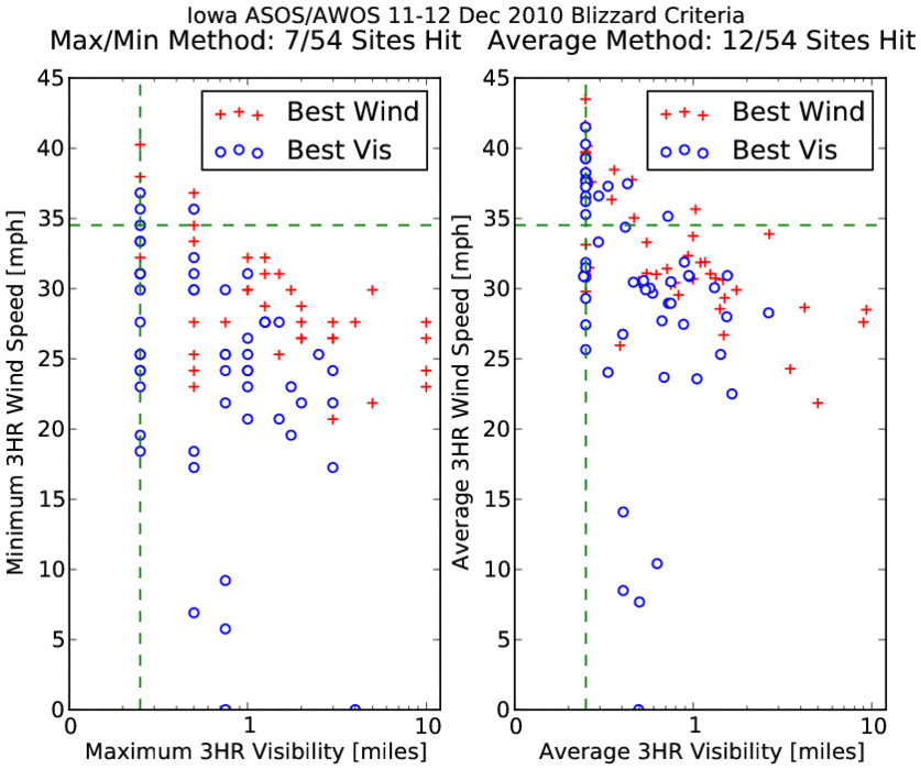
Blizzard Criteria
12 Dec 2010 12:32 PMWith the entire state under a blizzard warning during portions of Saturday and Sunday, one may wonder if the entire state experienced blizzard conditions. The term blizzard is typically applied to a period of at least three hours where visibilities are less than 1/4 mile due to snow or blowing snow along with wind speeds at or above 35 mph. People typically do not stand outside during strong winter storms, so it is hard for them to meet the three hour requirement and only report an instantaneous blizzard. Automated weather equipment struggles at low visibilities... The featured chart shows a comparison between reported three hour visibilities and wind speeds. Both plots contain two sets of data. The 'best wind' dataset includes the variable combination when winds were the strongest. The 'best vis' contains the observations when visibilities were the lowest. The x-axis is shown in log format, so to visually see smaller values. The left hand chart uses max/min values over the three hours, while the right hand chart uses simple averages (helping out the wind criteria). Even using the more lenient method, only ~20% of the sites in Iowa hit blizzard criteria in this qualitative form. For those that were outside, they probably considered the weather blizzard like.
Update: NWS Directive has the blizzard warning criteria as "Sustained wind or frequent gusts greater than or equal to 35mph accompanied by falling and/or blowing snow, frequently reducing visibility to less than 1/4 mile for three hours or more." (but no definition of what "frequently" means)
Voting:
Good: 39
Bad: 10
Tags: winter1011 blizzard nws
Blizzard Warning for the entire state
11 Dec 2010 07:28 PMA powerful winter storm system is winding up this Saturday evening over Iowa with the entire state now under a blizzard warning as shown by the featured map. The counties shown in pink also have local civil emergencies warning motorists to stay home as no help will be available if they get stuck. Winds have been extreme with gusts over western Iowa topping 60 mph. In the wake of this storm system, very cold air is set to arrive on Sunday and Monday with highs hopefully in the single digits.
Voting:
Good: 45
Bad: 6
Tags: winter1011 blizzard

Snow Storm #2
04 Dec 2010 02:00 PMOur second major winter storm of the season is now in the books. The heaviest totals fell from Minneapolis down through Dubuque making the northeast corner of the state the lucky ones this time. With the system departing to our east today, very cold air is on the way with highs on Monday only expected in the teens!
Voting:
Good: 34
Bad: 9
Tags: winter1011

Snow Storm #1
13 Nov 2010 08:32 PMThe first storm of the winter season was a wet one with heavy snowfall totals reported from Omaha to Duluth. A few locations in Iowa reported upwards of a foot of new snow! The rest of the state saw heavy rainfall totals upwards of two inches. The featured analysis is based on NWS provided local storm reports and it is still snowing over portions of Minnesota this evening. None of this snow will struggle to stick around as temperatures are expected to be warmer than freezing for the next few days.
Voting:
Good: 74
Bad: 18
Tags: winter1011