Past IEM Features tagged: tornado
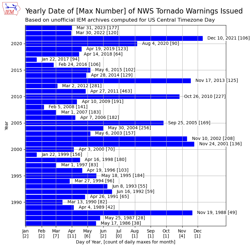
Date of Yearly Max Tornado Warnings
21 Nov 2023 05:30 AMSevere convective weather returned to the US on Monday with the NWS issuing a number of Tornado Warnings over the Louisiana and Mississippi area. Having significant outbreaks during the month of November is certainly not out of the ordinary as the transition month features the classic clashes of air masses over the southern US. The featured chart presents the unofficial IEM computed yearly date of maximum number of Tornado Warnings issued. Each bar is labelled with the date and the number of warnings issued for that date. The months are labelled at the bottom with the number of yearly maxes for that month. Only July is shown to have had no yearly maxes since 1986, which makes sense as the month has the least frequent aforementioned clashes of strongly contrasting air masses. The overall maximum is the outbreak of 27 April 2011 with a mind bending 463 Tornado Warnings.
Voting:
Good: 11
Bad: 0
Tags: tornado nws

Tornado Warning Polygon Heatmap
29 Mar 2023 05:30 AMSevere Weather Awareness Week continues today with the statewide tornado warning drill at 10 AM. So today's feature takes a deep dive into NWS Tornado Warnings. The NWS issues Tornado Warnings by polygon, which is a spatial area defined by latitude and longitude boundaries with only 0.01 degrees of resolution at the vertices. The featured map presents a heat map of these polygons warnings by rasterizing them onto a regular grid with each grid cell representing the number of warnings since 2008. There are many interesting artifacts shown on the map. First, you may notice a number of white slivers that have not seen a single polygon warning over this period. Second, there is an east to west frequency bias shown over counties due to an unfortunate legacy artifact of how NWS warnings are still tied to counties. NWS polygon warnings are often drawn to the county border, which implies for a storm moving generally east that the eastern portion of a county will see a higher number of warnings than the western portion. Those issues aside, some climatological "hot spots" in the state are readily apparent and likely have some physical/meteorological reasons that they exist. Being a far distance from a NWS RADAR likely decreases the chance that a NWS forecaster / RADAR algorithms can see weak tornado signatures with storms.
Voting:
Good: 17
Bad: 0
Tags: tornado

Tornado Warnings in January
17 Jan 2023 05:30 AMFirst it was the serial derecho of 15 December 2021, then it was the Winterset EF-4 tornado on 5 March 2022, and yesterday Iowa experienced a EF-1 tornado near Williamsburg on 16 January 2023! Each of these cold season convective events are remarkable and somewhat concerning to have happen during a time of year whose weather should be relegated to cold and snow! Having a tornado during January in Iowa is not without precedent as it happened once (at least since 1950) before on 24 January 1967 with 13 tornadoes that day. The featured chart presents the monthly number of tornado warnings for Iowa since 1986 (the start of the IEM curated archive). The four yesterday are the only shown for January, but the caveat is that pre ~1992 data is not of the best quality and the NWS was issuing tornado warnings prior to 1986... Anyway, still a very remarkable event and another cold season convective event for the weather history books!
Voting:
Good: 11
Bad: 0
Tags: tornado

No Tornado Warnings since July
12 Nov 2020 05:35 AMThe warm side of the storm system on Tuesday prompted the issuance of a Tornado Watch that just clipped far eastern Iowa. The issued Tornado Warnings stayed just outside the state over Illinois. Iowa has not seen a Tornado Warning since late July as shown by the featured chart. Note that tornado warning counts do not equate to observed tornado counts as a number of tornadoes were reported during the 10 August Derecho. The left most plot displays the yearly accumulated number of warnings over the state based on unofficial IEM archives. Only one other year (1992) since 1986 is shown without a warning after 1 August. Of course, the year of 2020 is not over yet and the way things have gone, we'll see a tornado outbreak during December!
Voting:
Good: 14
Bad: 0
Tags: nws tornado
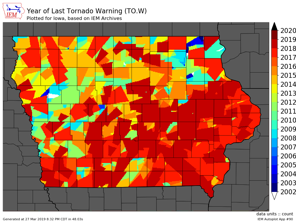
Tornado Warning Collage
28 Mar 2019 05:34 AMThis week is Severe Weather Awareness Week with Wednesday featuring the statewide Tornado Warning drill. The featured map looks like a collage of patches, but represents the year a location in the state last received a Tornado Warning. This analysis is based on the storm-based polygons issued by the NWS and not the associated counties included in the warning. These polygons were not operational until 2007, but were unofficially issued since 2002. The white slivers on the map would indicate no tornado warnings for that location since at least 2002.
Voting:
Good: 14
Bad: 1
Tags: tornado

July 19th Tornado Outbreak
20 Jul 2018 05:34 AMWhen one thinks of tornado season in Iowa, the month of July is not the first thing that comes to mind. The Tornado Outbreak of July 19th will be remembered for quite some time around Iowa. The event started with many photogenic funnel clouds and small tornadoes. Some of these tornadoes did damage in places like Altoona and Bondurant (northeastern suburbs of Des Moines). Larger and more destructive tornadoes followed later in the day with the cities of Pella and Marshalltown taking direct hits. The Pella tornado passed by the KCCI-TV webcam, but the viewing was difficult with the featured image being one of the better views it got. A YouTube timelapse from the webcam is available for your viewing.
Voting:
Good: 18
Bad: 2
Tags: webcam tornado

Tornado Warning Polygons
28 Mar 2018 05:33 AMThis is Severe Weather Awareness Week in Iowa and Wednesday's topic is tornadoes. Tornadoes have been recorded in Iowa during each month of the year and about every hour of the day. The NWS issues Tornado Warning "Storm Based Warnings" in the form of geographic polygons. While the featured map may look like your grandmother's quilt, it is actually a map showing the last year a location in the state was under a Tornado Warning. The archive for these polygons goes back to 2002, but they were not the operational warning until late 2007. There are a number of interesting artifacts on the map including some slivers of the state that have not seen a polygon Tornado Warning since at least 2002. You can generate maps like these on this website for other states along with many other options too!
Voting:
Good: 15
Bad: 1
Tags: swaw nws tornado
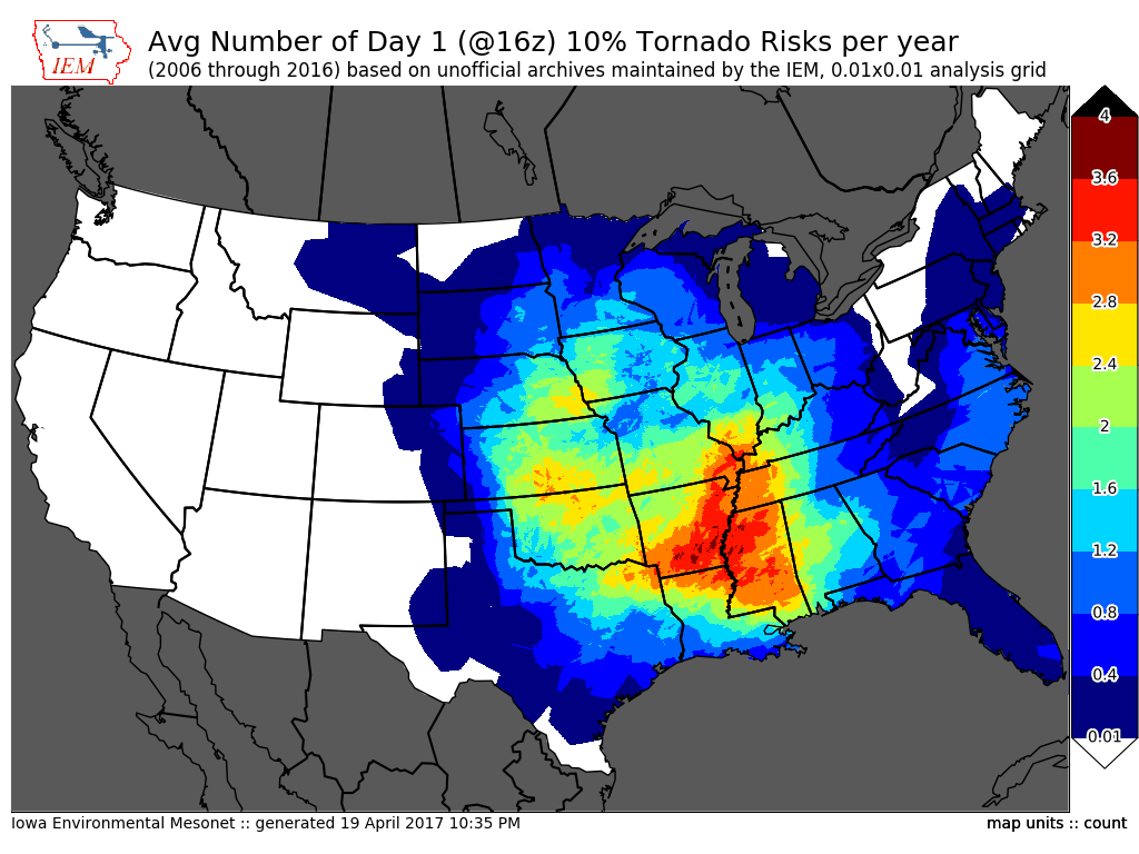
10% Tornado Risk
20 Apr 2017 04:12 AMWith the late morning update yesterday, the Storm Prediction Center had a 10% tornado risk analyzed over parts of Iowa for Wednesday. Thankfully, only a few brief tornadoes were reported near Carroll. The 10% risk threshold only happens a few times each year as highlighted by the featured plot. The map presents the average yearly frequency of having a 10% risk threshold issued. The values for Iowa are in the 1 to 3 days per year range. Kind of interesting to see the highest frequencies show up in the eastern portions of the traditional "Tornado Alley".
Voting:
Good: 7
Bad: 0
Abstain: 1
Tags: spc tornado
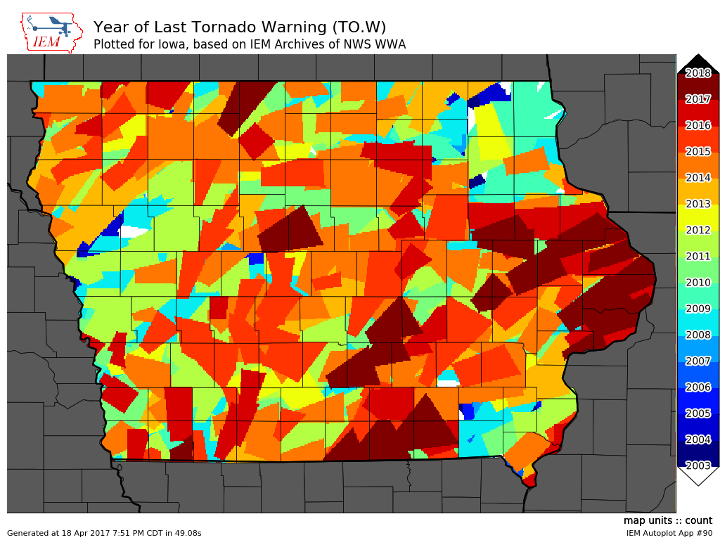
Last Tornado Warning Polygon
19 Apr 2017 04:21 AMSince October 2007, the National Weather Service's official Tornado Warning was geographically represented by a single polygon. These polygons are also associated with the counties they occupy and often the counties are what is reported. Anyway, just considering the polygons the featured map displays the year of last tornado warning based on the polygon coverage. While the polygons were not official prior to 2007, they were issued experimentally and are included in this analysis. The potpourri style map shows that some areas of the state have missed all the tornado warnings since 2003! There is a tornado threat in the state today, so hopefully this map does not change (meaning no new warnings) if you generate it tomorrow via the website. You can also generate this map for other states and also isolated to single NWS Forecast Offices.
Voting:
Good: 21
Bad: 0
Tags: tornado
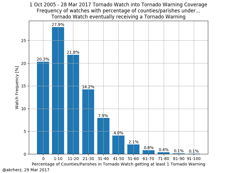
Tornado Watches into Warnings
30 Mar 2017 05:33 AMContinuing with the theme of Severe Weather Awareness Week in Iowa this week, yesterday was the statewide tornado drill with a test watch and warning issued for the entire state. Today's featured chart looks at the conversion of counties under a tornado watch into a tornado warning. For example, if a tornado watch was issued for 60 counties and 30 of those counties received a tornado warning, that would count with the 50% bin for the plot. About 20% of all tornado watches receive no subsequent warning. Most watches have less than 30% of the counties included eventually get a warning. Thankfully, tornadoes typically are not widespread and limited to a couple of high end storms during a typical watch. Hopefully that is the case today with a significant tornado threat expected over the southern US.
Voting:
Good: 7
Bad: 0
Abstain: 1
Tags: nws spc tornado watch
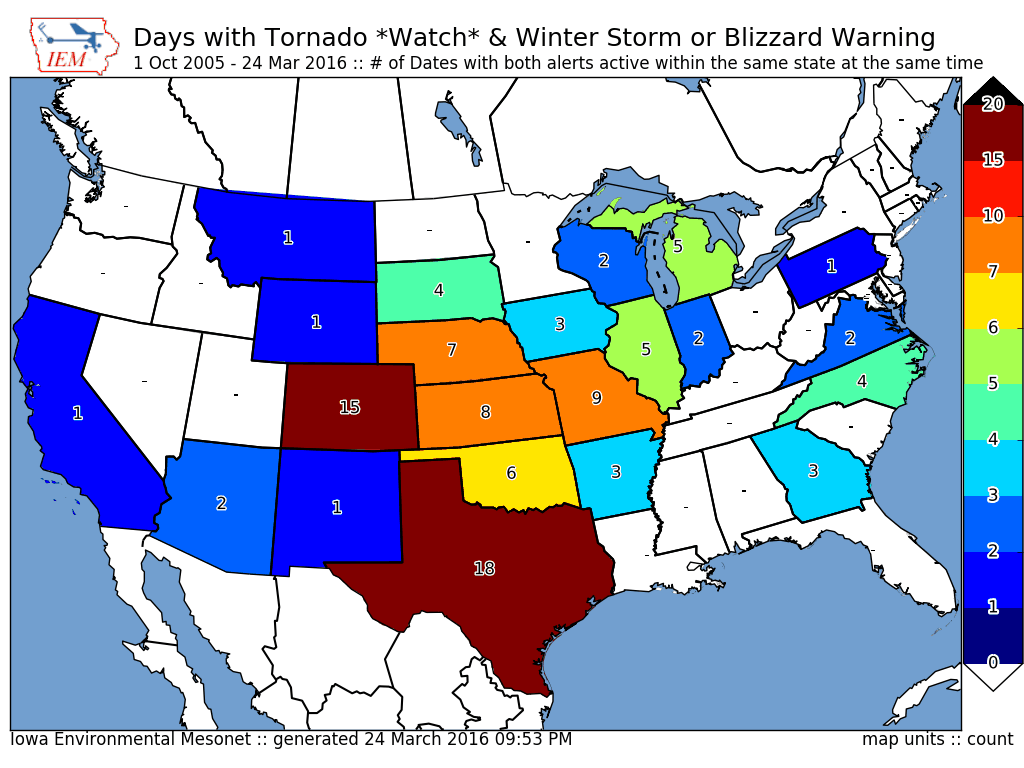
Two sided system
25 Mar 2016 05:34 AMSpringtime storm systems over the plains are often very energetic feeding off the large temperature contrast in air masses present over the United States. While the southern portion of the storm system can feature severe thunderstorms, the northern portion can feature heavy snowfall and even blizzard conditions. On Wednesday, Iowa had both portions over the state at the same time with a Winter Storm Warning active over northern Iowa while southern Iowa featured a Tornado Watch. The featured map presents the number of days with such an event occurring since late 2005. On Wednesday, this combination happened in Iowa, Kansas, and Nebraska. In general, these events are most commonly found in Texas and Colorado.
Voting:
Good: 17
Bad: 1
Abstain: 2
Tags: tornado spring

Last Tornado Warning
16 Mar 2016 05:32 AMThe first significant severe weather event of 2016 hit portions of far southeastern Iowa on Tuesday with a number of tornadoes reported along with issued Tornado Warnings by the National Weather Service. The featured map displays the year of last Tornado Warning issued for portions of the given county. For Allamakee County, far northeastern Iowa, you have to back to 2009 for the last warning! We are done with the severe storms for the near term and only have to deal with very windy conditions today in the state.
Voting:
Good: 15
Bad: 2
Tags: tornado
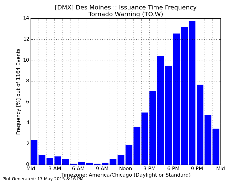
Tornado Warnings by Hour
18 May 2015 05:42 AMEarly Sunday morning, the Des Moines NWS Office issued a few tornado warnings during the 3 and 4 AM hour. The featured chart looks at the frequency of issuing tornado warnings by the office by hour of the day. As one may suspect, tornado warnings are rather rare at that hour, but the overall minimum is a bit later in the morning. The vast majority of warnings are issued in the late afternoon and evening hours as strong thunderstorms need the heating of the sun to drive instability in the atmosphere. You can generate this plot online and you may wish to compare this plot with one from a gulf coast forecast office, like Mobile.
Voting:
Good: 13
Bad: 6
Abstain: 1
Tags: tornado
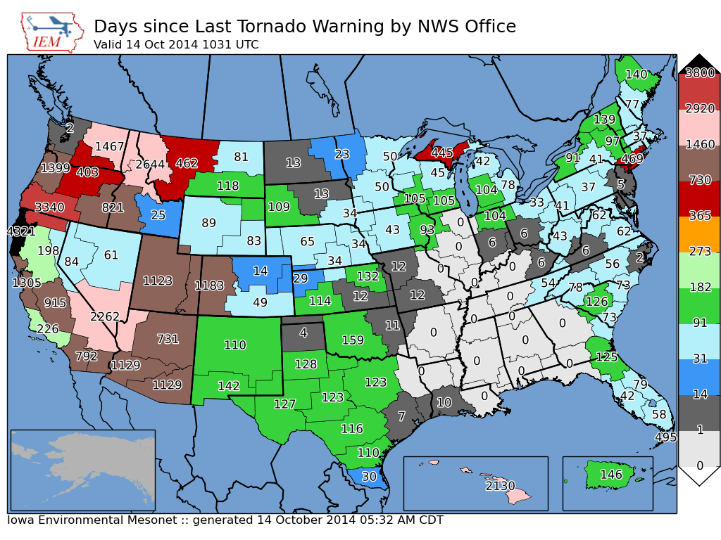
Days since last Tornado Warning
14 Oct 2014 05:44 AMA powerful storm system that has brought us near non-stop rain for the past day also brought plenty of severe weather over the southern plains. The featured map displays the number of days since an individual NWS forecast office has issued a tornado warning. The numerous zeros plotted on the map show the extent of the recent warnings issued. Related to this, just last week, Seattle Washington office issued their first Tornado Warning since 1997! This particular map was popular on the Internet to show Seattle's tornado warning drought. You can generate this map for other warning products as well by clicking the "Generate" button below.
Voting:
Good: 13
Bad: 6
Abstain: 6
Tags: tornado

Watch into Warning
06 Jun 2014 05:42 AMThe Storm Prediction Center issued a tornado watch for portions of northwestern Iowa on Thursday evening. Thankfully the tornado threat did not materialize and no warnings were issued for Iowa after the watch came out. How common is it to have a tornado watch and then not a warning for a given county in the state. The featured map attempts to answer just that question with the percentage of events whereby a county under a tornado watch gets a tornado warning issued. While the percentages may appear low, they do roughly match the spatial confidence of a watch issuance. The overall map average is near 15%. Winneshiek County has the lowest percentage (0%: only 3 tornado warnings since 2005 and all not within a tornado watch) and Pocahontas County has the highest percentage (29%).
Voting:
Good: 47
Bad: 22
Abstain: 15
Tags: tornado nws watch warnings

Year of Last Tornado Warning
12 May 2014 05:44 AMThankfully, the high end tornado threat did not materialize in Iowa on Mother's Day, but there were still a number of storms producing brief tornadoes. The featured map presents the year of the last tornado warning issued by the NWS for a given county. Please note that current warnings are "storm based" and issued for a polygon area, but they are still associated with counties. The map shows Allamakee County with the longest warning drought in the state. Severe weather is possible again today with the highest threat over eastern Iowa.
Voting:
Good: 22
Bad: 3
Abstain: 4
Tags: tornado
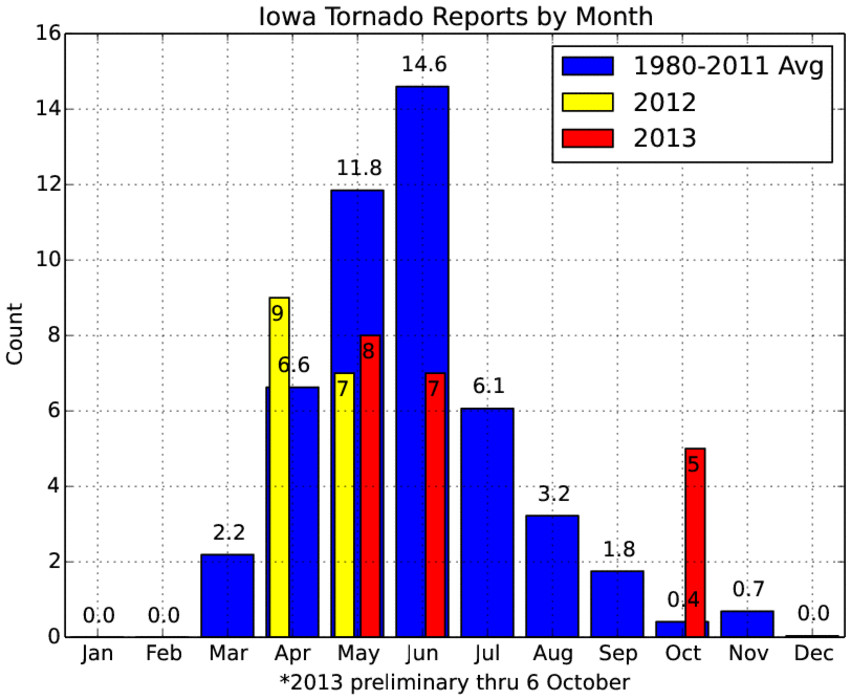
October Tornadoes
07 Oct 2013 05:37 AMThe forecasted tornado threat on Friday materialized with significant tornadoes over eastern Nebraska and northwestern Iowa. The preliminary count for Iowa is five, which is many more than the long term average number of tornadoes in October as shown by the featured chart. The chart shows the monthly average using data back to 1980 and the monthly totals for the past two years. Needless to say, these past two years have seen many fewer tornadoes than on average. Dry weather is in the forecast with very pleasant temperatures.
Voting:
Good: 64
Bad: 5
Tags: tornado
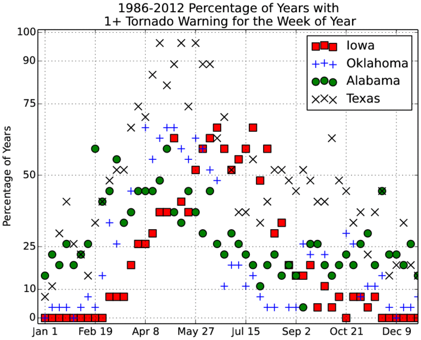
Weekly Tornado Warnings
03 Oct 2013 05:36 AMThe weather is going to be very interesting over the next few days with chances of severe weather, including perhaps tornadoes, in the forecast. October is not a favored time of year for tornado warnings as shown by the featured chart. The chart shows the frequency of having at least one tornado warning issued for the given week of the year. For comparison, values for four states are plotted. Of course Texas is a very large state in Tornado Alley which helps its numbers. It is kind of interesting to compare the annual cycle for Iowa vs Oklahoma and even Alabama. Tornado Warning frequencies in Iowa drop to zero during the winter season while Alabama has the occasional event thanks to its proximity to the Gulf of Mexico. Please note that this type of comparison does not account for the total number of warnings issued but just attempts to diagnose annual climatology.
Voting:
Good: 75
Bad: 9
Tags: warnings tornado
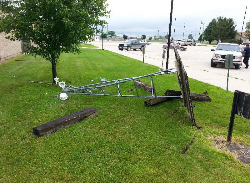
Belmond Tornado
13 Jun 2013 05:42 AMA number of tornadoes were observed in Iowa yesterday and the featured image is the result of one in Belmond, Iowa. That tower with weather instruments on it should be on the top of the school in town, but the tornado thought it looked better laying sideways on the ground. Fortunately, there were no injuries in town reported with this tornado and unfortunately, the sensors did not record any interesting data as the tornado passed by. More severe weather arrives tomorrow and for the weekend.
Voting:
Good: 87
Bad: 20
Tags: tornado

Tornado Warning Days
19 Aug 2012 03:13 PMFor temperature and precipitation, it has been well established that this growing season has been a lot like 1988 (our previous worst drought year). It is interesting when other metrics, like the one presented in today's feature plot, equal 1988 as well. The featured chart presents the number of days per year with at least one tornado warning issued for somewhere in the state of Iowa. Due to the nature of having severe convection happen over midnight, a day is considered to be a 24 hour period ending at 7 AM. This year has only seen 6 days, which is the smallest total since 1988! The green bar represents the number of days after 19 August until the end of the year. 1988 saw an additional day with tornado warnings issue, will 2012 as well?
Voting:
Good: 30
Bad: 5
Tags: tornado
Tornado Watches and wind
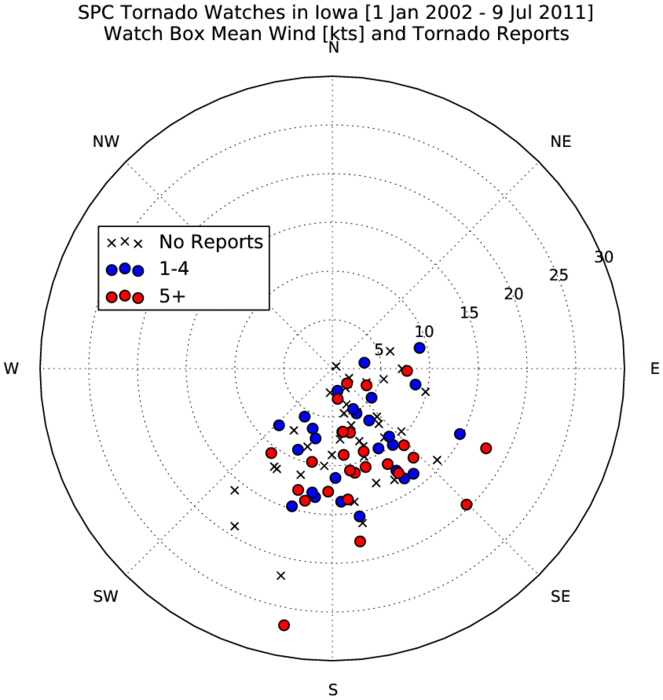
12 Jul 2011 06:19 AMThe featured chart presents an analysis of averaged surface wind speed and direction over the domain of a Storm Prediction Center issued tornado watch that was centered over Iowa. The wind values are for a period near issuance. The symbols represent the number of tornadoes reported within the watch box. The plot nicely shows that winds from the southeast to southwest are the most common with a sharp cutoff at the southwest direction. Tornadoes form in environments of wind sheer where wind speeds and/or direction change with increasing height in the atmosphere. So having surface winds out of the southeast and upper level winds out of the west provide the sheared environment in Iowa.
Voting:
Good: 17
Bad: 9
Tags: spc tornado
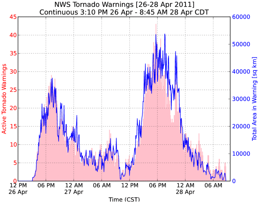
41.5 Consecutive Hours of Tornado Warnings
28 Apr 2011 05:58 AMThe tornado outbreak of yesterday may go down in the record books as the largest in US history. The featured chart displays, at five minute intervals, the total number of active tornado warnings and areal coverage of these warnings expressed in square kilometers. Since 3 PM on Tuesday, there has been at least one active tornado warning making for a streak of 39 straight hours (at the time of this writing). At its peak yesterday evening, the areal coverage of would have been large enough to cover roughly one third of Iowa. I'll update this chart once the streak ends and post the final duration number.
Update The streak ended at 8:45 AM CDT
Voting:
Good: 23
Bad: 7
Tags: tornado outbreak

Tornadoes, after dark
10 Apr 2011 06:48 AMA handful of powerful supercell storms lifted northeast along the warm front Saturday evening putting down a number of tornadoes. The featured map is a summary of the local storm reports with most of those tornado reports coming from one supercell that developed north of Omaha and survived all the way to northcentral Iowa. This situation was particularly dangerous as many of the tornadoes occured after sunset. The town of Mapleton was particularly hard hit with reports this morning of over half of the town heavily damaged.
Voting:
Good: 15
Bad: 3
Tags: tornado
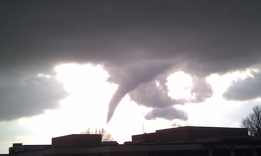
Creston Tornado
23 Mar 2011 05:50 AMIowa's first real taste of severe weather season arrived on Tuesday with a powerful low pressure system pushing through the state late in the afternoon. Numerous frontal boundaries were present over southern Iowa late Tuesday afternoon and helped to spin up some brief tornadoes. The featured image from Tyler Love of Creston shows the photogenic tornado on the northwest side of town. Major temperature changes are in store with a return to winter like conditions for the remainder of the week.
Voting:
Good: 41
Bad: 3
Tags: tornado

Photogenic Tornado
11 Aug 2008 06:28 AMAround 7 PM on Saturday Night, a thunderstorm just to the northwest of Fort Dodge produced a funnel cloud and brief tornado. No damage was reported... This tornado was easily visible from miles around in about every direction and many people took some great photographs.
Voting:
Good: 37
Bad: 17
Tags: tornado

Parkersburg EF5
28 May 2008 08:00 AMThe official NWS rating for the Parkersburg tornado is EF5. This places the tornado in the top-most category. This rating is based on a survey of the damage compared against a series of damage indicators. This tornado is the strongest Iowa has seen in 32 years. Let us hope it will be at least another 32 years before seeing another this strong.
Voting:
Good: 32
Bad: 8
Tags: tornado
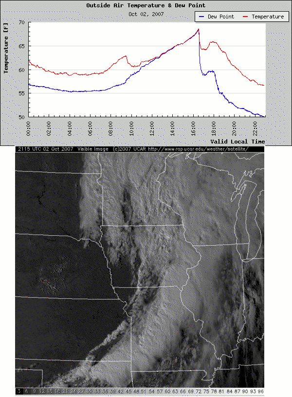
So many interesting things
03 Oct 2007 12:32 AMTuesday was an amazing weather phenomena day. The morning started with Kelvin-Helmholtz instability waves that produced remarkable cloud formations and velocity signatures on NEXRAD. The featured image contains a trace of temperature and dew point from the roof of the Agronomy Building at ISU and the visible satellite image from 3 PM. A large area of rain formed well ahead of the cold front limiting the daytime heating, but it dramatically moistened the lower atmosphere and with the help of strong and warm southerly winds underneath the cloud shield, temperatures and dew points rose in tandem (which is rather rare)! The severe weather threat increased as skies cleared in Southern Iowa ahead of the front during the late afternoon. This bumped surface air temperatures only a few degrees, but provided instability for thunderstorms to develop. The strongly sheered environment along the sharp cold front (notice very sharp drop in the trace) provided the ingredients necessary for a few brief tornados to form, including a tornado that flipped a few cars in Des Moines! What a day!
Voting:
Good: 33
Bad: 2
Tags: khwave tornado interesting
Iowa City, One Year Later
13 Apr 2007 05:34 AMIt has already been a year since a night time tornado ripped through downtown Iowa City causing millions of dollars of damage, but thankfully, no deaths. Unfortunately, there was a death from a different Eastern Iowa tornado that evening. Here are some links to various resources on the event: KCRG-TV, Flickr, the IEM's archive of images, and an excellent page on the Iowa City Public Library website. Don't forget about Wikipedia either.
Voting:
Good: 37
Bad: 12
Tags: tornado

Landspout fun
11 Aug 2006 06:47 AMYesterday afternoon brought some very interesting storms to Northcentral Iowa. The featured image is of a landspout near Dayton (Webster County) and the NEXRAD reflectivity during that time. These funnels form during the initial storm updraft stretches atmospheric spin in the vertical. These funnels are brief and not all of them reach the ground. Here is a collection of other funnels from Thursday.
Voting:
Good: 27
Bad: 8
Tags: tornado
Terrible Thursday
14 Apr 2006 07:05 AMUp until about 7 PM, Thursday would have went down in Iowa weather lore for being a record warm day. All of that heat helped to fire an explosive thunderstorm complex that brought numerous reports of large hail and unfortunately a number of destructive tornados to Eastern Iowa. More severe weather is possible today and especially again on Saturday as severe weather season 2006 continues on at a record pace.
Voting:
Good: 58
Bad: 31
Tags: tornado
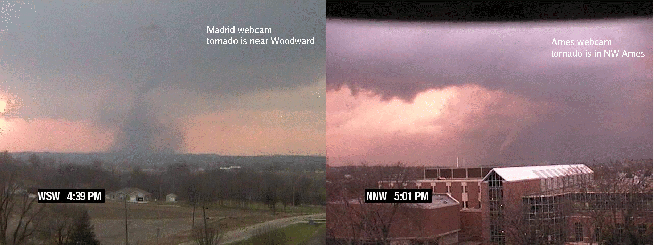
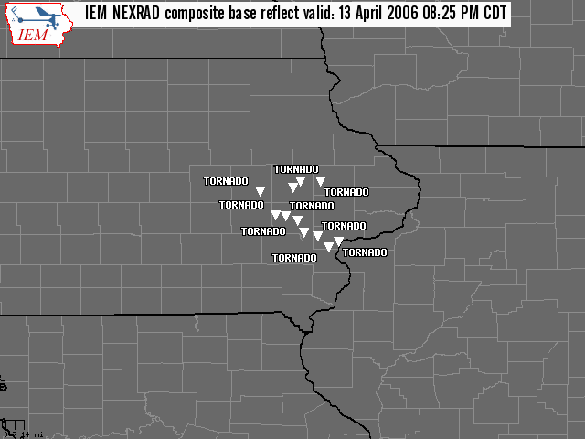
9 tornados on Saturday
14 Nov 2005 06:51 AMSevere storms developed late Saturday afternoon in SW Iowa and raced to the northeast producing 9 tornados along the way. Schoolnet8's network of webcameras caught two (Madrid and Ames) of these tornados. Be sure to check out these helicopter storm survey photos courtesy of the good folks at Iowa Helicopter. The National Weather Service has an excellent summary page of the event.
Voting:
Good: 24
Bad: 4
Tags: tornado webcam
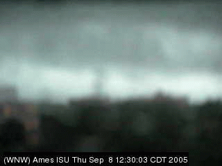
Direct Hit
09 Sep 2005 07:21 AMThursday was a wild day for weather on the ISU Campus. A weak tornado touched down on campus and produced a narrow path of extensive tree damage. The Agronomy Building, which houses the IEM, took a direct hit. The featured image is a shot from the webcamera sitting ontop of the Agronomy Building just before it hit. Unfortunately, the big-foot image quality may tend to discredit its veracity, but the dark cloud in the middle matches up very well with the damage path and time of the tornado. Meteorology undergrad Scott Lincoln put together an excellent page detailing the damage.
Voting:
Good: 43
Bad: 20
Tags: webcam tornado

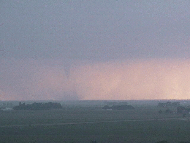
Tornado or Not Tornado II
19 May 2005 07:23 AMIt is time again to play your favorite online game, Tornado or Not Tornado. The image was shot by someone near Farhamville last night. If you are having trouble making up your mind, here are some more photos for your evaluation.
Voting:
Good: 32
Bad: 8
Tags: tornado
Tornado!
12 Jun 2004 12:02 AMKCCI SchoolNet's webcam in Webster City captured one of the many tornados on Friday. This tornado is actually ~15 miles to the SW of the camera! You can view a movie generated by this camera: 3 MB .avi or 400 KB .avi. Internet service for the Webster City site is provided by WMTEL.net.
Tags: webcam tornado