Past IEM Features tagged: lsr

Snow Squall Reports
28 Nov 2023 04:49 PMFor a few years now, the National Weather Service has been able to issue polygon based Snow Squall Warnings. For this season, the NWS added an option to issue Snow Squall Local Storm Reports. The featured map shows such an IEM representation of a report disseminated today in New York. These reports are meant to verify the Snow Squall warnings, so an option was added to IEM Cow accordingly. You can find a LSR download tool along with simple presentations of the raw Local Storm Report text.
Voting:
Good: 9
Bad: 0
Tags: snowsquall lsr
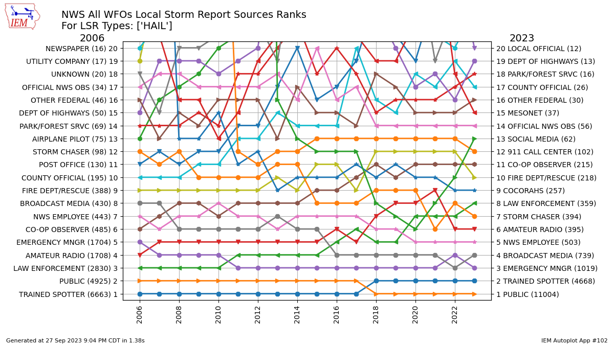
Source of Hail Reports
28 Sep 2023 05:30 AMWhile RADAR provides NWS Meteorologists with high spatial and temporal resolution data of storms, it misses what's happening at the ground surface due to beam tilt and curvature of the Earth (sorry flat-earthers). RADAR also can not explicitly determine hail size that is reaching the ground, so the NWS is heavily reliant on folks to report to them hail size received. When the NWS receives such a report, they often disseminate that observation in the form of a "Local Storm Report" (LSR). The LSR product contains a classification of whom the report is sourced from. The featured chart presents a yearly accounting of these source classifications for hail reports nationwide. The sources are ranked each year for the number of reports received with a line connecting each source type between the years. The top two most frequent sources have not changed over the past eighteen years, but their ordering has. The reason is likely to do with NWS software changes for how LSRs are created with "public" being the current default source and also an increase in social media / NWSChat reports that get lumped into that classification as well. The actual "social media" classification is not extensively utilized, so most reports from there get lumped into public. Anyway, the IEM offers a shapefile download of these LSR reports.
Voting:
Good: 10
Bad: 0
Tags: lsr hail

Inch plus hail reports
24 Jul 2023 05:30 AMWhen the National Weather Service receives reports of weather, they often turn those around to the public in the form of a product called a "Local Storm Report" (LSR). With a couple of hail reports over northeastern Iowa on Saturday evening and some more storms this morning over eastern Nebraska, it is a good time to check on how frequently such hail reports are sent out by the NWS. The featured chart presents the monthly total of LSRs sent by the NWS for locations in Iowa of hail at least one inch in diameter. There are a number of caveats to this chart, with the largest being a change in how the NWS issued and verified warnings with a transition to one inch hail being the threshold for warnings. That aside, the seasonal nature of such reports is readily obvious with May and June being the favored months. There are a handful of reports during the winter months, but those are rare due to the lack of strong instability to support powerful updrafts able to sustain and grow hail stones.
Voting:
Good: 10
Bad: 1
Tags: lsr

2022 LSR Counts
05 Sep 2022 05:30 AMThe featured map presents the number of Local Storm Reports (LSR) issued per NWS office so far this year. There's quite a bit of variability shown on the map with values ranging from 27 to 7,099. While LSRs are issued for reports of severe weather received by the NWS, some offices also issue them for things like snowfall, wind, and rainfall reports. This local preference leads to the large variance shown on the map for neighboring offices. You can generate this map on this website for a time period of your choice and limit the LSRs to specific types of interest.
Voting:
Good: 6
Bad: 0
Tags: lsr

Storm Report Sources
13 Aug 2021 05:21 AMThe National Weather Service collects local storm reports from about every means possible except passenger pigeons. They then relay the credible reports to the world and assign a source designation to the report. The featured chart presents a ranking by year for NWS Des Moines of the source denoted in the local storm reports. The top 20 for the 2006 and 2021 years are shown with a spaghetti of lines connecting the two. The general public reports are an important source of information for the NWS, so be sure to make those reports when it is safe to do so.
Voting:
Good: 15
Bad: 0
Abstain: 1
Tags: lsr

She Shed Storm Report
03 Jun 2020 05:37 AMThe heat and humidity of Tuesday helped to fire some big late afternoon thunderstorms over the Midwestern US. The National Weather Service issues warnings for storms that may produce damaging winds and/or hail. When they get observed reports of such damage, they relay those to the public within a product called "Local Storm Reports" (LSR). The featured map is from the IEM LSR viewer showing one such report yesterday evening near Madison, WI. Based on the IEM's unofficial archives, it may be the first such report of damage to somebody's "She Shed". A bit of levity during these difficult times.
Voting:
Good: 20
Bad: 0
Tags: lsr

NWS Local Storm Reports
28 Feb 2017 05:39 AMThe National Weather Service collects weather reports from their partners and the general public. These reports are then relayed to the world in the form of a text product named Local Storm Reports (LSR)s. The IEM processes and archives these reports to then make them available for download. The featured map displays the number of LSRs by NWS Forecast Office so far this year. Only reports of hail, tornadoes, and severe thunderstorm wind gusts and damage are shown. Significant amounts of severe weather are anticipated today and tomorrow, so areas in the central US that haven't seen much activity yet this year are expected to with this event.
Voting:
Good: 6
Bad: 1
Tags: nws lsr

Local Storm Report Sources
22 Apr 2016 05:34 AMThe National Weather Service collects reports of weather from the public and disseminates these reports in the form of 'Local Storm Reports' (LSRs). These LSRs denote a generalized grouping of where the report came from (source). The featured chart looks at the yearly rank of the source code used in LSR reports by NWS Des Moines. The ranking is simply a measure of the number of reports received and then disseminated by that source over the year. The LSR program has changed over the years with some source groups being converted into other headings. The general PUBLIC remains a major and important source of reports for the NWS. So keep letting them know when you witness significant weather.
Voting:
Good: 13
Bad: 4
Abstain: 3
Tags: nws lsr

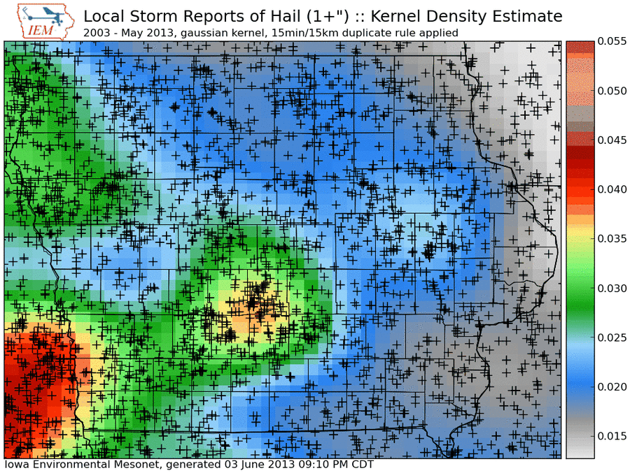
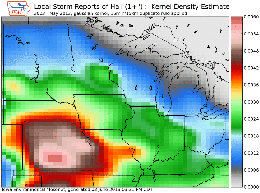
Hail reports
04 Jun 2013 05:48 AMThe featured map presents an analysis of National Weather Service Local Storm Reports (LSRs) of one inch plus diameter hail since 2003. The analysis is a kernel density estimate using a Gaussian kernel and attempts to show the spatial distribution of hail reports. Hail is reported and collected by humans, so it is natural to see urban centers in the state show local maxima for reports. The general pattern is for fewer reports as one travels from southwest to northeastern Iowa. The geography of the Midwest drives the meteorology which favors more instability over the plains. This instability feeds thunderstorm development in the late afternoon hours that tends to produce hail. These thunderstorms then truck it east, congeal and loose their ability to produce hail.
Voting:
Good: 51
Bad: 11
Tags: hail lsr