Past IEM Features tagged: jun10

Could use some breaks
20 Aug 2010 05:58 AMThe featured graphic displays the IEM calculated daily statewide rainfall average since 1 June this year. There has only been one considerable dry period lasting more than just a few days. The recent stretch of weather has not been all that bad thanks to some drier air that worked into the state. Friday looks to return us to "normal" with muggy conditions expected along with storms.
Voting:
Good: 75
Bad: 8
Tags: jun10 jul10 aug10
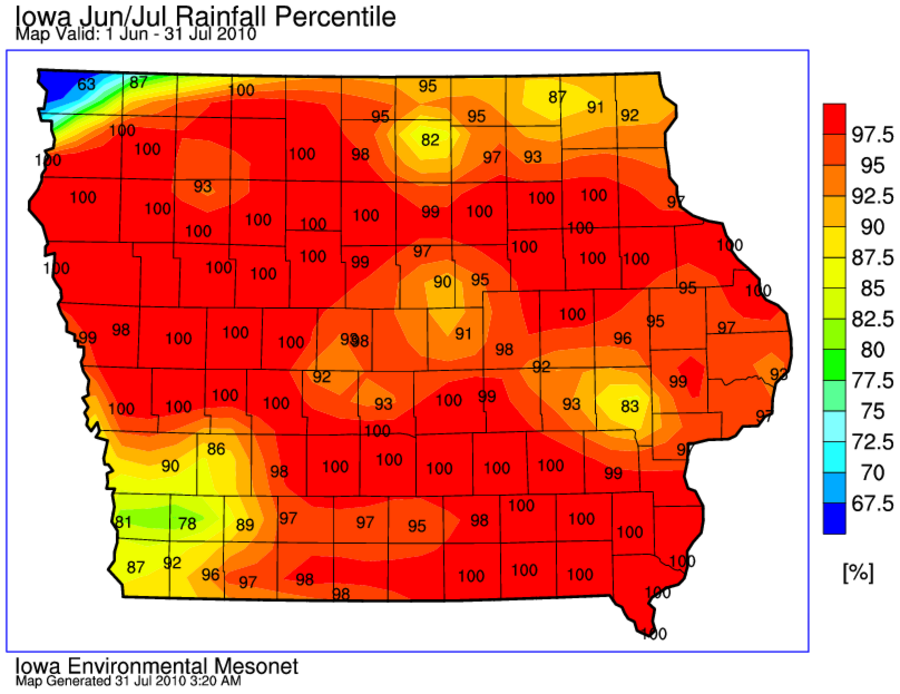
Record June and July
31 Jul 2010 03:25 AMThe featured map presents an IEM computed map of rainfall accumulation percentiles for June and July. A good portion of the state is analyzed at 100%, which would mean this year's total is the highest on record. August looks to get started a bit on the wet side, but lets hope we can have a below average month for precipitation!
Voting:
Good: 215
Bad: 56
Tags: jun10 jul10

Plenty of rainy days
01 Jul 2010 06:11 AMJune is finally in the books! Des Moines had 22 days with measurable precipitation which ties a record set back in 1902. Even with all those rainy days, we ended June on a very dry note with day four of no-rain in progress today. Friday should be dry as well with rain holding off until the holiday weekend. Hurricane Alex looks to impact our weather on Sunday and possibly bring more heavy rainfall.
Voting:
Good: 20
Bad: 2
Tags: jun10 june
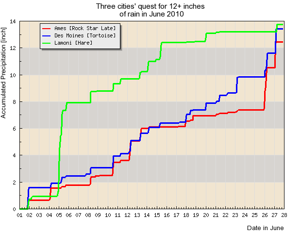
The Race to 12 inches
28 Jun 2010 05:12 AMOnce upon a time, three cities unwillingly entered a race to see which could exceed 12 inches of rainfall for the month of June. Lamoni got off to a quick start and easily reached 12 inches with a half of the month left to go. Des Moines plodded along, slowly but surely reaching the goal. Ames followed along with Des Moines, but took a nap for a week before quickly making up the difference this past last weekend. The moral of the story is that nobody is happy to have finished this race as we are left with considerable flooding impacts. The good news is that dry weather is in the forecast for this week!
Voting:
Good: 45
Bad: 3
Tags: jun10
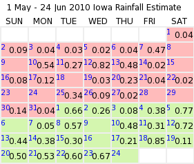
Finally, a dry day!
25 Jun 2010 06:04 AMThursday was finally a day without rain in the state and interrupted a very wet period. The featured chart displays the statewide averaged daily rainfall as estimated by the IEM since 1 May. While values may not appear to be very large, once spread over the entire state it equates into a lot of water! Friday is expected to be mostly dry until later in the afternoon when thunderstorms are expected to develop and stick around into Saturday.
Voting:
Good: 33
Bad: 13
Tags: jun10 may10

Missing out on the (not) fun
24 Jun 2010 06:10 AMThe featured map displays estimated rainfall totals for the past 11 days. While most of the state has picked up 3+ inches of rainfall, others have missed out. Ames is highlighted on the map as a relative minimum compared with its neighbors in all directions. All of this rain has created a mess of farm fields and cities alike. More rain is in the forecast with severe weather a threat as well.
Voting:
Good: 29
Bad: 7
Tags: jun10
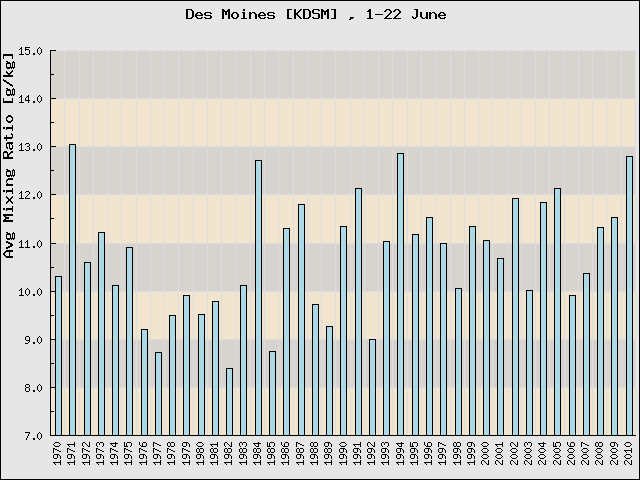
Humid June
22 Jun 2010 05:09 AMThe featured chart displays the near-surface average water mixing ratio reported by the Des Moines Airport for the first 21 days in June for years dating back to 1970. The value is simply the ratio of water mass to dry air mass. This year's value is nearly the highest during this period and the highest since 1994. All of this humidity helps to fuel the numerous thunderstorm complexes that have been relentless over the Midwest this June. Another complex is in Iowa this morning and more are expected this evening.
Voting:
Good: 13
Bad: 6
Tags: jun10
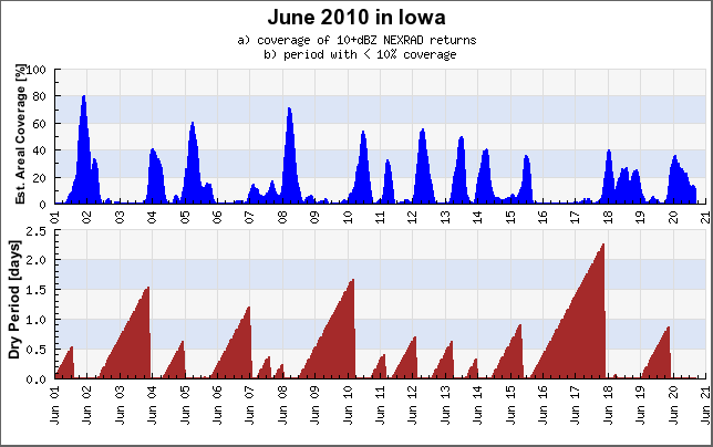
Getting few breaks in June
21 Jun 2010 05:10 AMThe featured graph presents a time series of IEM estimated areal coverage of precipitation over Iowa and the running total time period of having less than 10% of the state covered in precipitation returns on NEXRAD. The bottom chart shows that our dry periods have been brief with the longest period a mere two days. More rainfall is in the forecast this week with heavy amounts likely today.
Voting:
Good: 21
Bad: 8
Tags: jun10

More than enough for June
15 Jun 2010 05:12 AMThe featured map presents NOAA estimated rainfall totals for June based partially on RADAR estimates. The southern half of the state has seen the heaviest of the totals with some locations now approaching 12 inches and the month is only half way over! Scattered showers are in the forecast for the rest of the week, but hopefully the widespread and heavy rainfalls will not be common.
Voting:
Good: 27
Bad: 3
Tags: jun10
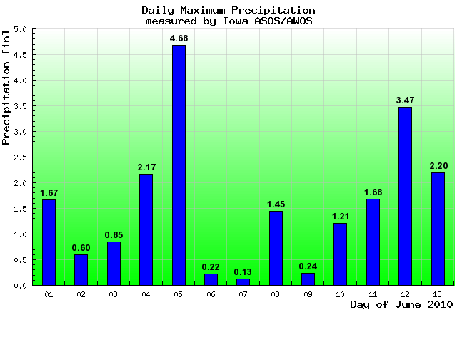
Big rains this June
14 Jun 2010 05:07 AMThe featured chart displays the daily maximum reported rainfall from the automated airport weather sensors in Iowa for June. More than an inch of rain has been observed somewhere in the state all but 5 days this month with more rain falling this Monday morning. A bit drier weather is expected this week, but there will still be chances for rain.
Voting:
Good: 18
Bad: 1
Tags: jun10