Past IEM Features tagged: firewx

Fire Weather Outlooks
06 Apr 2022 05:18 AMWhile the Storm Prediction Center is most widely known for its convective outlooks, watches and mesoscale discussions issued, they also issue "Fire Weather" outlooks with a similar nomenclature to the convective outlooks. The recent and numerous rounds of severe weather over the southern US have dominated the headlines, the fire weather situation over the past number of weeks has been just as extreme. The featured chart presents the daily maximum day 1 fire weather outlook category over the contiguous US. The worsening drought over the southern high plains and constant march of energetic storm systems with high winds have created the prolonged concern over unconstrained wildfire spread. Today's outlook has the highest category possible of "extremely critical" (EXTM).
Voting:
Good: 13
Bad: 0
Tags: firewx
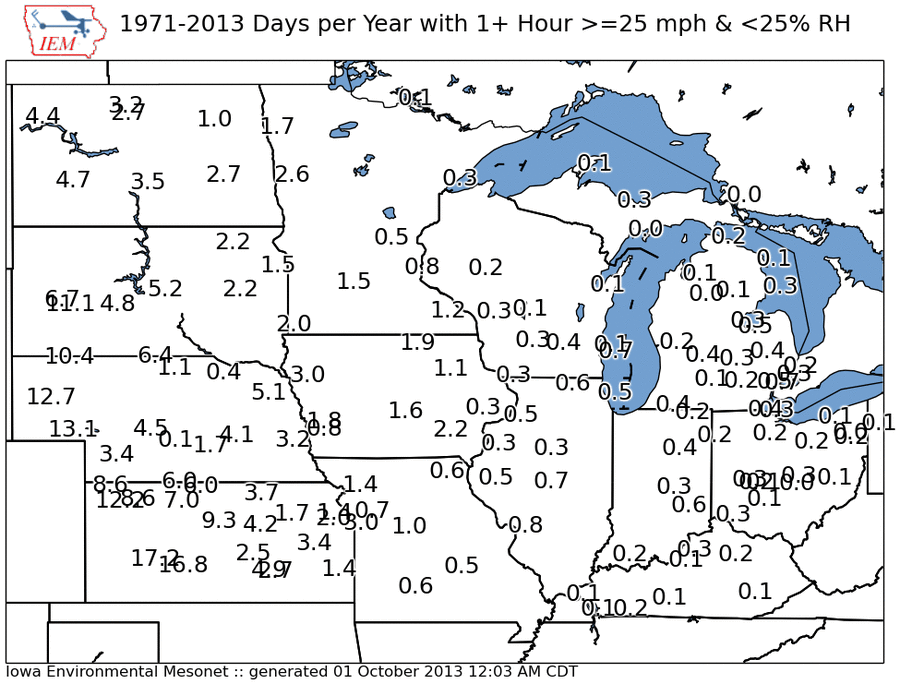
Windy and Low Humidity
01 Oct 2013 05:45 AMA Red Flag Warning was in effect yesterday for limited parts of western Iowa. These warnings are issued when dry and windy conditions create spreading fire concerns. The featured map presents the IEM computed average number of days per year with at least one hour with sustained wind speeds at or above 25 mph and relative humidity below 25%. This combination of conditions gets more rare the further east you go in the Midwest. Dry air masses originating over the desert southwest are slowly modified as they are transported east by vegetation transpiration and evaporation. Also these events are typically with strong southwesterly winds, which means the further east you go, the more likely air originated from the Gulf of Mexico (which will have high humidities).
Voting:
Good: 35
Bad: 8
Tags: firewx