Past IEM Features tagged: bufkit
Hurry Up Next Week!
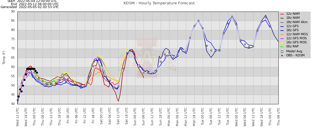
05 May 2022 05:28 AMThe featured chart is courtesy of the venerable Bufkit Warehouse website. The chart displays various forecasts and current observations of air temperature for Des Moines. The chart shows some forecasts out until next Wednesday evening. The up and to the right trend is very welcome and shows some impressive warm arriving next week, which everyone in Iowa is impatiently waiting for. Along with the warmer temperatures, humidity levels will be on the rise and that combination this time of year usually portends to storms. The chart indicates a low temperature around 70 on Wednesday, which would be remarkable for the vast number of recent days nowhere near that warm!
Voting:
Good: 8
Bad: 1
Tags: bufkit

Cold Saturday Morning
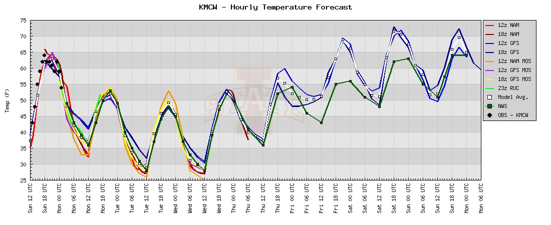
07 May 2020 04:38 AMThe featured chart is of forecast air temperatures for Waterloo from various sources provided by the venerable Bufkit Warehouse website. The plot shows the continued downward slide in temperatures to finish out this week with lows reaching near 30 degrees on Saturday morning. Getting freezing temperatures for early May is not exceptional, but any early planted and tender plants would need to be covered and so the NWS has a Freeze Watch issued for the period.
Voting:
Good: 9
Bad: 0
Tags: bufkit

Cold Weekend Forecast
15 Jan 2019 05:32 AMThere is a bit of excitement among the weather community that very cold weather will show up for the upcoming weekend along with significant amounts of snow beforehand. To make things even more interesting, the NFL AFC Football Championship game is in Kansas City Sunday evening amidst all this snow and cold. The featured chart is taken from the BUFKIT Warehouse showing various model forecast time series of air temperature for Des Moines (KDSM). The chart indicates highs on Sunday barely making it to 0 degrees Fahrenheit!
Voting:
Good: 15
Bad: 0
Tags: bufkit

Snowfall Forecasts
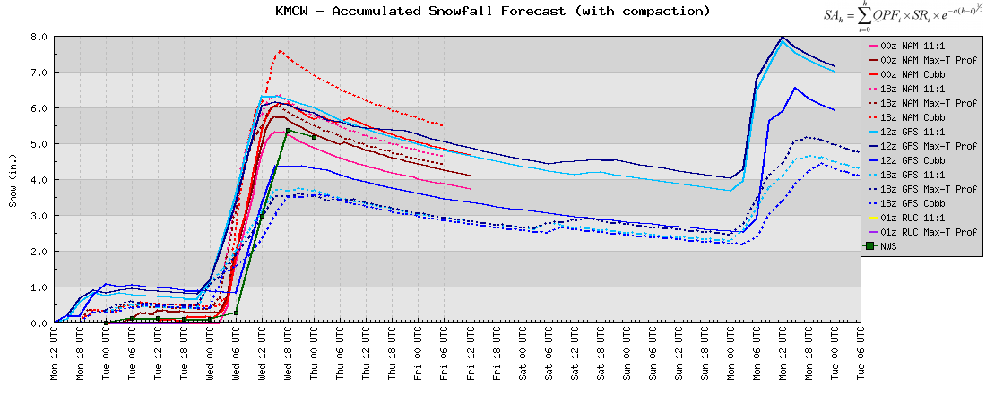
16 Dec 2016 05:35 AMA major winter storm is set to bring snow, blowing snow, and dangerous cold to Iowa this weekend. The featured chart displays forecasted snowfall accumulations from various weather models along with the official NWS forecast for Mason City. The totals shown range from 1.5 to 7.5 inches! While uncertainly exists with the amount of snow that will fall, the strong winds, blowing snow, and cold are undoubtedly going to make this weekend dangerous to be outside.
Voting:
Good: 11
Bad: 3
Abstain: 2
Tags: bufkit

Big Snow Coming?
19 Dec 2012 05:42 AMA significant winter storm is likely to impact central Iowa beginning tonight and lasting through Thursday. The featured chart shows snowfall projections for Des Moines from various operational numerical weather prediction models and snowfall algorithms. These predictions were from model runs made on Tuesday. Some locations are expected to get over a foot of snowfall! The amount of snow will not be the concern as strong winds will blow whatever falls around causing blizzard conditions for most of the state.
Voting:
Good: 26
Bad: 9
Tags: bufkit
Chilly few days coming
09 Apr 2012 05:46 AMToday's feature is contributed by Chris Karstens. After persistent mild weather the past few weeks, a cool-down to more seasonable values is in store this week. The featured chart presents an ensemble forecast of 2 meter above ground surface temperatures for Mason City, with most models suggesting below-freezing temperatures a good possibility on both Tuesday and Wednesday morning. A return to above average temperatures are expected toward the end of the week.
Voting:
Good: 14
Bad: 4
Tags: bufkit

Late September Wind
29 Sep 2011 05:49 AMA strong pressure gradient will exist across Iowa today, and the result will be strong, gusty winds. The featured plot shows a variety of methods that can be used to forecast sustained winds and gusts, using various weather prediction models as well as the NWS forecast compared to observations for Des Moines. Further explanation of these methods may be found here. To view time series forecasts for other cities around the U.S., go here.
Voting:
Good: 18
Bad: 4
Tags: bufkit
Heavy snow and rain coming
07 Mar 2011 09:34 PMOur next storm system is gathering to bring rain and snow to the state on Tuesday into Wednesday. The featured chart is of different forecasts of snowfall for the upcoming period for Mason City. The totals range from 3.5 to 7.5 inches. A big question is if temperatures will warm enough to support more rain than snow. There seems to be little doubt that up to an inch of precipitation will fall over a good portion of the state.
Voting:
Good: 14
Bad: 12
Tags: bufkit
Prolonged snow event
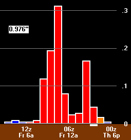
08 Feb 2010 06:10 AMThe featured image is from BUFKIT Warehouse proprietor Chris Karsten showing NAM model output for Slater, Iowa from Sunday evening till Tuesday afternoon. While snow intensities (white bars) are not expected to get very high, the event will last a long time with the snow event totals approaching a foot in some locations. Our brutal winter continues.
Voting:
Good: 30
Bad: 6
Tags: bufkit
Rain, Freezing Rain, Sleet, or Snow
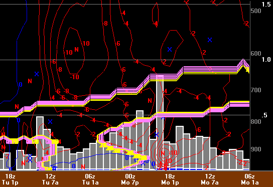
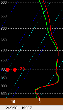
22 Dec 2009 06:17 AMToday's feature is provided by Bufkit Warehouse proprietor, Chris Karstens. Another major winter storm may impact Iowa later this week. This time around, the type of precipitation is the main concern on forecaster's minds. The featured image is a 43 hour forecast of temperature and dew point (deg C) as a function of height (mb), showing an elevated warm layer (red X) of air (> 0 C) residing between two sub-freezing layers of air (blue x) (< 0 C) above Slater, IA Wednesday afternoon. The result of this atmospheric profile would be precipitation in the form of freezing rain or sleet.
Voting:
Good: 22
Bad: 9
Tags: bufkit

Snow and wind coming
12 Jan 2009 06:10 AMToday's feature is provided by BUFKIT Warehouse proprietor Chris Karstens.
The featured plot shows the NAM forecast of hourly qpf (in.) and mean mixed layer wind speeds (mph) for Slater, IA, initialized 6pm CST Sunday. A good shot of snow looks to be on tap this morning, with winds picking up later in the afternoon and evening, gusting near 40 mph, making for blizzard conditions. The National Weather Service has issued blizzard warnings for the expected impact of this morning and this past weekend's snow blowing around leading to whiteout conditions.
Voting:
Good: 23
Bad: 8
Tags: bufkit blizzard
Ice Storm Coming
18 Dec 2008 06:04 AMToday's feature is contributed by BUFKIT Warehouse proprietor Chris Karstens:
The featured plot shows a BUFKIT time series (right to left) of precipitation amount and type from the Wednesday night run of the NWS NAM Model for Ottumwa Iowa. This plot would indicate an inch of ice accumulation between Thursday afternoon and Friday morning. That amount of ice would cause considerable power outages and tree damage. Futher north in Iowa, more snow is expected with accumulations upwards of 8 inches.
Voting:
Good: 46
Bad: 15
Tags: bufkit

Thundersnow coming?
17 Feb 2008 12:53 AMLocal Bufkit guru Chris Karstens sent along a grid point time cross section for Ottumwa showing a very impressive setup for heavy snowfall taking shape on Sunday. The extreme amount of lift (depicted in red contours) is almost certainly convective and probably indicates a good chance for thundersnow. The image also depicts a period of moderate rain and freezing rain leading up to the heavy snowfall.
Voting:
Good: 19
Bad: 8
Tags: bufkit

Super Snow for Tuesday
05 Feb 2008 07:24 AMAnother super day, another super snowfall! Unfortunately, the same area is expected to get the heaviest snowfall today that got the heavy snowfall on Sunday. The featured image is from Chris Karstens, creator of The Bufkit Warehouse, showing a forecasted 11 inches of snow falling near Ottumwa. Our winter continues!
Voting:
Good: 26
Bad: 8
Tags: bufkit

High snowfall rates
22 Dec 2007 07:45 AMThe image shows the hourly time series (right to left) of the NAM's predicted snowfall (gray bars) for Davenport using the model's predicted snow ratio. Saturday afternoon, there is strong lift (red contours) in the atmosphere, the strongest of which is centered in the -12C to -18C temperature range known as the dendritic snow growth zone (purple/yellow contours). When this occurs, it can sometimes lead to enhanced precipitation rates. This image is taken from BUFKIT, you can find out more about this program on The BUFKIT Warehouse website.
Voting:
Good: 22
Bad: 8
Tags: bufkit
3 storms in 1 week
06 Dec 2007 12:00 AMThe featured image is taken from the BUFKIT program. BUFKIT is a model forecast profile visualization and analysis tool kit developed by the staff at the National Weather Service (NWS) office in Buffalo and the Warning Decision Training Branch (WDTB) in Norman, OK. It can be used to look at model soundings for many sites across Iowa and the country. The image is from the GFS model sounding for Des Moines. It shows chances of snow off and on all the way through Tuesday with some sleet forecasted on Saturday! If you are interested with using BUFKIT, check out Chris Karsten's awesome The BUFKIT Warehouse site. Also, did you know that the IEM maintains a BUFKIT archive for sites in and around Iowa since 2006?
Voting:
Good: 40
Bad: 11
Tags: bufkit