Past IEM Features tagged: aviation

Center Weather Advisories
07 Mar 2024 05:30 AMTo support aviation, the NWS has Center Weather Service Unit (CWSU) offices spread throughout the country. These offices issue a number of products that are archived on this website. One of them is the Center Weather Advisory (CWA). The featured map presents a recent CWA issued by the Minneapolis CWSU for some thunderstorm activity clipping northern Iowa on Sunday. The autoplot tool that generated this map isn't all that functional for public usage yet, so the text interface is one of the better places to find these maps along side the raw issuance text. Additionally, the IEM has a shapefile download option for an archive of these alerts.
Voting:
Good: 15
Bad: 0
Tags: aviation cwa

Daily PIREPs
02 Nov 2023 05:30 AMAviators are able to submit Pilot Reports (PIREP) of icing, turbulence, and other weather impacting air travel. These reports are collected by the Aviation Weather Center and disseminated to the world via the National Weather Service. The IEM archives these and makes a simple download interface available for those wanting the raw and decoded data. The featured chart presents a daily accounting of the number of PIREPs coincident with the Minneapolis Air Route Traffic Control Center (ARTCC) over the past year. Summer time is definitely a lull for these reports as the atmosphere is the warmest and least windy (less turbulence). Additionally, summer time storms are more isolated and easier to avoid by routing planes around the storms.
Voting:
Good: 14
Bad: 0
Tags: aviation pirep

March Flight Rules
22 Mar 2022 05:35 AMWhile a fact that is sometimes lost, the primary reason for the weather stations at the airports is to support local aviation needs and not necessarily to tell the general public what the weather is or how much it rained! As such, two of the variables collected by the automated station are horizontal visibility and cloud ceiling heights. These variables are combined into a flight rules rubric that governs aviation activity with the most relaxed rules happening with VFR (Visual Flight Rules). VFR conditions include ceilings above at least three thousand feet and at least five miles of horizontal visibility. The featured chart summarizes the flight rules for Des Moines this march with each box representing the hourly METAR report from the site. This infographic nicely summarizes when ceiling and/or visibility conditions were restrictive.
Voting:
Good: 11
Bad: 1
Tags: aviation
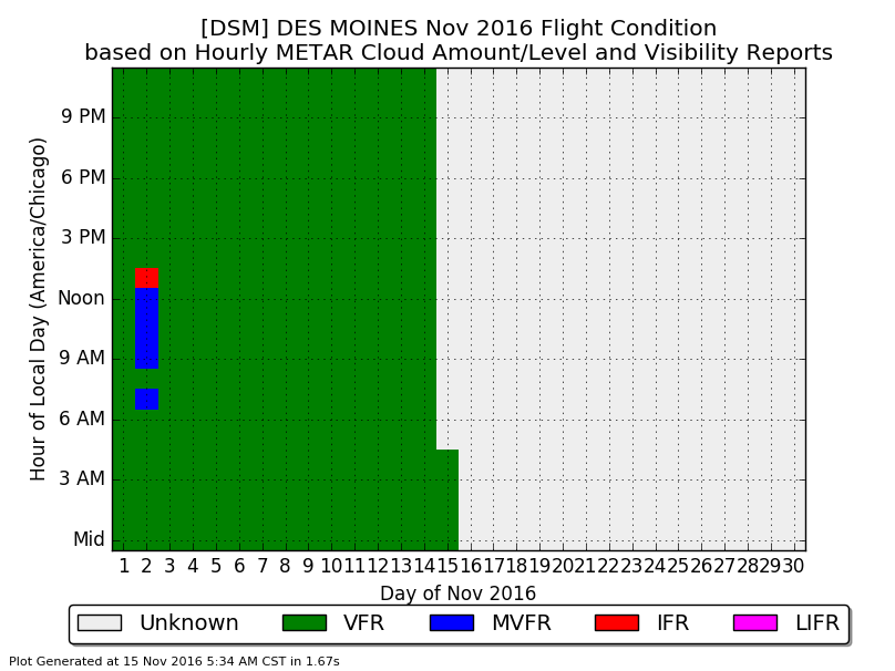
Nearly All VFR
15 Nov 2016 05:34 AMThe primary purpose of the weather stations (ASOS + AWOS networks) located at airports is to support aviation! Besides measuring wind speed and direction, these stations also make important observations of horizontal visibility and an estimate of cloud coverage at altitude. The combination of these later two observations are lumped into four categories that generalize the flying condition. The featured chart displays the hourly flight category as computed by the hourly observations from the Des Moines Airport. VFR (Visual Flight Rules) are the best conditions for flying and for allowing many variants of pilots and flight. This category has dominated for the month with only a few hours on the 2nd in a less favorable category.
Voting:
Good: 11
Bad: 0
Tags: aviation