Past IEM Features tagged: ames

Ames Isolated Shower
10 Jun 2021 05:33 AMThe late afternoon showers over Iowa were very hit or miss, with most of the state in the miss category. Even within a city, a given shower may have been hit or miss with Ames being a great case in point. The featured map presents NOAA MRMS precipitation estimates based on RADAR and observations over Ames. The incorporated city outline is shown along with US-30 and I-35 for some reference. The ISU side of Ames was a hit with the station at IEM headquarters picking up six tenths. Other parts of Ames, including the airport, were a miss with no or just a trace of precipitation reported. The MRMS estimates are not perfect, so there's even some variability found within the pixels shown with estimated rainfall.
Voting:
Good: 19
Bad: 0
Tags: ames

Ames Precipitation Gradient
30 Aug 2016 05:35 AMA few years back, the IEM presented a local seminar on the difficulties of answering a simple question like: "How much did it rain in Ames on a given day?" The rainfall on Monday afternoon was an excellent case in point. The featured chart displays high resolution precipitation estimates by NOAA's MRMS project over the Ames area. The map outline presented is roughly Ames's urban area. The Ames Airport reported just over 3.5 inches of rain in about an hour's worth of time. Meanwhile, portions of northern Ames got a few hundredths! There is even one pixel analyzed to have gotten less than 0.01", which is the common lower limit of measure. The RADAR based estimates presented are even a bit underestimating what fell in the most intense locations.
Voting:
Good: 15
Bad: 0
Tags: ames
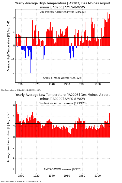
Des Moines vs Ames
10 Nov 2015 05:35 AMWhile the fall to date minimum temperature for the Des Moines Airport has been 34 degrees, the Ames Airport has reported 28 degrees on two separate days. The two airports are only separated by a county's distance, but their micro-climates differ. The featured chart compares the yearly average high and low temperature for the two sites. Please note that this type of comparison is often difficult due to station location and report changes over the years. The Ames site has only recently used data from the airport weather station and is still labelled as the ISU Ag Farm (confusing eh?) Putting that aside, it is interesting to note that while some years had a warmer average high for Ames, the low was always warmer for Des Moines. You can generate this chart for comparing other sites in the Midwest that the IEM tracks.
Voting:
Good: 12
Bad: 4
Abstain: 3
Tags: ames desmoines
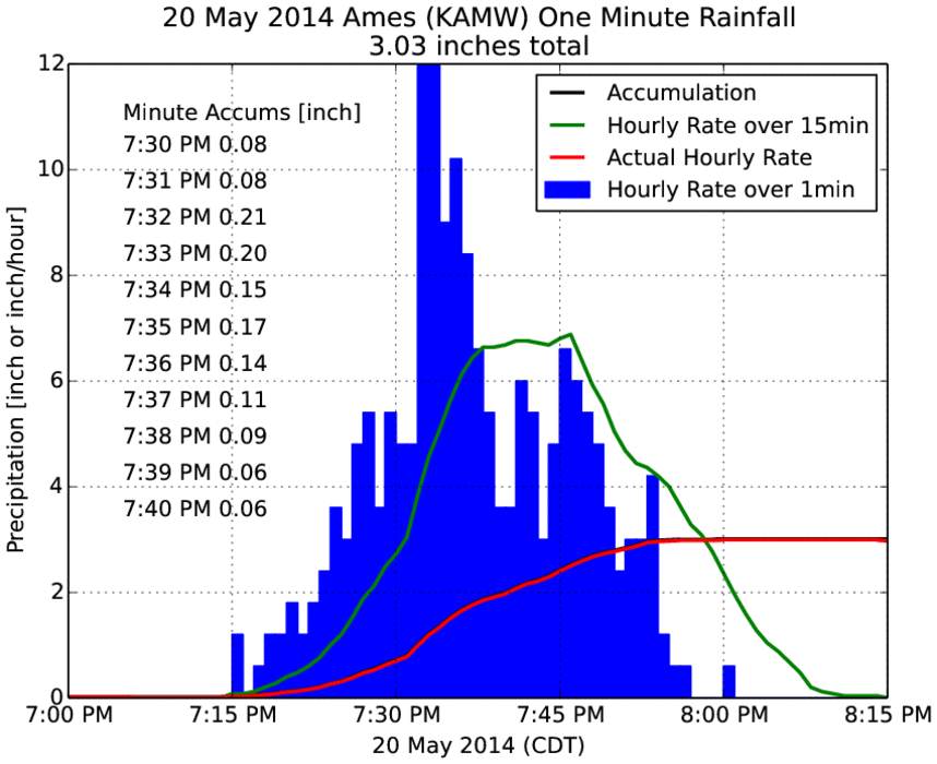
Quick Three Inches
23 May 2014 05:37 AMThe rainfall on Tuesday evening for Ames came very quickly as shown by the featured chart of one minute interval precipitation from the airport weather sensor. The chart displays extrapolated rainfall rates based on the one minute data over different periods. Thankfully, the most intense rainfall rates only last for a few minutes, but they accumulate quickly. The three inches of rain came in a period of less than 45 minutes! For Iowa and flat topography, this is about as intense a rainfall as we can get.
Voting:
Good: 62
Bad: 24
Abstain: 28
Tags: ames heavyrain
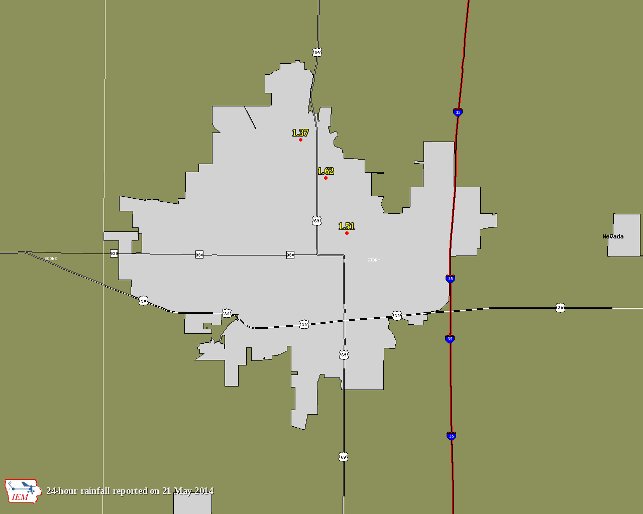
Ames Rainfall Gradient
22 May 2014 05:38 AMLast fall, the IEM gave a presentation on the tedium involved with answering the question of how much did it rain in Ames? With life imitating art, the storm on Tuesday evening produced an amazing rainfall gradient over Ames with CoCoRaHS reports in nothern Ames below two inches and the Airport reporting 3.03! A bunch of hail fell with the storms as well. The airport sensor reported 1.6 inches in just 20 minutes!
Voting:
Good: 23
Bad: 3
Tags: ames
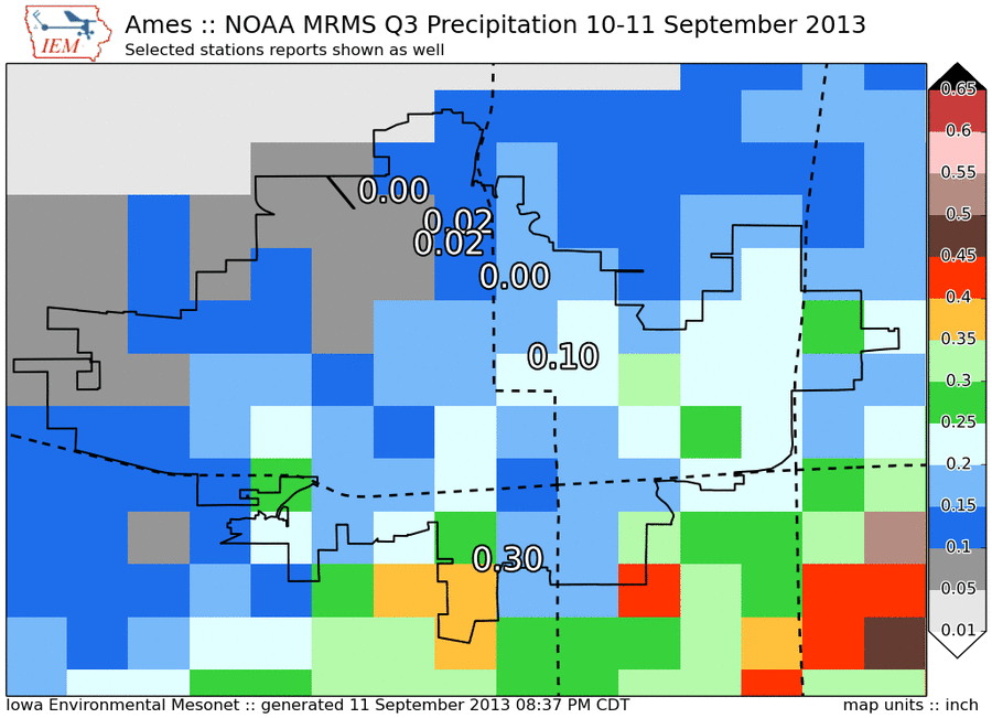
How much rain did Ames get?
12 Sep 2013 05:43 AMOnly a week after the IEM seminar looking at the difficulties of answering the simple question of how much rain did Ames get, life imitates art. The featured map presents NOAA MRMS Project estimate precipitation and local point observations of total rainfall from Tuesday and Wednesday. The map is showing the Ames metro area. The airport reported 0.30" while most of the northwestern section appeared to get just sprinkles. The MRMS estimate shows remarkable cell to cell variability with totals ranging from 0.15" to 0.4" within a few street blocks of each other. So how much rain did Ames get from this event?
Voting:
Good: 109
Bad: 16
Tags: ames

High resolution
03 May 2012 06:01 AMParts of northern Ames were hit hard early Wednesday morning by a thunderstorm complex producing straight line winds upwards of 80 mph. The KCCI SchoolNet8 site in Ames sampled this event at about 6 second resolution and its data is presented in the featured graph. Data for only a seven minute period is shown between 1:49 and 1:56 AM. The peak wind gust of 61 mph occurred very briefly with wind speeds a few seconds later back down to around 20 mph. The pressure trace shows the jump in pressure as the colder thunderstorm air rushes by. The wind direction also shows an organized change from south to westerly winds. While not definitive proof, this plot would not indicate the presence of a nearby tornado as there probably would have been a pressure oscillation and more pronounced change in wind direction.
Voting:
Good: 55
Bad: 8
Tags: schoolnet ames gustfront
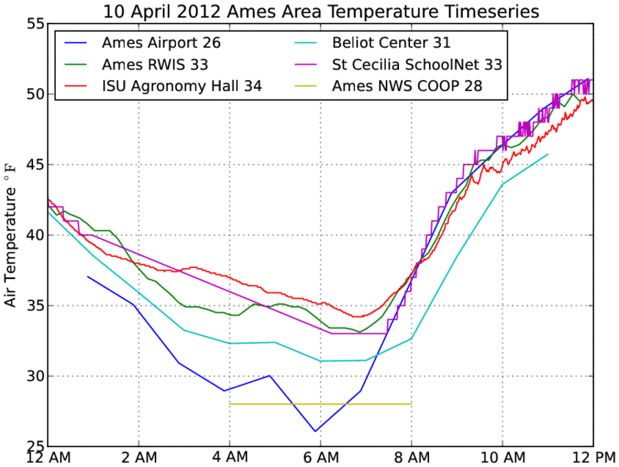
What was the low in Ames yesterday?
11 Apr 2012 05:55 AMWith temperatures near freezing, many anxious folks were wondering what the low temperature was on Tuesday for Ames. The answer is: "depends on who you ask!" The featured chart presents observation time-series for various weather stations near or within Ames. The Airport sensor is the official temperature for Ames and was much colder than any of the other sites. The hourly observations are presented on the chart and the site actually reported a low of 23 in-between the hourly reports. Other sites hovered just above freezing. This chart will be updated later today once the minute interval data from the airport sensor becomes available. Also, the NWS COOP site reports once daily and is represented by the short line. Temperatures are colder this morning, so we will have to see how much damage these two days cause the vegetation
Update: Sorry, the one minute interval data from the airport came in mostly missing for this time period.
Voting:
Good: 21
Bad: 5
Tags: ames temp