Past Features
This page lists out the IEM Daily Features for a month at a time. Features have been posted on most days since February 2002. List all feature titles.
Thu Feb 01, 2018

Mixed Bag for January
01 Feb 2018 05:35 AM
The featured map presents IEM estimated climate district areal averaged precipitation percentiles for January 2018. The map shows remarkable variability over the Midwest and especially over the high plains with a very wet area in Nebraska sandwiched by dry areas to its north and south. Of course, January climatology for precipitation is rather small to begin with so single events over an isolated area can goose these numbers a bunch. Having said that, the current situation in Iowa is depicted nicely with the southeastern portion seeing dry conditions again whereas other parts of the state got more precipitation.
Voting: Good - 11 Bad - 0
Tags: jan18
Generate This Chart on Website
Fri Feb 02, 2018

February Frozen Days
02 Feb 2018 05:34 AM
The calendar day high temperatures on Thursday failed to breach the freezing level making for a frozen day. The featured chart looks at the frequency of such days during February for Ames. The labels on the bars are the actual number of years over the period of record that the high was below 32 degrees. Of course, Feb 29th shows up a bit funny as there have been one quarter as many of those days than others in February. The slope is downward going from just over 50% to start the month to under 30% by the end. So such days become less common as we slowly inch toward spring!
Voting: Good - 14 Bad - 2
Tags: feb
Generate This Chart on Website
Sun Feb 04, 2018

'17-'18 Winter Storm #10
04 Feb 2018 09:42 PM
It may be a bit of a stretch to lump this past weekend's snow producing systems into one storm, but we shall! The featured map displays totals over Saturday and Sunday as portions of far northeastern Iowa reported upwards of four inches. Locations to the south and west picked up much more rain than snowfall from this event. Our next snowfall producing system arrives on Monday, just in time for you to call in sick from work after the Super Bowl!
Voting: Good - 8 Bad - 1
Tags: winter1718
Mon Feb 05, 2018

Highly Variable January
05 Feb 2018 11:39 AM
With a h/t to @climatologist49 on Twitter, the just completed month of January was one of the most variable on record for Iowa and elsewhere. Where this variability is measured by the standard deviation of the daily high temperatures for the month as shown by the featured chart for the central Iowa averaged climate district. The year of 2018 comes in slightly ahead of 1942. This variability can be thought of as having a number of very warm days along with a number of very cold days for the month. February has continued this trend a day already in the 40s and one today in the teens for highs.
Voting: Good - 10 Bad - 1
Tags: jan18
Generate This Chart on Website
Tue Feb 06, 2018

'17-'18 Winter Storm #11
06 Feb 2018 08:19 AM
Finally, a significant snowfall for central Iowa! For Des Moines, the longest stretch of days without receiving three inches of snow ended on Monday with five to six inches reported over the metro area. The featured map displays available snowfall reports and shows a good portion of the state picking up four or more inches. This snowfall caused major traffic issues as snowfall rates and daytime traffic conspired for many accidents. More snowfall is expected later today, but amounts will be much less than this most recent storm.
Voting: Good - 14 Bad - 0
Tags: winter1718
Wed Feb 07, 2018

'17-'18 Winter Storm #12
07 Feb 2018 07:58 AM
The snow producing storms have been coming in quick succession lately. Light snow fell over much of the state on Tuesday evening into Wednesday with the featured map depicting a smoothed analysis of available reports from the NWS. Most reports were generally an inch or less. Plenty more chances of snow are in the immediate term forecast and sub-freezing temperatures, so if you like snow and falling snow, this is a good time of year for you!
Voting: Good - 8 Bad - 1
Tags: winter1718
Thu Feb 08, 2018
January vs February Temps
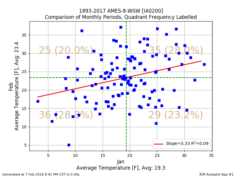
08 Feb 2018 05:33 AM
The January average temperature for Ames came in just under long term average for the month at about 16.5 degrees. The featured chart compares the January average temperature with February for the same year for Ames. Having a below average January does not guarantee the same for the next month. The chart shows each month's average value and the frequency within each quadrant defined by these averages. There is some correlation denoted, which is likely influenced by persistence or dearth of snow cover.
Voting: Good - 6 Bad - 0
Tags: feb jan
Generate This Chart on Website
Fri Feb 09, 2018

'17-'18 Winter Storm #13
09 Feb 2018 09:05 AM
The snow producing winter storms continue at a frantic pace. This most recent storm produced a very sharp southern gradient to the snowfall totals with a stripe near highway US-20 between six and twelve inches. More snowfall is expected later today, but totals are expected to be an inch or snow and focused over southern Iowa.
Voting: Good - 12 Bad - 1
Tags: winter1718
Sat Feb 10, 2018
'17-'18 Winter Storm #14
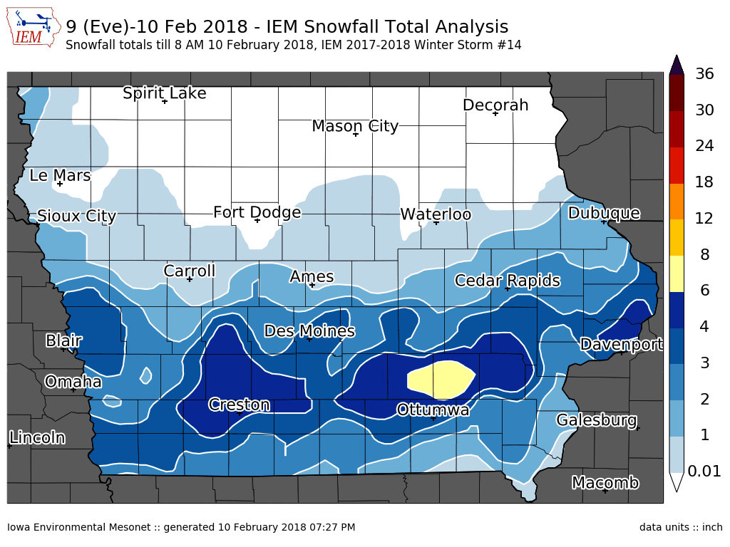
10 Feb 2018 07:31 PM
The snow producing winter storms are coming fast and furious with the most recent storm dumping its heaviest totals over southern Iowa. The featured map displays the combination of NWS COOP, Local Storm Reports, and CoCoRaHS reports for the event. Areas north of Ottumwa reported the heaviest totals over six inches. The next round of snowfall is already here this Saturday evening with the heaviest totals expected over southern Iowa again.
Voting: Good - 5 Bad - 0
Tags: winter1718
Sun Feb 11, 2018

'17-'18 Winter Storm #15
11 Feb 2018 01:55 PM
The snow producing storms are coming faster than I can post IEM Daily Features with an analysis of totals! This most recent round dumped generally light amounts over much of the state with the far southeastern corner receiving the heaviest amounts over three inches. For those of you sick of the snow, it appears a break is on the way with even some above freezing temperatures this week. Having clear skies is also a big help as the ever increasing sun angle is able to heat concrete surfaces to help melt away the packed snow and ice.
Voting: Good - 13 Bad - 1
Tags: winter1718
Tue Feb 13, 2018
Head South to Find Brown
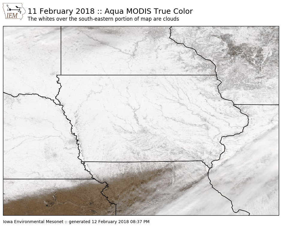
13 Feb 2018 05:33 AM
The clear skies overhead on Sunday allowed for the various satellites to get a good look at our snow covered landscape covering the state. The featured map is from the Aqua MODIS satellite showing a "true color" depicting. Note that there are some clouds over the far southeastern portion of this map, but a clear view of the snow exists over Iowa. It is interesting to see that the snow cover does not persist much farther south into Missouri. They have mostly missed out on the recent snow falls.
Voting: Good - 9 Bad - 0
Tags: satellite modis
Wed Feb 14, 2018
Rule of 43
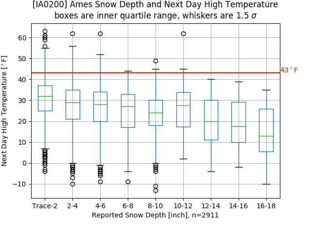
14 Feb 2018 05:33 AM
High temperatures are expected to soar to levels of warmth you should express to your significant other today. But how warm can it get with deep snow cover existing over much of the state? A local forecasting rule of thumb is to not forecast a high temperature over 43 degrees when there is at least four inches of snow depth to start the day. Does this rule hold against long term observations? With a bunch of caveats with how daily snow depth and high temperatures are reported, the featured chart depicts binned box plots for a given snow depth and the following day high temperature. So in general this rule mostly holds, but there are a few observations shown above the 43 degrees and four inch depth. Of course, the reason for this rule is energy is consumed by melting available snow that would otherwise go into heating the air.
Voting: Good - 13 Bad - 0
Tags: snowcover highs forecasting
Thu Feb 15, 2018

Breaking our cold stretch
15 Feb 2018 05:34 AM
Temperatures warmed nicely over the past two days breaking our recent stretch of cold temperatures. The featured chart displays daily high and low temperatures this year for Des Moines along with daily climatology and departures from daily averages (bottom panel). The recent spike to positive departures is certainly welcome for those wishing to get rid of some of the snow and ice that accumulated over our mostly cold and snowy February.
Voting: Good - 7 Bad - 0
Generate This Chart on Website
Fri Feb 16, 2018
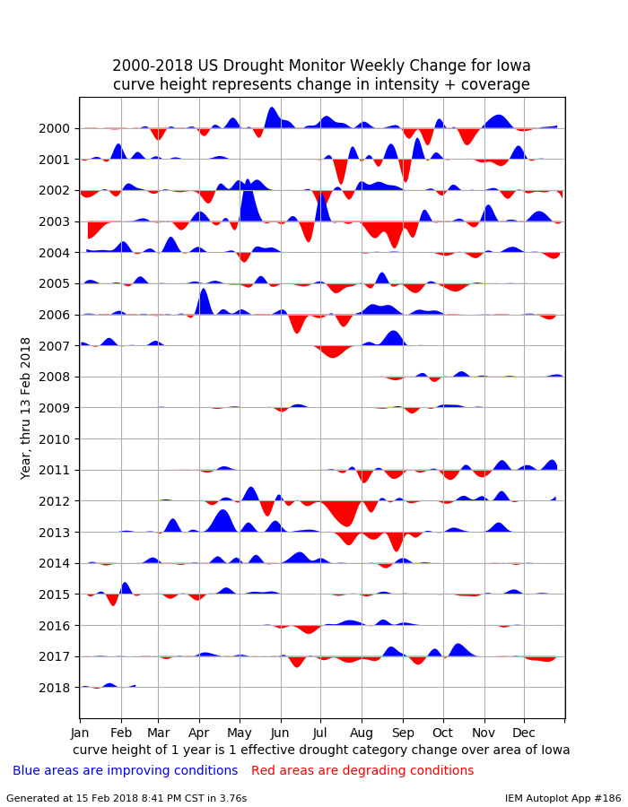
Drought Improvement or Degradation this Spring?
16 Feb 2018 05:34 AM
The newly released US Drought Monitor this week showed a bit of improvement over Iowa thanks to the numerous recent rounds of snow storms. The featured chart looks at the weekly change in drought coverage over Iowa since 2000. The unit height represents a one category change in the coverage of the Drought Monitor over Iowa. Placing aside the difficulty with those units, the blue sections would indicate improvements and red degradation. What's interesting to note in this chart when we think about what may be happening this spring is that having further degradation during the spring season is rather rare. Only 2015 during the past 15 years experienced significant degradation prior to the first of May. So it will be interesting to see what happens this spring!
Voting: Good - 10 Bad - 3
Tags: drought usdm
Generate This Chart on Website
Sun Feb 18, 2018

'17-'18 Winter Storm #16
18 Feb 2018 01:17 PM
A quick moving system brought a brief downpour of snowfall on Saturday which only amounted to an inch or two over the state, but created for some travel impacts due to the intense snowfall rate. Most of this snowfall melted later on Saturday as temperatures warmed nicely to finish the day. Our next storm system will be here tonight.
Voting: Good - 9 Bad - 1
Tags: winter1718
Tue Feb 20, 2018
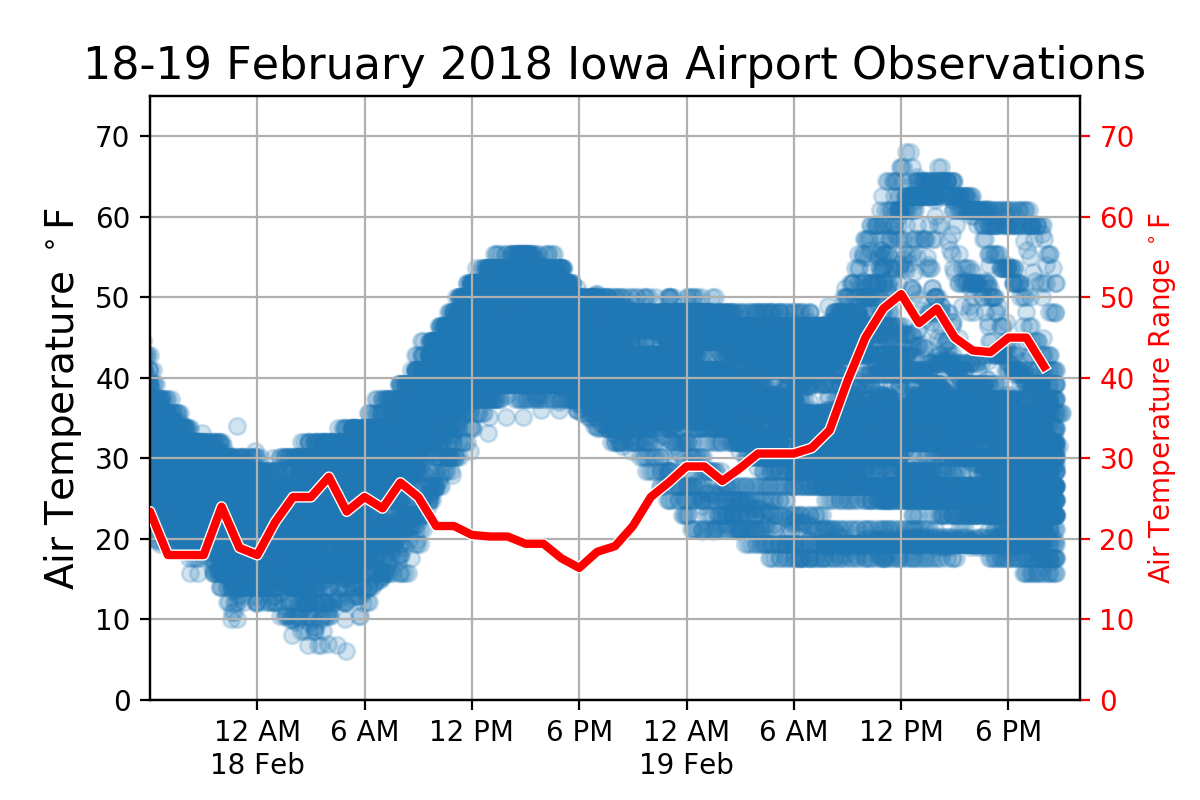
50 Degree Range
20 Feb 2018 05:27 AM
Your location in the state on Monday made a for big difference with how warm it felt. The featured chart displays all Iowa ASOS/AWOS temperature reports for Sunday and Monday along with the hourly range in temperature over the state (red line). This range in temperature briefly touched 50 degrees on Monday as southeastern Iowa was well into the 60s and northwestern Iowa was in the teens! This strong contrast in temperature will make for a wintery mess on Tuesday as conditions will be favorable for freezing rain.
Voting: Good - 10 Bad - 1
Tags: front
Wed Feb 21, 2018

'17-'18 Winter Storm #17
21 Feb 2018 05:32 AM
Our most recent bout with winter brought a mixed bag of precipitation to the state over the past two days. The featured map presents NWS Local Storm Reports showing snow over northwestern Iowa, heavy rainfall over southeastern Iowa, and freezing rain in-between. Freezing rain amounts where generally a tenth of an inch or so. The next wintery mix arrives in a day or so.
Voting: Good - 4 Bad - 0
Tags: winter1718
Generate This Chart on Website
Thu Feb 22, 2018
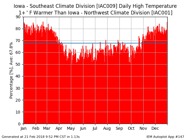
Southeast vs Northwest Iowa
22 Feb 2018 05:32 AM
While temperatures were below freezing for all of Iowa on Wednesday, the warmest locations were found in southeastern Iowa. For the sake of comparison, how often is the daily high temperature for southeastern Iowa warmer than northwestern Iowa? Using the climate district averaged values for this question, the featured chart presents the daily frequencies of having the high temperature one degree warmer for southeast vs northwest. The overall average is shown and frequency for February is about 80% or four out of every five days! While this frequency does drop during the summer months, the value is never shown to be less than 50%.
Voting: Good - 10 Bad - 2
Generate This Chart on Website
Fri Feb 23, 2018

'17-'18 Winter Storm #18
23 Feb 2018 08:20 AM
The winter systems have continued at a fast pace this February and unlike January, these systems have packed a lot more moisture. This moisture should help the drought situation building in the state, but with frozen soils, this water tends to mostly run away. The featured analysis only depicts the snowfall reports, but other locations received some freezing rain and rain. Our next storm system arrives already on tomorrow, Saturday.
Voting: Good - 8 Bad - 1
Tags: winter1718
Sun Feb 25, 2018

'17-'18 Winter Storm #19
25 Feb 2018 08:30 PM
Our most recent winter storm visited the state on Saturday and brought some rain, freezing rain, and snow. The featured map displays available snowfall reports from the event and amounts were generally an inch or two over far northern Iowa. A dusting of snow was reported over locations further to the south. Warmer temperatures arrived on Sunday and are efforting some long awaited snow removal over northern portions of the state.
Voting: Good - 9 Bad - 2
Tags: winter1718
Tue Feb 27, 2018

February Maxes
27 Feb 2018 05:33 AM
Warm temperatures are expected today for much of the state, but some portions of northern Iowa won't be as warm due to considerable snow cover. The featured map displays month to date maximum high temperatures. Up until today, only a portion of southeastern Iowa has experienced 60+ degree temperatures. The northern half will struggle again in the 30s and lower 40s, but it certainly could feel much worse this time of year!
Voting: Good - 8 Bad - 0
Generate This Chart on Website
Wed Feb 28, 2018

2018 Max Temp to Date
28 Feb 2018 05:34 AM
Except for unlucky locations in far northern Iowa, temperatures soared well above average on Tuesday. Cedar Rapids was able to tie a record high temperature for the date of 64 degrees. This is the warmest high year to date for the site which is illustrated by the featured chart. It depicts the climatology of year to date maximum temperature along with the actual observations this year. The remarkable jump up yesterday sticks out as previously the value was just slightly below long term average. Some warm weather remains in the forecast, but nothing as warm as Tuesday.
Voting: Good - 8 Bad - 1
Generate This Chart on Website