IEM Daily Feature
Tuesday, 27 November 2012
Tuesday, 27 November 2012
Snow Cover and Cold Lows
Posted: 27 Nov 2012 05:39 AM
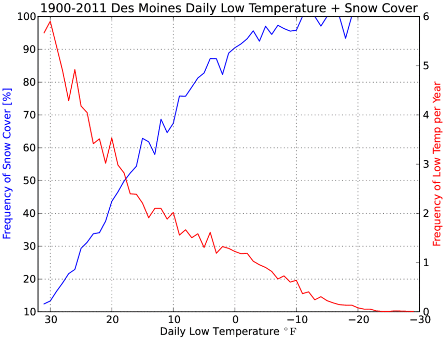
Temperatures dropped quickly Monday evening thanks to clear skies and
calm
conditions. Our saving grace was ground temperatures which are still
warm
for this time of the year and the lack of snow cover, which prevented
temperatures from dropping even further. Snow cover is a game changer
when it comes to the surface energy balance during the day and night
time.
It acts to mostly seperate the exchange of energy from the sun to the
soil
and back to the air. The featured chart presents the frequency of
having
snow cover at a given daily low temperature (blue line) and the
overall
frequency of that temperature (red line). The main point is to show
that
the coldest temperatures are increasing associated with the presence
of
snow cover. For example, a low temperature of zero degrees also had
snow cover present 90% of the time. The chart also had an interesting
(but
unexplained here) aspect of having the lines cross at the 50%
probabilities for both y-axes around 18 degrees. It is difficult for
near
surface soil temperatures to get cold enough to support very cold air
temperatures, so snow cover is increasing necessary for the coldest
temperatures.
Voting:
Good = 40
Bad = 7
Tags: lows snowcover
Voting:
Good = 40
Bad = 7
Tags: lows snowcover